Written and Fact-checked by Whereig Editors | Updated On: May 01, 2026, 13:37 ET
Map of Delaware County - Delaware County is a county located in the U.S. state of Pennsylvania. Delaware County Map showing cities, highways, important places and water bodies. Get Where is Delaware County located in the map, major cities in Delaware county, population, areas, and places of interest.
Map of Delaware County, Pennsylvania
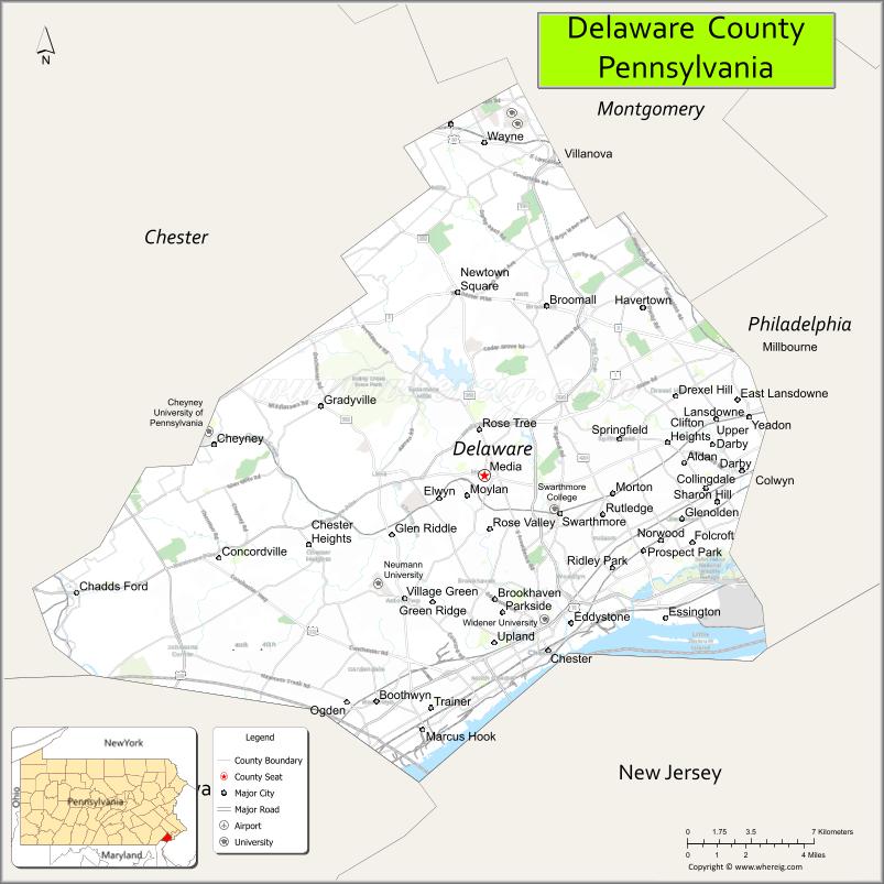
About Delaware County Map, Pennsylvania: The map showing the county boundary, county seat, major cities, highways, water bodies and neighbouring counties.
Pennsylvania Related Links
About Delaware County, Pennsylvania
Delaware County is a county located in the U.S. state of Pennsylvania. It's county seat is Media. As per 2020 census, the population of Delaware County is 573849 people and population density is square miles. According to the United States Census Bureau, the county has a total area of 191 sq mi (495 km2). Delaware County was established on 1789.
| Country | United States |
| State | Pennsylvania |
| Region | Southeastern Pennsylvania |
| County Seat | Media |
| Named After | Delaware River |
| Established | 1789 |
| Organized | 1789 |
| Coordinates | 39.9168° N, 75.3980° W |
| Total Area | 191 sq mi |
| Land Area | 184 sq mi |
| Water Area | 7 sq mi |
| Population (2020 Census) | 576,830 |
| Population Rank | Fifth most populous county in Pennsylvania |
| Major City | Upper Darby |
| Main Industries | Healthcare, Education, Manufacturing, Transportation |
| Major Airport | Philadelphia International Airport (PHL) |
| Time Zone | Eastern Time (UTC−05:00) |
| Known For | Philadelphia suburbs, Historic communities, Transportation hubs |
| Website | https://www.delcopa.gov |
Top Attractions in Delaware County, Pennsylvania
- Longwood Gardens (nearby) – World-famous botanical gardens.
- Tyler Arboretum – Historic arboretum and trails.
- Ridley Creek State Park – Hiking, picnicking, and open space.
- Harrah’s Philadelphia Casino – Gaming and entertainment.
- Swarthmore College Campus – Scenic college grounds.
- Pennsylvania Veterans Museum – Military history exhibits.
- John Heinz National Wildlife Refuge (nearby) – Wetlands and birdwatching.
- Chester Waterfront – River views and development area.
- Delaware County Courthouse – Historic government building.
- Rose Tree Park – Outdoor concerts and events.
- Haverford College Arboretum – Walking paths and gardens.
- Historic Media Theatre – Live performances and shows.
Cities & Towns in Delaware County, Pennsylvania
Chester, Upper Darby, Drexel Hill, Lansdowne, Collingdale, Folcroft, Havertown, Swarthmore, Media, Ridley Park, Eddystone, Marcus Hook, Sharon Hill, Glenolden, Yeadon, Radnor, Springfield, Morton, Springfield Township
- Adams County Map
- Allegheny County Map
- Armstrong County Map
- Beaver County Map
- Bedford County Map
- Berks County Map
- Blair County Map
- Bradford County Map
- Bucks County Map
- Butler County Map
- Cambria County Map
- Cameron County Map
- Carbon County Map
- Centre County Map
- Chester County Map
- Clarion County Map
- Clearfield County Map
- Clinton County Map
- Columbia County Map
- Crawford County Map
- Cumberland County Map
- Dauphin County Map
- Delaware County Map
- Elk County Map
- Erie County Map
- Fayette County Map
- Forest County Map
- Franklin County Map
- Fulton County Map
- Greene County Map
- Huntingdon County Map
- Indiana County Map
- Jefferson County Map
- Juniata County Map
- Lackawanna County Map
- Lancaster County Map
- Lawrence County Map
- Lebanon County Map
- Lehigh County Map
- Luzerne County Map
- Lycoming County Map
- McKean County Map
- Mercer County Map
- Mifflin County Map
- Monroe County Map
- Montgomery County Map
- Montour County Map
- Northampton County Map
- Northumberland County Map
- Perry County Map
- Philadelphia County Map
- Pike County Map
- Potter County Map
- Schuylkill County Map
- Snyder County Map
- Somerset County Map
- Sullivan County Map
- Susquehanna County Map
- Tioga County Map
- Union County Map
- Venango County Map
- Warren County Map
- Washington County Map
- Wayne County Map
- Westmoreland County Map
- Wyoming County Map
- York County Map
- Alabama Counties
- Alaska boroughs
- Arizona Counties
- Arkansas Counties
- California County Map
- Colorado Counties
- Connecticut Counties
- Delaware Counties
- Florida County Map
- Georgia County Map
- Hawaii Counties
- Idaho Counties
- Illinois Counties
- Indiana Counties
- Iowa Counties
- Kansas Counties
- Kentucky Counties
- Louisiana Counties
- Maine Counties
- Maryland Counties
- Massachusetts Counties
- Michigan County Map
- Minnesota Counties
- Mississippi Counties
- Missouri Counties
- Montana Counties
- Nebraska Counties
- Nevada Counties
- New York Counties
- New Hampshire Counties
- New Jersey Counties
- New Mexico Counties
- North Carolina Counties
- North Dakota Counties
- Ohio County Map
- Oklahoma Counties
- Oregon Counties
- Pennsylvania Counties
- Rhode Island Counties
- South Carolina Counties
- South Dakota Counties
- Map of Tennessee
- Texas County Map
- Utah Counties
- Vermont Counties
- Virginia Counties
- Washington Counties
- West Virginia Counties
- Wisconsin Counties
- Wyoming Counties