Written and Fact-checked by Whereig Editors | Updated On: May 01, 2026, 13:37 ET
Map of Adams County - Adams County is a county located in the U.S. state of Pennsylvania. Adams County Map showing cities, highways, important places and water bodies. Get Where is Adams County located in the map, major cities in Adams county, population, areas, and places of interest.
Map of Adams County, Pennsylvania
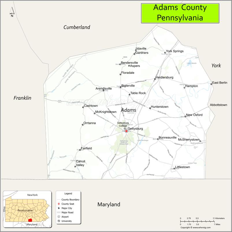
About Adams County Map, Pennsylvania: The map showing the county boundary, county seat, major cities, highways, water bodies and neighbouring counties.
Pennsylvania Related Links
About Adams County, Pennsylvania
Adams County is a county located in the U.S. state of Pennsylvania. It's county seat is Gettysburg. As per 2020 census, the population of Adams County is 104127 people and population density is square miles. According to the United States Census Bureau, the county has a total area of 522 sq mi (1,352 km2). Adams County was established on 1800.
Facts about Adams County, Pennsylvania
| Country | United States |
| State | Pennsylvania |
| Region | South Central Pennsylvania |
| County Seat | Gettysburg |
| Named After | John Adams |
| Established | 1800 |
| Organized | 1800 |
| Coordinates | 39.8721° N, 77.2160° W |
| Total Area | 522 sq mi |
| Land Area | 519 sq mi |
| Water Area | 3 sq mi |
| Population (2020 Census) | 102,627 |
| Population Rank | Mid-sized county in Pennsylvania |
| Major City | Gettysburg |
| Main Industries | Tourism, Agriculture, Manufacturing, Education |
| Major Airport | Gettysburg Regional Airport (W05) |
| Time Zone | Eastern Time (UTC−05:00) |
| Known For | Gettysburg Battlefield, Civil War history, Gettysburg Address |
| Website | https://www.adamscountypa.gov |
Top Attractions in Adams County, Pennsylvania
- Gettysburg National Military Park – Famous Civil War battlefield.
- Gettysburg National Cemetery – Lincoln’s Gettysburg Address site.
- Gettysburg Museum of the American Civil War – Interactive history exhibits.
- Eisenhower National Historic Site – Dwight D. Eisenhower’s home.
- Gettysburg Downtown Historic District – Shops, dining, and history.
- Devil’s Den – Iconic battlefield rock formations.
- Little Round Top – Scenic battlefield overlook.
- Sachs Covered Bridge – Historic wooden bridge.
- Adams County Winery – Local wine tasting.
- Mister Ed’s Elephant Museum & Candy Emporium – Quirky family attraction.
- National Apple Museum – Apple industry history.
- Gettysburg Ghost Tours – Historic nighttime walking tours.
Cities & Towns in Adams County, Pennsylvania
Gettysburg, Abbottstown, Bonneauville, Biglerville, Bendersville, Carroll Valley, Fairfield, East Berlin, York Springs, New Oxford, Littlestown, Arendtsville, Straban, Aspers
- Adams County Map
- Allegheny County Map
- Armstrong County Map
- Beaver County Map
- Bedford County Map
- Berks County Map
- Blair County Map
- Bradford County Map
- Bucks County Map
- Butler County Map
- Cambria County Map
- Cameron County Map
- Carbon County Map
- Centre County Map
- Chester County Map
- Clarion County Map
- Clearfield County Map
- Clinton County Map
- Columbia County Map
- Crawford County Map
- Cumberland County Map
- Dauphin County Map
- Delaware County Map
- Elk County Map
- Erie County Map
- Fayette County Map
- Forest County Map
- Franklin County Map
- Fulton County Map
- Greene County Map
- Huntingdon County Map
- Indiana County Map
- Jefferson County Map
- Juniata County Map
- Lackawanna County Map
- Lancaster County Map
- Lawrence County Map
- Lebanon County Map
- Lehigh County Map
- Luzerne County Map
- Lycoming County Map
- McKean County Map
- Mercer County Map
- Mifflin County Map
- Monroe County Map
- Montgomery County Map
- Montour County Map
- Northampton County Map
- Northumberland County Map
- Perry County Map
- Philadelphia County Map
- Pike County Map
- Potter County Map
- Schuylkill County Map
- Snyder County Map
- Somerset County Map
- Sullivan County Map
- Susquehanna County Map
- Tioga County Map
- Union County Map
- Venango County Map
- Warren County Map
- Washington County Map
- Wayne County Map
- Westmoreland County Map
- Wyoming County Map
- York County Map
- Alabama Counties
- Alaska boroughs
- Arizona Counties
- Arkansas Counties
- California County Map
- Colorado Counties
- Connecticut Counties
- Delaware Counties
- Florida County Map
- Georgia County Map
- Hawaii Counties
- Idaho Counties
- Illinois Counties
- Indiana Counties
- Iowa Counties
- Kansas Counties
- Kentucky Counties
- Louisiana Counties
- Maine Counties
- Maryland Counties
- Massachusetts Counties
- Michigan County Map
- Minnesota Counties
- Mississippi Counties
- Missouri Counties
- Montana Counties
- Nebraska Counties
- Nevada Counties
- New York Counties
- New Hampshire Counties
- New Jersey Counties
- New Mexico Counties
- North Carolina Counties
- North Dakota Counties
- Ohio County Map
- Oklahoma Counties
- Oregon Counties
- Pennsylvania Counties
- Rhode Island Counties
- South Carolina Counties
- South Dakota Counties
- Map of Tennessee
- Texas County Map
- Utah Counties
- Vermont Counties
- Virginia Counties
- Washington Counties
- West Virginia Counties
- Wisconsin Counties
- Wyoming Counties