
Where is Biddeford Located? - Biddeford is a city located in the York County of Maine, United States. Biddeford lies between 43.48365 Degrees North latitudes and -70.4719 Degrees West longitudes.
Location Map of Biddeford, Maine
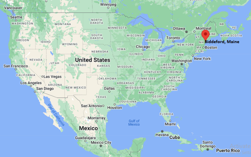
Biddeford Map, Maine, USA
Where is Biddeford?: The Google Map showing the location of Biddeford in the U.S. state of Maine.
Where is Biddeford Located?
Biddeford is a city located in the York County of Maine, United States. Biddeford lies between 43.48365 Degrees North latitude and -70.4719 Degrees West longitude. According to the 2020 U.S. Census, the population of Biddeford city is 22,552 people and the city has a total area of 59.081 sq mi. The city has numerous parks and recreational facilities.
Most Viewed US Maps
| USA Sttae Map | USA Region Map | USA Road Map |
| USA County Map | Where is USA in World Map? | US ZIP Code Map |
| USA Time Zones Map | US State and Capitals Map | USA Physical Map |
Find 4,400+ U.S. Cities by State - Explore Their Locations and Get Detailed Information
Biddeford, Maine Quick Facts
| Fact | Details |
|---|---|
| City | Biddeford |
| County | York County |
| State | Maine |
| State Capital | Augusta |
| Country | United States |
| US Region | Northeast |
| Latitude | 43.48365 N |
| Longitude | -70.4719 W |
| Elevation | 39 ft (12 m) |
| Land Area | 30.08 sq mi |
| Water Area | 3.83 sq mi |
| Total Area | 59.081 sq mi |
| Population (Census 2020) | 22,552 |
| Population Density | Approximately 750 per sq mi |
| ZIP Codes | 04005, 04006, 04007 |
| Area Code | 207 |
| Time Zone Standard | Eastern Standard Time (EST, UTC-5) |
| Time Zone Daylight | Eastern Daylight Time (EDT, UTC-4) |
| Currency | United States Dollar (USD) |
| FIPS Code | 23-06395 |
| Congressional District | Maine's 1st Congressional District |
Nearby Cities and Towns to Biddeford, Maine
- Saco, Maine - 2 mi North
- Old Orchard Beach, Maine - 5 mi Northeast
- Kennebunk, Maine - 8 mi Southwest
- Arundel, Maine - 9 mi West
- Scarborough, Maine - 13 mi Northeast
- Buxton, Maine - 15 mi North
- Portland, Maine - 20 mi Northeast
- Gorham, Maine - 21 mi North
- Wells, Maine - 16 mi Southwest
- South Portland, Maine - 22 mi Northeast
Biddeford, Maine Climate and Weather Overview
| Month | Avg High (°F) | Avg Low (°F) | Avg Rainfall (in) |
|---|---|---|---|
| January | 33 | 16 | 4.1 |
| April | 54 | 35 | 4.2 |
| July | 79 | 61 | 3.4 |
| October | 61 | 43 | 4.5 |
| Annual | 57 | 39 | 49.0 |
| Climate Attribute | Details |
|---|---|
| Climate Classification | Humid Continental (Köppen Dfb) |
| Annual Rainfall | Approximately 49 inches |
| Annual Sunshine Days | About 198 days |
| Hurricane/Tornado Risk | Low - Occasional coastal storms, nor'easters and winter snowstorms |
| Snowfall | Approximately 60 inches annually |
Driving Distances from Biddeford, Maine
| City | State | Distance (mi) | Approx. Drive Time |
|---|---|---|---|
| Saco | Maine | 2 | 5 min |
| Old Orchard Beach | Maine | 5 | 10 min |
| Kennebunk | Maine | 8 | 12 min |
| Arundel | Maine | 9 | 15 min |
| Scarborough | Maine | 13 | 20 min |
| Buxton | Maine | 15 | 22 min |
| Wells | Maine | 16 | 25 min |
| Portland | Maine | 20 | 30 min |
| Gorham | Maine | 21 | 30 min |
| South Portland | Maine | 22 | 32 min |
Transportation and Connectivity in Biddeford, Maine
| Transportation | Details |
|---|---|
| Airport Name | Portland International Jetport |
| IATA Code | PWM |
| Port | Port of Biddeford Pool |
| Major Highways | Interstate 95 (Maine Turnpike), U.S. Route 1, Maine State Route 9, Maine State Route 111 |
| Train Service | Amtrak Downeaster (Saco Transportation Center nearby) |
| Local Bus/Transit Service | Biddeford-Saco-Old Orchard Beach Transit (BSOOB Transit) |
- Interstate 95 (Maine Turnpike) provides direct access to Portland, Portsmouth, Boston and other communities throughout New England.
- U.S. Route 1 connects Biddeford with nearby coastal towns and southern Maine communities.
- Amtrak Downeaster service from the nearby Saco Transportation Center offers passenger rail service between Brunswick, Portland and Boston.
- Portland International Jetport is approximately 18 miles northeast of Biddeford and provides regular domestic air service.
Key Landmarks and Places to Visit in Biddeford, Maine
| Landmark | Type |
|---|---|
| Biddeford Mills Museum | History Museum |
| University of New England | University Campus |
| Fortunes Rocks Beach | Public Beach |
| Biddeford Pool | Coastal Village |
| Clifford Park | City Park |
| Rotary Park | Riverfront Park |
| Wood Island Lighthouse | Historic Lighthouse |
| Rachel Carson National Wildlife Refuge | Wildlife Refuge |
| Mechanics Park | Community Park |
| Saco River Walk | Scenic Riverfront Trail |
Colleges and Universities in Biddeford, Maine
| Institution | Type | Level | Notable For |
|---|---|---|---|
| University of New England | Private | University | Health sciences, medicine and marine research |
| Southern Maine Community College | Public | Community College | Career and technical education |
| University of Southern Maine | Public | University | Business, education and public service |
| York County Community College | Public | Community College | Workforce training and transfer programs |
| Saint Joseph's College of Maine | Private | College | Liberal arts, nursing and business |
| University of Maine | Public | Research University | Engineering, forestry and research |
Waterbodies in Biddeford, Maine
Saco River, Atlantic Ocean, Biddeford Pool, Little River, Goosefare Brook, Ferry Beach, Fortune's Rocks Beach, Hills Beach, Back Bay, Biddeford Harbor.
Golf Courses in Biddeford, Maine
Biddeford-Saco Country Club, Dutch Elm Golf Club, Dunegrass Golf Club, Cape Arundel Golf Club, Old Marsh Country Club, Nonesuch River Golf Club, Deep Brook Golf Course, Sanford Country Club.
Biddeford, Maine - Key Historical Facts
- Biddeford was first settled by European colonists in the early seventeenth century and was incorporated as a town in 1718 before becoming a city in 1855.
- The Saco River powered large textile mills during the nineteenth century, making Biddeford one of Maine's leading manufacturing centers.
- Immigrants from Canada, Ireland and other European countries contributed significantly to the city's industrial growth and cultural heritage.
- Following the decline of the textile industry, many historic mill buildings were restored and redeveloped for businesses, housing, education and cultural uses.
- The city's coastal location, beaches and nearby wildlife refuges have helped expand tourism and outdoor recreation.
- Today, Biddeford is known for its revitalized downtown, historic mill district, higher education, thriving local businesses and scenic Atlantic coastline.
References
- City of Biddeford
- U.S. Census Bureau
- University of New England
- Rachel Carson National Wildlife Refuge
Maine Related Maps and Info
| Maine Map | Maine County Map | Map of Maine With Cities |
| Maine Zipcodes | Airports in Maine | Where is Maine |
| Maine Area Codes | Maine Blank Map | Maine River Map |
| US County Map | Maine Physical Map | Maine Road Map |
- Where is Auburn
- Where is Augusta
- Where is Bangor
- Where is Bath
- Where is Belfast
- Where is Biddeford
- Where is Brewer
- Where is Brunswick
- Where is Bucksport
- Where is Calais
- Where is Camden
- Where is Cape Neddick
- Where is Caribou
- Where is Cumberland Center
- Where is Dover-Foxcroft
- Where is Ellsworth
- Where is Farmington
- Where is Gardiner
- Where is Gorham
- Where is Hallowell
- Where is Hampden
- Where is Houlton
- Where is Kennebunk
- Where is Kittery
- Where is Lake Arrowhead
- Where is Lewiston
- Where is Lisbon Falls
- Where is Madawaska
- Where is Millinocket
- Where is North Windham
- Where is Norway
- Where is Old Orchard Beach
- Where is Old Town
- Where is Orono
- Where is Pittsfield
- Where is Presque Isle
- Where is Rockland
- Where is Rumford
- Where is Saco
- Where is Skowhegan
- Where is South Eliot
- Where is South Portland
- Where is Topsham
- Where is Waterville
- Where is Westbrook
- Where is Winslow
- Where is Winthrop
- Where is Yarmouth
- Where is York Harbor