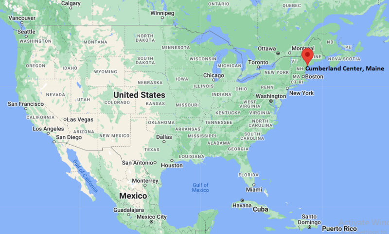
Where is Cumberland Center Located? - Cumberland Center is a city located in the Cumberland County of Maine, United States. Cumberland Center lies between 44.7973962 Degrees North latitudes and 93.5272861 Degrees West longitudes.
Location Map of Cumberland Center, Maine
Cumberland Center Map, Maine, USA
Where is Cumberland Center Located?
Cumberland Center is a city located in the Cumberland County of Maine, United States. Cumberland Center lies between 44.7973962 Degrees North latitudes and 93.5272861 Degrees West longitudes. According to 2020 U.S.census, the population of Cumberland Center city is 2739 people and the city has a total area of 4.23 sq mi. The city has numerous parks and recreational facilities.
Most Viewed US Maps
Cumberland Center, Maine Quick Facts
Field Value
Community Cumberland Center County Cumberland County State Maine State Capital Augusta US Region Northeastern United States Latitude 43.7967°N Longitude 70.2586°W Elevation ~220 ft (67 m) Land Area Not separately defined (village area within Cumberland) Water Area Included within town boundaries Total Area Part of Cumberland, Maine Population ~2,500 (approx. village area estimate) ZIP Code 04021 Area Code 207 Time Zone (Standard) Eastern Standard Time (EST) UTC -5 Time Zone (DST) Eastern Daylight Time (EDT) UTC -4 Currency US Dollar (USD)
Nearby Cities to Cumberland Center, Maine
Portland, Maine — 12 mi SouthFalmouth, Maine — 6 mi SouthYarmouth, Maine — 8 mi WestFreeport, Maine — 12 mi WestGray, Maine — 8 mi NorthWestbrook, Maine — 10 mi SouthWindham, Maine — 14 mi NorthwestBrunswick, Maine — 18 mi NortheastGorham, Maine — 15 mi SouthwestSouth Portland, Maine — 14 mi South
Cumberland Center, Maine Climate and Weather Overview
Month Avg High (°F) Avg Low (°F) Avg Rainfall (in)
January 31 12 3.5 April 52 33 3.8 July 79 59 3.6 October 58 41 4.1 Annual 55 38 47.0
Climate Attribute Value
Climate Classification (Köppen) Humid Continental (Dfb) Annual Snowfall ~60–70 inches Annual Rainfall ~45–50 inches Annual Sunshine Days ~180–190 days Winter Severity Cold, snowy winters
Driving Distances from Cumberland Center, Maine
City State Distance (mi) Approx. Drive Time
Portland ME 12 20 min Augusta ME 40 45 min Brunswick ME 18 25 min Freeport ME 12 20 min Lewiston ME 35 40 min Biddeford ME 35 40 min South Portland ME 14 25 min Falmouth ME 6 10 min Yarmouth ME 8 12 min Windham ME 14 20 min
Transportation and Connectivity in Cumberland Center, Maine
Mode Details
Airport Portland International Jetport (PWM) Port Port of Portland (Casco Bay access) Major Highways I-95, US-1, ME-9 Rail/Amtrak Amtrak Downeaster (Portland Station) Local Transit Regional bus service via Greater Portland METRO
I-95 — main interstate connecting Cumberland County to Boston and northern Maine
US-1 — coastal route linking Portland, Freeport, and coastal towns
ME-9 — regional connector road through Cumberland area
Key Landmarks and Places to Visit in Cumberland Center, Maine
Landmark Name Type
Cumberland Farmers Club Community Landmark Cumberland Town Hall Government Building Val Halla Golf Course Golf Course Cumberland Commons Recreation Area Prince Memorial Library (nearby Cumberland) Library Greely High School Campus Educational Campus Cumberland Fairgrounds Event Grounds Royal River Park (nearby Yarmouth) Riverfront Park
Places to Visit in Cumberland Center, Maine
Landmark Name Type
Winn Road Conservation Area Nature Preserve Broad Cove Reserve (nearby) Coastal Nature Area Littlejohn Island Scenic Area (nearby) Island / Scenic View Pineland Farms (nearby New Gloucester) Farm & Recreation Casco Bay Islands (regional access) Island Chain Fort Williams Park (Cape Elizabeth, regional) Coastal Park Portland Head Light (regional) Lighthouse Old Port District (Portland) Historic Waterfront
Colleges and Universities in Cumberland Center, Maine
Institution Name Type Level Notable For
University of Southern Maine (Portland) Public University Liberal arts & professional studies Bowdoin College (Brunswick) Private University Elite liberal arts college Southern Maine Community College Public Community College Career training & technical programs
Waterbodies in Cumberland Center, Maine
Cumberland River (regional), Casco Bay, Highland Lake (nearby), Broad Cove, Royal River
Golf Courses in Cumberland Center, Maine
Val Halla Golf Course, Toddy Brook Golf Course (nearby), Falmouth Country Club (nearby), Freeport Country Club (regional)
Cumberland Center, Maine - Key Historical Facts
Cumberland Center developed as the historic civic hub of the town of Cumberland in the 18th century.
The area grew around early farming communities and local trade routes in southern Maine.
It served as an important inland settlement supporting coastal towns like Portland and Yarmouth.
The town’s agricultural heritage influenced its early economy and land use patterns.
Many historic buildings and community institutions still reflect its colonial-era roots.
Today it remains a quiet residential village within the Greater Portland metropolitan area.
References
Maine Related Maps and Info
Location Map of Maine Cities
Popular US Cities
About USA
US Counties
World Countries
World Cup 2026