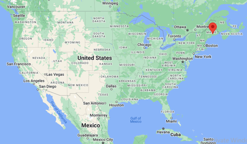
Where is Bucksport Located? - Bucksport is a city located in the Hancock County of Maine, United States. Bucksport lies between 44.60155 Degrees North latitudes and -68.7768 Degrees West longitudes.
Location Map of Bucksport, Maine
Bucksport Map, Maine, USA
Where is Bucksport?: The Google Map showing the location of Bucksport in the U.S. state of Maine.
Where is Bucksport Located?
Bucksport is a town located in the Hancock County of Maine, United States. Bucksport lies between 44.60155 Degrees North latitude and -68.7768 Degrees West longitude. According to the 2020 U.S. Census, the population of Bucksport town is 2,832 people and the town has a total area of 56.85 sq mi. The town has numerous parks and recreational facilities.
Transportation and Connectivity in Bucksport, Maine
Transportation
Details
Airport Name
Bangor International Airport
IATA Code
BGR
Port
Port of Bucksport
Major Highways
US 1, Maine State Route 3, Maine State Route 46, Maine State Route 15
Train/Amtrak Service
No Amtrak service; nearest station at Brunswick
Local Bus/Transit Service
Downeast Community Partners regional transportation
US Route 1 - Main coastal highway connecting Bucksport with Ellsworth, Belfast and Midcoast Maine.
Maine State Route 3 - Provides direct access to Bangor and Mount Desert Island.
Maine State Route 15 - Connects Bucksport with Brewer and inland communities.
Maine State Route 46 - Links the town with Dedham and nearby rural areas.
Penobscot Narrows Bridge approach roads - Provide convenient access across the Penobscot River to Verona Island and Prospect.
Key Landmarks and Places to Visit in Bucksport, Maine
Landmark Name
Type
Penobscot Narrows Bridge and Observatory
Observation Tower
Fort Knox State Historic Site
Historic Site
Bucksport Waterfront Walkway
Riverfront Park
Buck Memorial Library
Historic Library
Bucksport Historical Society Museum
Museum
Silver Lake
Recreation Area
Main Street Historic District
Historic District
Sandy Point Beach
Beach
Fort Point State Park
State Park
Verona Island Trails
Nature Area
Colleges and Universities in Bucksport, Maine
Institution Name
Type
Level
Notable For
University of Maine
Public
University
Flagship research university
Eastern Maine Community College
Public
Community College
Technical and workforce education
Husson University
Private
University
Business and healthcare programs
University of Maine at Augusta - Bangor Center
Public
University
Adult and online education
Regional School Unit 25
Public
K-12 District
Public education services
Waterbodies in Bucksport, Maine
Penobscot River, Penobscot Bay, Silver Lake, Alamoosook Lake, Toddy Pond, Narramissic River, Marsh Stream, Bagaduce River
Golf Courses in Bucksport, Maine
Bucksport Golf Club, Lucerne Golf Club, Rocky Knoll Country Club, Bangor Municipal Golf Course, Northport Golf Club, Castine Golf Club, Searsport Pines Golf Course, Winterport Golf Club
Bucksport, Maine - Key Historical Facts
Bucksport was incorporated in 1792 and was named after Colonel Jonathan Buck, one of the area's earliest settlers.
The town became an important shipbuilding and lumber center because of its location along the Penobscot River.
Paper manufacturing played a major role in the local economy for more than a century, with the Verso paper mill serving as one of the region's largest employers.
Fort Knox, completed in the mid-nineteenth century across the river, was built to protect the Penobscot River from potential naval attacks.
The Penobscot Narrows Bridge and Observatory, opened in 2006, became one of Maine's best-known engineering landmarks.
Today, Bucksport is recognized for its waterfront, historic downtown, outdoor recreation, and easy access to Maine's coastal attractions.