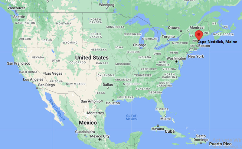
Where is Cape Neddick Located? - Cape Neddick is a city located in the York County of Maine, United States. Cape Neddick lies between 43.21332 Degrees North latitudes and -70.6397 Degrees West longitudes.
Location Map of Cape Neddick, Maine
Cape Neddick Map, Maine, USA
Where is Cape Neddick?: The Google Map showing the location of Cape Neddick in the U.S. state of Maine.
Where is Cape Neddick Located?
Cape Neddick is a city located in the York County of Maine, United States. Cape Neddick lies between 43.21332 Degrees North latitudes and -70.6397 Degrees West longitudes. According to 2020 U.S.census, the population of Cape Neddick city is 3037 people and the city has a total area of 3.965 sq mi. The city has numerous parks and recreational facilities.
Transportation and Connectivity in Cape Neddick, Maine
Transportation
Details
Airport Name
Portsmouth International Airport at Pease (nearest commercial airports also available in Portland and Boston)
IATA Code
PSM
Port
Cape Neddick Harbor
Major Highways
U.S. Route 1, Maine State Route 103, Interstate 95 (nearby)
Train/Amtrak Service
Nearest Amtrak Downeaster station in Wells
Local Bus/Transit Service
York County Community Action Corporation (YCCAC) transit services
U.S. Route 1 connects Cape Neddick with York, Ogunquit, Kittery, and other coastal communities.
Interstate 95, accessible a few miles inland, provides convenient travel to Portland, Portsmouth, and Boston.
The Amtrak Downeaster serves nearby Wells with rail connections to Portland and Boston.
Cape Neddick Harbor supports recreational boating and local fishing activities along Maine's southern coast.
The community is best known for its rugged Atlantic coastline, scenic viewpoints, and the iconic Nubble Lighthouse.
Key Landmarks and Places to Visit in Cape Neddick, Maine
Landmark Name
Type
Nubble Lighthouse (Cape Neddick Light Station)
Historic Lighthouse
Sohier Park
Scenic Oceanfront Park
Cape Neddick Beach
Beach
Mount Agamenticus Conservation Region
Nature Preserve
Long Sands Beach
Public Beach
Short Sands Beach
Public Beach
Ogunquit Museum of American Art
Art Museum
Marginal Way
Coastal Walking Trail
York's Wild Kingdom
Zoo and Amusement Park
Cape Neddick Harbor
Harbor
Colleges and Universities in Cape Neddick, Maine
Institution Name
Type
Level
Notable For
University of New Hampshire
Public
University
Research, engineering, marine sciences, and business
York County Community College
Public
Community College
Career training and associate degree programs
Southern Maine Community College
Public
Community College
Technical education and university transfer programs
University of Southern Maine
Public
University
Business, education, and health sciences
University of New England
Private
University
Health professions and marine sciences
Waterbodies in Cape Neddick, Maine
Atlantic Ocean, Cape Neddick Harbor, Cape Neddick River, Little River, York River, Gulf of Maine, Brave Boat Harbor, Ogunquit River
Golf Courses in Cape Neddick, Maine
The Ledges Golf Club, Cape Neddick Country Club, York Golf & Tennis Club, Old Marsh Country Club, Cape Arundel Golf Club, Dutch Elm Golf Course, Pease Golf Course, The Oaks Golf Links
Cape Neddick, Maine - Key Historical Facts
Cape Neddick was settled during the seventeenth century as part of the Town of York and developed around fishing, shipbuilding, and maritime trade.
Cape Neddick Light, commonly known as Nubble Lighthouse, was completed in 1879 to guide ships safely along Maine's rocky coastline.
The harbor has long supported commercial fishing, lobstering, and recreational boating, remaining an important part of the local economy.
During the late nineteenth and early twentieth centuries, Cape Neddick became a popular summer destination as visitors were drawn to its scenic coastline and cool Atlantic climate.
Nearby beaches, oceanfront parks, and coastal trails have helped establish the area as one of southern Maine's best-known vacation destinations.
Today, Cape Neddick is recognized for its picturesque lighthouse, rugged shoreline, outdoor recreation, and easy access to York and Ogunquit.