
Where is Boone Located? - Boone is a city located in the Boone County of Iowa, United States. Boone lies between 42.06935 Degrees North latitudes and -93.8781Degrees West longitudes.
Location Map of Boone, Iowa
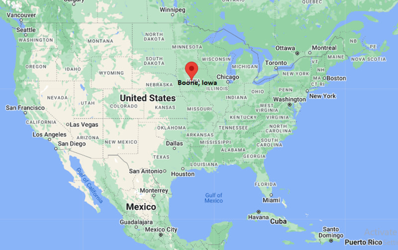
Boone Map, Iowa, USA
Where is Boone?: The Google Map showing the location of Boone in the U.S. state of Iowa.
Where is Boone Located?
Boone is a city located in the Boone County of Iowa, United States. Boone lies between 42.06935 Degrees North latitude and -93.8781Degrees West longitude. According to the 2020 U.S. Census, the population of Boone city is 12,460 people and the city has a total area of 9.087 sq mi. The city has numerous parks and recreational facilities.
Most Viewed US Maps
| USA Sttae Map | USA Region Map | USA Road Map |
| USA County Map | Where is USA in World Map? | US ZIP Code Map |
| USA Time Zones Map | US State and Capitals Map | USA Physical Map |
Find 4,400+ U.S. Cities by State - Explore Their Locations and Get Detailed Information
Boone, Iowa Quick Facts
| Fact | Details |
|---|---|
| City | Boone |
| County | Boone County |
| State | Iowa |
| State Capital | Des Moines |
| Country | United States |
| US Region | Midwest |
| Latitude | 42.06935 N |
| Longitude | -93.8781 W |
| Elevation | 1,135 ft (346 m) |
| Land Area | 9.087 sq mi |
| Water Area | 0.10 sq mi |
| Total Area | 9.087 sq mi |
| Population (Census 2020) | 12,460 |
| Population Density | Approximately 1,380 per sq mi |
| ZIP Code | 50036 |
| Area Code | 515 |
| Time Zone Standard | Central Standard Time (CST, UTC-6) |
| Time Zone Daylight | Central Daylight Time (CDT, UTC-5) |
| Currency | United States Dollar (USD) |
| FIPS Code | 19-07390 |
| Congressional District | Iowa's 4th Congressional District |
Nearby Cities and Towns to Boone, Iowa
- Madrid, Iowa - 11 mi Southeast
- Ogden, Iowa - 10 mi West
- Story City, Iowa - 23 mi East
- Ames, Iowa - 17 mi East
- Perry, Iowa - 18 mi Southwest
- Ankeny, Iowa - 36 mi Southeast
- Des Moines, Iowa - 49 mi Southeast
- Nevada, Iowa - 29 mi East
- Jefferson, Iowa - 35 mi West
- Fort Dodge, Iowa - 49 mi Northwest
Boone, Iowa Climate and Weather Overview
| Month | Avg High (°F) | Avg Low (°F) | Avg Precipitation (in) |
|---|---|---|---|
| January | 28 | 11 | 1.0 |
| April | 61 | 39 | 3.8 |
| July | 85 | 65 | 4.5 |
| October | 64 | 42 | 2.4 |
| Annual | 60 | 39 | 35.2 |
| Climate Attribute | Details |
|---|---|
| Climate Classification | Hot-Summer Humid Continental (Köppen Dfa) |
| Annual Precipitation | Approximately 35.2 inches |
| Annual Sunshine Days | About 202 days |
| Severe Weather Risk | Moderate - Thunderstorms, tornadoes, hail, winter snow and ice storms |
| Annual Snowfall | Approximately 33 inches |
Driving Distances from Boone, Iowa
| City | State | Distance (mi) | Approx. Drive Time |
|---|---|---|---|
| Ogden | Iowa | 10 | 12 min |
| Madrid | Iowa | 11 | 15 min |
| Ames | Iowa | 17 | 20 min |
| Perry | Iowa | 18 | 22 min |
| Story City | Iowa | 23 | 30 min |
| Nevada | Iowa | 29 | 35 min |
| Jefferson | Iowa | 35 | 40 min |
| Ankeny | Iowa | 36 | 40 min |
| Des Moines | Iowa | 49 | 55 min |
| Fort Dodge | Iowa | 49 | 55 min |
Transportation and Connectivity in Boone, Iowa
| Transportation | Details |
|---|---|
| Nearest Airport | Des Moines International Airport |
| IATA Code | DSM |
| Major Highways | U.S. Route 30, U.S. Route 169, Iowa Highway 17 |
| Rail Service | Union Pacific freight rail and Boone & Scenic Valley Railroad excursion service |
| Local Transit | Boone Area Transit and regional transportation services |
- U.S. Route 30 serves as the city's primary east-west highway, providing access to Ames, Denison and other Iowa communities.
- U.S. Route 169 connects Boone with Fort Dodge to the north and the Des Moines metropolitan area to the south.
- Des Moines International Airport, about 50 miles southeast, provides commercial flights to destinations across the United States.
- Boone & Scenic Valley Railroad offers heritage rail excursions and is one of Boone's most popular tourist attractions.
Key Landmarks and Places to Visit in Boone, Iowa
| Landmark | Type |
|---|---|
| Boone & Scenic Valley Railroad | Heritage Railroad |
| Bass Point Creek High Bridge | Historic Railroad Bridge |
| Ledges State Park | State Park |
| Boone County Historical Center | History Museum |
| McHose Park | City Park |
| Seven Oaks Recreation | Outdoor Recreation Area |
| Mamie Doud Eisenhower Birthplace | Historic House Museum |
| Boone Speedway | Auto Racing Track |
| Rail Explorers Iowa Division | Outdoor Attraction |
| Kate Shelley High Bridge Viewpoint | Scenic Viewpoint |
Colleges and Universities in Boone, Iowa
| Institution | Type | Level | Notable For |
|---|---|---|---|
| Des Moines Area Community College - Boone Campus | Public | Community College | Technical education, career training and transfer programs |
| Iowa State University | Public | Research University | Engineering, agriculture and veterinary medicine |
| Ellsworth Community College | Public | Community College | Career and technical education |
| Grinnell College | Private | College | Liberal arts and sciences |
| Drake University | Private | University | Law, pharmacy and business |
| Grand View University | Private | University | Business, nursing and liberal arts |
Waterbodies in Boone, Iowa
Des Moines River, Beaver Creek, Honey Creek, Squaw Creek, Bass Point Creek, Prairie Creek, Don Williams Lake, Ledges Creek, Bluff Creek, Saylorville Lake.
Golf Courses in Boone, Iowa
Boone Golf & Country Club, Cedar Pointe Golf Course, River Valley Golf Course, Jester Park Golf Course, Ames Golf & Country Club, Veenker Memorial Golf Course, Honey Creek Golf Club, Beaver Creek Golf Club.
Boone, Iowa - Key Historical Facts
- Boone was founded in 1865 and named after Captain Nathan Boone, a son of the American pioneer Daniel Boone.
- The arrival of the railroad transformed Boone into an important transportation and commercial center in central Iowa during the late nineteenth century.
- The city became well known for coal mining, agriculture and railroad operations, which supported its economy for many decades.
- Boone is home to the famous Boone & Scenic Valley Railroad and the nearby Kate Shelley High Bridge, one of the tallest and longest railroad bridges in the United States.
- Outdoor recreation expanded with the development of Ledges State Park and the Des Moines River valley, attracting visitors throughout the year.
- Today, Boone is recognized for its railroad heritage, scenic parks, recreational opportunities and its role as a regional center for Boone County.
References
Iowa Related Maps and Info
| Iowa Map | Iowa County Map | Iowa Cities Map |
| Iowa Zipcodes | Where is Iowa | Airports in Iowa |
| Iowa Area Codes | Iowa Blank Map | Iowa River Map |
| Iowa Physical Map | Iowa Road Map | Where is Where is Des Moines |
- Where is Altoona
- Where is Ames
- Where is Ankeny
- Where is Bettendorf
- Where is Bondurant
- Where is Boone
- Where is Burlington
- Where is Carroll
- Where is Cedar Falls
- Where is Cedar Rapids
- Where is Clinton
- Where is Clive
- Where is Coralville
- Where is Council Bluffs
- Where is Davenport
- Where is Denison
- Where is Dubuque
- Where is Fairfield
- Where is Fort Dodge
- Where is Fort Madison
- Where is Grimes
- Where is Grinnell
- Where is Indianola
- Where is Iowa City
- Where is Johnston
- Where is Keokuk
- Where is Le Mars
- Where is Marion
- Where is Marshalltown
- Where is Mason City
- Where is Mount Pleasant
- Where is Muscatine
- Where is Newton
- Where is North Liberty
- Where is Norwalk
- Where is Oskaloosa
- Where is Ottumwa
- Where is Pella
- Where is Perry
- Where is Pleasant Hill
- Where is Sioux Center
- Where is Sioux City
- Where is Spencer
- Where is Storm Lake
- Where is Urbandale
- Where is Waterloo
- Where is Waukee
- Where is Waverly
- Where is West Des Moines