
Where is Fairfield Located? - Fairfield is a city located in the Jefferson County of Iowa, United States. Fairfield lies between 32.6154 Degrees North latitudes and 93.2868 Degrees West longitudes.
Location Map of Fairfield, Iowa
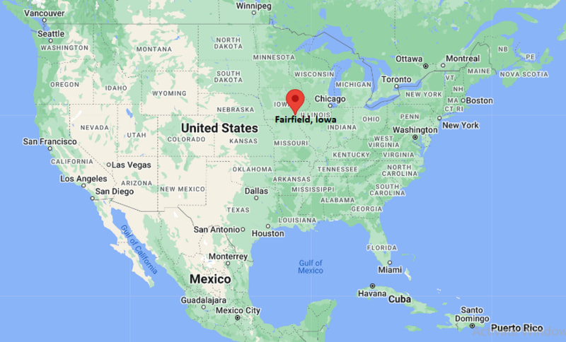
Fairfield Map, Iowa, USA
Where is Fairfield?: The Google Map showing the location of Fairfield in the U.S. state of Iowa.
Where is Fairfield Located?
Fairfield is a city located in the Jefferson County of Iowa, United States. Fairfield lies between 32.6154 Degrees North latitudes and 93.2868 Degrees West longitudes. According to 2020 U.S.census, the population of Fairfield city is 9416 people and the city has a total area of 6.54 sq mi. The city has numerous parks and recreational facilities.
Most Viewed US Maps
| USA Sttae Map | USA Region Map | USA Road Map |
| USA County Map | Where is USA in World Map? | US ZIP Code Map |
| USA Time Zones Map | US State and Capitals Map | USA Physical Map |
Find 4,400+ U.S. Cities by State - Explore Their Locations and Get Detailed Information
Fairfield, Iowa Quick Facts
| Property | Details |
|---|---|
| City | Fairfield |
| County | Jefferson County |
| State | Iowa |
| State Capital | Des Moines |
| US Region | Midwest |
| Latitude | 41.0079°N |
| Longitude | 91.9635°W |
| Elevation | ~740 ft (226 m) |
| Land Area | Approx. 6.5 sq mi |
| Water Area | Approx. 0.1 sq mi |
| Total Area | Approx. 6.6 sq mi |
| Population (2020 Census) | ~10,600 |
| Population Density | ~1,600 per sq mi |
| ZIP Codes | 52556 |
| Area Code | 641 |
| Time Zone Standard | Central Standard Time (CST), UTC−6 |
| Time Zone Daylight | Central Daylight Time (CDT), UTC−5 |
| Currency | US Dollar (USD) |
| FIPS Code | 19-26445 |
| Settlement Type | City |
Nearby Cities to Fairfield, Iowa
- Ottumwa, Iowa - West - 25 mi
- Washington, Iowa - East - 22 mi
- Mount Pleasant, Iowa - Southeast - 28 mi
- Keosauqua, Iowa - South - 20 mi
- Oskaloosa, Iowa - Northwest - 45 mi
- Burlington, Iowa - Southeast - 65 mi
- Cedar Rapids, Iowa - North - 95 mi
- Iowa City, Iowa - North - 70 mi
- Des Moines, Iowa - Northwest - 110 mi
- Kirksville, Missouri - South - 45 mi
Fairfield, Iowa Climate and Weather Overview
| Month | Avg High (°F) | Avg Low (°F) | Avg Rainfall (in) |
|---|---|---|---|
| January | 33 | 16 | 1.4 |
| April | 63 | 41 | 3.5 |
| July | 86 | 66 | 4.1 |
| October | 65 | 44 | 2.7 |
| Annual | 62 | 42 | ~38–40 |
| Climate Attribute | Details |
|---|---|
| Climate Classification (Köppen) | Humid continental (Dfa) |
| Annual Rainfall | About 38–40 inches |
| Summer Conditions | Hot, humid summers with thunderstorms |
| Winter Conditions | Cold winters with snow and ice |
| Severe Weather Risk | Tornadoes, thunderstorms, flooding, winter ice |
Driving Distances from Fairfield, Iowa
| City | State | Distance (mi) | Approx. Drive Time |
|---|---|---|---|
| Ottumwa | Iowa | 25 | 30 min |
| Washington | Iowa | 22 | 25 min |
| Mount Pleasant | Iowa | 28 | 30–35 min |
| Oskaloosa | Iowa | 45 | 50 min |
| Iowa City | Iowa | 70 | 1 hr 20 min |
| Cedar Rapids | Iowa | 95 | 1 hr 45 min |
| Des Moines | Iowa | 110 | 2 hr |
| Burlington | Iowa | 65 | 1 hr 15 min |
| Kirksville | Missouri | 45 | 55 min |
| Chicago | Illinois | 290 | 4 hr 45 min |
Transportation and Connectivity in Fairfield, Iowa
| Transportation | Details |
|---|---|
| Airport Name | Eastern Iowa Airport (CID) |
| Major Highways | US-34, IA-1, US-218 (nearby) |
| Rail Service | Freight rail only |
| Local Transit | Jefferson County Transit (limited service) |
| Regional Hub | Iowa City–Cedar Rapids corridor |
- Fairfield is a regional center in southeastern Iowa with strong agricultural roots.
- The city is known for its cultural diversity and educational institutions.
- It serves as a service hub for Jefferson County and surrounding rural areas.
- Downtown Fairfield has a preserved historic courthouse square.
Places to Visit in Fairfield, Iowa
| Landmark Name | Type |
|---|---|
| Maharishi International University Campus | University Campus |
| Fairfield Arts & Convention Center | Cultural Center |
| Central Park (Fairfield Square) | Public Park |
| Jefferson County Courthouse | Historic Building |
| Abundance Ecovillage | Community |
| Abby View Trail | Nature Trail |
| Lacey-Keosauqua State Park (nearby) | State Park |
| Neal Smith National Wildlife Refuge (regional) | Wildlife Refuge |
| Lake Darling State Park (nearby) | Recreation Area |
| Old Main Street Historic District | Historic District |
Colleges and Universities in Fairfield, Iowa
| Institution Name | Type | Level | Notable For |
|---|---|---|---|
| Maharishi International University | Private | University | Transcendental Meditation-based education, computer science |
| Indian Hills Community College (regional) | Public | Community College | Technical and transfer programs |
| University of Iowa (regional) | Public | University | Medicine, law, research |
| Iowa State University (regional) | Public | University | Engineering, agriculture, science |
| Southeastern Community College (regional) | Public | Community College | Workforce training and associate degrees |
| Fairfield Community School District | Public | K–12 District | Local education system |
| Fairfield High School | Public | High School | STEM and arts programs |
| Fairfield Middle School | Public | Middle School | Core academic curriculum |
Waterbodies in Fairfield, Iowa
Rock Creek, Cedar Creek, Skunk River (regional), Des Moines River Basin (regional), Lake Darling (nearby), Lake Wapello (regional), local reservoirs and farm ponds
Golf Courses in Fairfield, Iowa
Fairfield Golf & Country Club, Blue Top Ridge Golf Course (regional), Spirit Hollow Golf Course (nearby Burlington), Oskaloosa Country Club, Burlington Golf Club, Ottumwa Country Club, Lake McBride Golf Course (regional), Airport National Golf Course (regional)
Fairfield, Iowa — Key Historical Facts
- Fairfield was founded in 1839 and became the county seat of Jefferson County.
- The city developed around its courthouse square, which remains a focal point today.
- Railroads and agriculture shaped early economic growth in the 19th century.
- In the late 20th century, it became known for Maharishi International University.
- The city is recognized for its cultural diversity and alternative education influence.
- Today, Fairfield blends historic Midwestern roots with a strong educational and cultural identity.
References
Iowa Related Maps and Info
| Iowa Map | Iowa County Map | Iowa Cities Map |
| Iowa Zipcodes | Where is Iowa | Airports in Iowa |
| Iowa Area Codes | Iowa Blank Map | Iowa River Map |
| Iowa Physical Map | Iowa Road Map | Where is Where is Des Moines |
- Where is Altoona
- Where is Ames
- Where is Ankeny
- Where is Bettendorf
- Where is Bondurant
- Where is Boone
- Where is Burlington
- Where is Carroll
- Where is Cedar Falls
- Where is Cedar Rapids
- Where is Clinton
- Where is Clive
- Where is Coralville
- Where is Council Bluffs
- Where is Davenport
- Where is Denison
- Where is Dubuque
- Where is Fairfield
- Where is Fort Dodge
- Where is Fort Madison
- Where is Grimes
- Where is Grinnell
- Where is Indianola
- Where is Iowa City
- Where is Johnston
- Where is Keokuk
- Where is Le Mars
- Where is Marion
- Where is Marshalltown
- Where is Mason City
- Where is Mount Pleasant
- Where is Muscatine
- Where is Newton
- Where is North Liberty
- Where is Norwalk
- Where is Oskaloosa
- Where is Ottumwa
- Where is Pella
- Where is Perry
- Where is Pleasant Hill
- Where is Sioux Center
- Where is Sioux City
- Where is Spencer
- Where is Storm Lake
- Where is Urbandale
- Where is Waterloo
- Where is Waukee
- Where is Waverly
- Where is West Des Moines