
Where is Broken Bow Located? - Broken Bow is a city located in the Custer County of Nebraska, United States. Broken Bow lies between 41.41259 Degrees North latitudes and -99.6355 Degrees West longitudes.
Location Map of Broken Bow, Nebraska
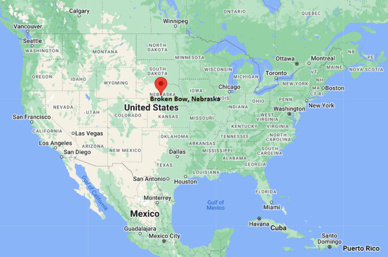
Broken Bow Map, Nebraska, USA
Where is Broken Bow?: The Google Map showing the location of Broken Bow in the U.S. state of Nebraska.
Where is Broken Bow Located?
Broken Bow is a city located in the Custer County of Nebraska, United States. Broken Bow lies between 41.41259 Degrees North latitude and -99.6355 Degrees West longitude. According to the 2020 U.S. Census, the population of Broken Bow city is 3,506 people and the city has a total area of 1.953 sq mi. The city has numerous parks and recreational facilities.
Most Viewed US Maps
| USA Sttae Map | USA Region Map | USA Road Map |
| USA County Map | Where is USA in World Map? | US ZIP Code Map |
| USA Time Zones Map | US State and Capitals Map | USA Physical Map |
Find 4,400+ U.S. Cities by State - Explore Their Locations and Get Detailed Information
Broken Bow, Nebraska Quick Facts
| Fact | Details |
|---|---|
| City | Broken Bow |
| County | Custer County |
| State | Nebraska |
| State Capital | Lincoln |
| Country | United States |
| US Region | Midwest |
| Latitude | 41.41259 N |
| Longitude | -99.6355 W |
| Elevation | 2,480 ft (756 m) |
| Land Area | approx. 3.1 sq mi |
| Water Area | approx. 0.0 sq mi |
| Total Area | approx. 1.953 sq mi |
| Population (Census 2020) | 3,506 |
| Population Density | Approximately 1,130 per sq mi |
| ZIP Code | 68822 |
| Area Code | 308 |
| Time Zone Standard | Central Standard Time (CST, UTC-6) |
| Time Zone Daylight | Central Daylight Time (CDT, UTC-5) |
| Currency | United States Dollar (USD) |
| FIPS Code | 31-05925 |
| Congressional District | Nebraska's 3rd Congressional District |
Nearby Cities and Towns to Broken Bow, Nebraska
- Sargent, Nebraska - 28 mi North
- Ansley, Nebraska - 20 mi East
- Callaway, Nebraska - 22 mi West
- Ansley, Nebraska - 20 mi East
- Merna, Nebraska - 15 mi Northwest
- Ansley, Nebraska - 20 mi East
- Litchfield, Nebraska - 30 mi Northeast
- Arnold, Nebraska - 32 mi Southwest
- Comstock, Nebraska - 18 mi West
- Ord, Nebraska - 45 mi Northeast
Broken Bow, Nebraska Climate and Weather Overview
| Month | Avg High (°F) | Avg Low (°F) | Avg Precipitation (in) |
|---|---|---|---|
| January | 35 | 13 | 0.5 |
| April | 62 | 35 | 1.8 |
| July | 90 | 63 | 2.7 |
| October | 65 | 38 | 1.2 |
| Annual | 61 | 39 | 22.5 |
| Climate Attribute | Details |
|---|---|
| Climate Classification | Cold semi-arid / humid continental transition |
| Annual Precipitation | Approximately 22.5 inches |
| Annual Snowfall | About 25–35 inches |
| Severe Weather Risk | Moderate - thunderstorms, hail, winter snow, occasional tornado risk |
| Annual Sunshine Days | About 220 days |
Driving Distances from Broken Bow, Nebraska
| City | State | Distance (mi) | Approx. Drive Time |
|---|---|---|---|
| Merna | Nebraska | 15 | 20 min |
| Ansley | Nebraska | 20 | 25 min |
| Callaway | Nebraska | 22 | 30 min |
| Sargent | Nebraska | 28 | 35 min |
| Arnold | Nebraska | 32 | 40 min |
| Ord | Nebraska | 45 | 55 min |
| Kearney | Nebraska | 55 | 1 hr |
| Grand Island | Nebraska | 80 | 1 hr 25 min |
| North Platte | Nebraska | 85 | 1 hr 30 min |
| Lincoln | Nebraska | 175 | 3 hr |
Transportation and Connectivity in Broken Bow, Nebraska
| Transportation | Details |
|---|---|
| Nearest Airport | Broken Bow Municipal Airport |
| IATA Code | BBW |
| Nearest Major Airport | Central Nebraska Regional Airport (Grand Island) |
| Major Highways | U.S. Route 2, Nebraska Highway 2, Nebraska Highway 92 |
| Rail Service | Freight rail only (BNSF regional lines) |
| Local Transit | No fixed city transit; regional rural transport only |
- U.S. Route 2 is the main east–west highway connecting Broken Bow to central and western Nebraska.
- Highway 92 provides regional access across central Nebraska communities.
- Broken Bow Municipal Airport serves general aviation and small aircraft operations.
- Grand Island airport is the closest commercial air hub for national travel.
Key Landmarks and Places to Visit in Broken Bow, Nebraska
| Landmark | Type |
|---|---|
| Custer County Museum | History Museum |
| Melham Park | City Park |
| Broken Bow Country Club | Golf Course |
| Broken Bow Public Library | Library |
| Downtown Broken Bow Historic Area | Historic District |
| Victoria Springs State Recreation Area (nearby) | State Recreation Area |
| Fort Hartsuff State Historical Park (regional) | State Historic Park |
| Calamus Reservoir (nearby) | Reservoir / Recreation Area |
| Sandhills Scenic Byway | Scenic Route |
| Cedar River Wildlife Management Area | Nature Area |
Colleges and Universities in Broken Bow, Nebraska
| Institution | Type | Level | Notable For |
|---|---|---|---|
| Central Community College (Grand Island campus nearby) | Public | Community College | Technical programs, associate degrees, workforce training |
| University of Nebraska at Kearney (regional) | Public | University | Education, business, health sciences |
| University of Nebraska–Lincoln | Public | Research University | Engineering, agriculture, business, law |
| Mid-Plains Community College | Public | Community College | Applied sciences and vocational training |
| Hastings College (regional) | Private | College | Liberal arts, education, sciences |
| Doane University (regional) | Private | University | Business, education, arts, sciences |
Waterbodies in Broken Bow, Nebraska
Middle Loup River, Calamus River, South Loup River, Victoria Creek, Plum Creek, Calamus Reservoir, Sherman Reservoir (regional), Davis Creek Reservoir, Cedar River (regional), Broken Bow Creek.
Golf Courses in Broken Bow, Nebraska
Broken Bow Country Club, Kearney Country Club (regional), Wild Horse Golf Club (nearby Gothenburg), Lakeside Country Club, Elks Country Club (North Platte region), Meadowlark Hills Golf Course (Kearney), Lake Maloney Golf Course, Ord Golf Club.
Broken Bow, Nebraska - Key Historical Facts
- Broken Bow was founded in the 1880s during the expansion of the Burlington Railroad through central Nebraska.
- The city was named after Broken Bow, Oklahoma, or possibly a broken bow discovered by settlers in the area.
- It became the county seat of Custer County and developed as a regional trade center.
- Early growth was driven by agriculture, cattle ranching, and railroad transport.
- The surrounding Nebraska Sandhills played a key role in shaping its ranching economy.
- Today, Broken Bow remains a small but important hub for agriculture and regional services in central Nebraska.
References
Other Nebraska Maps & Info
- Where is Alliance
- Where is Ashland
- Where is Auburn
- Where is Beatrice
- Where is Bellevue
- Where is Blair
- Where is Broken Bow
- Where is Central City
- Where is Chadron
- Where is Chalco
- Where is Cozad
- Where is Crete
- Where is Fairbury
- Where is Falls City
- Where is Fremont
- Where is Gering
- Where is Gothenburg
- Where is Grand Island
- Where is Gretna
- Where is Hastings
- Where is Holdrege
- Where is Kearney
- Where is La Vista
- Where is McCook
- Where is Minden
- Where is Nebraska City
- Where is North Platte
- Where is O'Neill
- Where is Offutt AFB
- Where is Ogallala
- Where is Papillion
- Where is Plattsmouth
- Where is Ralston
- Where is Schuyler
- Where is Scottsbluff
- Where is Seward
- Where is Sidney
- Where is South Sioux City
- Where is Valley
- Where is Wahoo
- Where is Waverly
- Where is Wayne
- Where is West Point
- Where is York