
Where is York Located? - York is a city located in the York County of Nebraska, United States. York lies between 43.1610946 Degrees North latitudes and 111.0164822 Degrees West longitudes.
Location Map of York, Nebraska
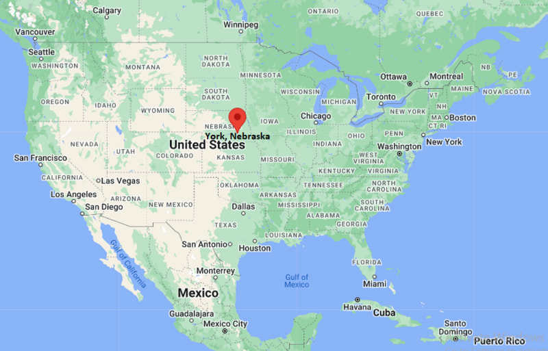
York Map, Nebraska, USA
Where is York?: The Google Map showing the location of York in the U.S. state of Nebraska.
Where is York Located?
York is a city located in the York County of Nebraska, United States. York lies between 43.1610946 Degrees North latitudes and 111.0164822 Degrees West longitudes. According to 2020 U.S.census, the population of York city is 8066 people and the city has a total area of 6.46 sq mi. The city has numerous parks and recreational facilities.
Most Viewed US Maps
| USA Sttae Map | USA Region Map | USA Road Map |
| USA County Map | Where is USA in World Map? | US ZIP Code Map |
| USA Time Zones Map | US State and Capitals Map | USA Physical Map |
Find 4,400+ U.S. Cities by State - Explore Their Locations and Get Detailed Information
York, Nebraska Quick Facts
| Attribute | Details |
|---|---|
| City | York |
| County | York County |
| State | Nebraska |
| State Capital | Lincoln |
| US Region | Midwestern United States |
| Latitude | 40.8681° N |
| Longitude | 97.5920° W |
| Elevation | Approximately 1,611 ft (491 m) |
| Land Area | 5.3 sq mi |
| Water Area | 0.0 sq mi |
| Total Area | 5.3 sq mi |
| Population (2020 Census) | 7,766 |
| Population Density | Approximately 1,465 per sq mi |
| ZIP Code | 68467 |
| Area Code | 402 |
| Time Zone Standard | Central Standard Time (CST), UTC−6 |
| Time Zone Daylight | Central Daylight Time (CDT), UTC−5 |
| Currency | United States Dollar (USD) |
| FIPS Code | 31-54835 |
| Community Type | City |
Transportation and Connectivity in York, Nebraska
| Transportation | Details |
|---|---|
| Airport Name | York Municipal Airport |
| IATA Code | JYR |
| Regional Airport | Lincoln Airport |
| Port | Not applicable (inland city) |
| Major Highways | Interstate 80, US Route 34, Nebraska Highway 81 |
| Train/Amtrak Service | Amtrak service available in nearby Hastings and Lincoln |
| Local Transit Service | Local community transportation services |
- Interstate 80 — Major east-west interstate connecting York with Lincoln, Omaha, and western Nebraska.
- US Route 34 — Regional highway connecting communities across central Nebraska.
- Nebraska Highway 81 — North-south route providing access through York County.
Top Places to Visit in York, Nebraska
| Landmark Name | Type |
|---|---|
| Wessels Living History Farm | Historical Farm Museum |
| York Area Children's Museum | Children's Museum |
| Clayton Museum of Ancient History | History Museum |
| Lee's Legendary Marbles and Collectibles | Collectibles Museum |
| Recharge Lake | Recreation Area |
| Holthus Convention Center | Event Venue |
| York Country Club | Golf Facility |
| Harrison Park | Community Park |
| York Opera House | Historic Theater |
| Four Corners Health Department Area | Community Landmark |
Driving Distances from York, Nebraska to Nearby Cities
| City | State | Distance (mi) | Approx. Drive Time |
|---|---|---|---|
| Hastings | Nebraska | 35 mi | 40 minutes |
| Grand Island | Nebraska | 45 mi | 45 minutes |
| Lincoln | Nebraska | 55 mi | 1 hour |
| Kearney | Nebraska | 95 mi | 1 hour 30 minutes |
| Omaha | Nebraska | 120 mi | 2 hours |
| North Platte | Nebraska | 150 mi | 2 hours 15 minutes |
| Sioux City | Iowa | 160 mi | 2 hours 45 minutes |
| Des Moines | Iowa | 220 mi | 3 hours 30 minutes |
| Kansas City | Missouri | 220 mi | 3 hours 30 minutes |
| Denver | Colorado | 420 mi | 6 hours |
Colleges and Universities Near York, Nebraska
| Institution Name | Type | Level | Notable For |
|---|---|---|---|
| York University | Private | University | Liberal arts, education, business, science, and Christian studies programs |
| Central Community College - Hastings Campus | Public | Community College | Technical training, career education, and transfer programs |
| University of Nebraska-Lincoln | Public | University | Agriculture, engineering, business, research, and sciences |
| Doane University | Private | University | Liberal arts, business, education, and professional programs |
| York Public Schools | Public | K–12 District | Local public education |
Waterbodies Near York, Nebraska
Recharge Lake, West Fork Big Blue River, Beaver Creek, and nearby central Nebraska waterways
Golf Courses and Stadiums Near York
Golf Courses: York Country Club and nearby central Nebraska golf facilities. Stadiums: York High School athletic facilities, York University sports facilities, and local community sports fields.
Key Landmarks and Places to Visit in York, Nebraska
| Landmark Name | Type |
|---|---|
| Wessels Living History Farm | Historical Farm Museum |
| Clayton Museum of Ancient History | History Museum |
| York Area Children's Museum | Children's Museum |
| York Opera House | Historic Theater |
| Holthus Convention Center | Event Venue |
| Recharge Lake | Recreation Area |
| Harrison Park | Community Park |
| York Historic Downtown | Historic District |
| York Country Club | Golf Facility |
| Lee's Legendary Marbles and Collectibles | Collectibles Museum |
York, Nebraska — Key Historical Facts
- The York area was originally inhabited by Native American groups of the Great Plains, including Pawnee and other Indigenous communities.
- European-American settlement began in the 1860s, and York County was organized in 1869.
- The city of York was founded in 1869 and named after York, Pennsylvania.
- The arrival of the railroad helped York grow as an agricultural trade and transportation center in central Nebraska.
- Agriculture, manufacturing, education, and local businesses have played important roles in York's economy.
- York became home to York University, founded in 1890, which has contributed to the city's educational heritage.
- Today, York is known for its small-town character, historic attractions, Interstate 80 access, agricultural heritage, and community events.
References
- United States Census Bureau
- City of York Official Website
- York County Official Website
- State of Nebraska Official Website
- Nebraska Tourism
Other Nebraska Maps & Info
- Where is Alliance
- Where is Ashland
- Where is Auburn
- Where is Beatrice
- Where is Bellevue
- Where is Blair
- Where is Broken Bow
- Where is Central City
- Where is Chadron
- Where is Chalco
- Where is Cozad
- Where is Crete
- Where is Fairbury
- Where is Falls City
- Where is Fremont
- Where is Gering
- Where is Gothenburg
- Where is Grand Island
- Where is Gretna
- Where is Hastings
- Where is Holdrege
- Where is Kearney
- Where is La Vista
- Where is McCook
- Where is Minden
- Where is Nebraska City
- Where is North Platte
- Where is O'Neill
- Where is Offutt AFB
- Where is Ogallala
- Where is Papillion
- Where is Plattsmouth
- Where is Ralston
- Where is Schuyler
- Where is Scottsbluff
- Where is Seward
- Where is Sidney
- Where is South Sioux City
- Where is Valley
- Where is Wahoo
- Where is Waverly
- Where is Wayne
- Where is West Point
- Where is York