
Where is Bellevue Located? - Bellevue is a city located in the Sarpy County of Nebraska, United States. Bellevue lies between 41.14966 Degrees North latitudes and -95.9099 Degrees West longitudes.
Location Map of Bellevue, Nebraska
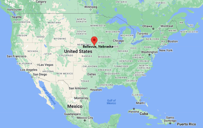
Bellevue Map, Nebraska, USA
Where is Bellevue?: The Google Map showing the location of Bellevue in the U.S. state of Nebraska.
Where is Bellevue Located?
Bellevue is a city located in the Sarpy County of Nebraska, United States. Bellevue lies at approximately 41.14966 Degrees North latitude and -95.9099 Degrees West longitude. According to the 2020 U.S. Census, the population of Bellevue city is 64,176 people and the city has a total area of 16.73 sq mi. The city has numerous parks and recreational facilities.
Most Viewed US Maps
| USA Sttae Map | USA Region Map | USA Road Map |
| USA County Map | Where is USA in World Map? | US ZIP Code Map |
| USA Time Zones Map | US State and Capitals Map | USA Physical Map |
Find 4,400+ U.S. Cities by State - Explore Their Locations and Get Detailed Information
Bellevue, Nebraska Quick Facts
| Fact | Details |
|---|---|
| City | Bellevue |
| County | Sarpy County |
| State | Nebraska |
| State Capital | Lincoln |
| Country | United States |
| US Region | Midwest |
| Latitude | 41.14966 N |
| Longitude | -95.9099 W |
| Elevation | 1,027 ft (313 m) |
| Land Area | 16.6 sq mi |
| Water Area | 0.4 sq mi |
| Total Area | 16.73 sq mi |
| Population (Census 2020) | 64,176 |
| Population Density | Approximately 3,867 per sq mi |
| ZIP Codes | 68005, 68123, 68147, 68157 |
| Area Code | 402, 531 |
| Time Zone Standard | Central Standard Time (CST, UTC-6) |
| Time Zone Daylight | Central Daylight Time (CDT, UTC-5) |
| Currency | United States Dollar (USD) |
| FIPS Code | 31-03950 |
| Congressional District | Nebraska's 2nd Congressional District |
Nearby Cities to Bellevue, Nebraska
- Papillion, Nebraska - 7 mi West
- La Vista, Nebraska - 9 mi Northwest
- Omaha, Nebraska - 10 mi North
- Ralston, Nebraska - 10 mi Northwest
- Council Bluffs, Iowa - 13 mi Northeast
- Plattsmouth, Nebraska - 18 mi South
- Gretna, Nebraska - 22 mi West
- Springfield, Nebraska - 15 mi Southwest
- Glenwood, Iowa - 23 mi East
- Fremont, Nebraska - 42 mi Northwest
Bellevue, Nebraska Climate and Weather Overview
| Month | Avg High (°F) | Avg Low (°F) | Avg Rainfall (in) |
|---|---|---|---|
| January | 34 | 15 | 0.8 |
| April | 64 | 41 | 3.2 |
| July | 88 | 67 | 4.0 |
| October | 66 | 42 | 2.2 |
| Annual | 63 | 41 | 31.4 |
| Climate Attribute | Details |
|---|---|
| Climate Classification | Hot Summer Humid Continental (Köppen Dfa) |
| Annual Rainfall | Approximately 31 inches |
| Annual Sunshine Days | About 214 days |
| Hurricane/Tornado Risk | Moderate - Tornadoes and severe thunderstorms during spring and summer |
| Snowfall | Approximately 28 inches annually |
Driving Distances from Bellevue, Nebraska
| City | State | Distance (mi) | Approx. Drive Time |
|---|---|---|---|
| Papillion | Nebraska | 7 | 12 min |
| La Vista | Nebraska | 9 | 15 min |
| Omaha | Nebraska | 10 | 18 min |
| Ralston | Nebraska | 10 | 18 min |
| Council Bluffs | Iowa | 13 | 20 min |
| Springfield | Nebraska | 15 | 20 min |
| Plattsmouth | Nebraska | 18 | 25 min |
| Gretna | Nebraska | 22 | 30 min |
| Glenwood | Iowa | 23 | 30 min |
| Fremont | Nebraska | 42 | 50 min |
Transportation and Connectivity in Bellevue, Nebraska
| Transportation | Details |
|---|---|
| Airport Name | Eppley Airfield |
| IATA Code | OMA |
| Port | Port of Omaha (nearby) |
| Major Highways | U.S. Highway 75, Nebraska Highway 370, Interstate 80 (nearby), Interstate 29 (nearby) |
| Train/Amtrak Service | Amtrak station in Omaha |
| Local Bus/Transit Service | Metro Transit Omaha |
- U.S. Highway 75 - Primary north-south highway connecting Bellevue with Omaha, Plattsmouth and southeastern Nebraska.
- Nebraska Highway 370 - Links Bellevue with Papillion, Gretna and western Sarpy County.
- Interstate 80 - Major east-west interstate located just north of the city, providing regional access across Nebraska and Iowa.
- Interstate 29 - Nearby interstate connecting the Omaha metropolitan area with Missouri, Iowa and the Upper Midwest.
Key Landmarks and Places to Visit in Bellevue, Nebraska
| Landmark | Type |
|---|---|
| Fontenelle Forest | Nature Preserve |
| Bellevue Berry and Pumpkin Ranch | Family Attraction |
| Sarpy County Museum | Museum |
| American Heroes Park | Memorial Park |
| Haworth Park | City Park |
| Washington Park | Historic Park |
| Olde Towne Bellevue | Historic District |
| Offutt Air Force Base Museum Area | Military Attraction |
| Henry Doorly Zoo and Aquarium | Zoo |
| Lauritzen Gardens | Botanical Garden |
Colleges and Universities in Bellevue, Nebraska
| Institution | Type | Level | Notable For |
|---|---|---|---|
| Bellevue University | Private | University | Online and adult education |
| Metropolitan Community College | Public | Community College | Career and technical programs |
| University of Nebraska Omaha | Public | University | Business and research |
| Creighton University | Private | University | Health sciences and law |
| College of Saint Mary | Private | University | Healthcare and liberal arts |
| Iowa Western Community College | Public | Community College | Workforce and transfer education |
Waterbodies in Bellevue, Nebraska
Missouri River, Papillion Creek, Big Papillion Creek, Bellevue Lake, Hanson Lake, Glenn Cunningham Lake, Carter Lake, Platte River, Twin Lakes, Walnut Creek.
Golf Courses in Bellevue, Nebraska
Tregaron Golf Course, Eagle Hills Golf Course, Willow Lakes Golf Course, Tara Hills Golf Course, Johnny Goodman Golf Course, Pacific Springs Golf Club, Quarry Oaks Golf Club, Tiburon Golf Club.
Bellevue, Nebraska - Key Historical Facts
- Bellevue was founded in the 1830s and is recognized as Nebraska's oldest continuous settlement.
- The city served as an important trading post and missionary center during the early years of westward expansion.
- Bellevue briefly served as the capital of the Nebraska Territory before the government moved to Omaha.
- Offutt Air Force Base, located just south of the city, became one of the nation's most important military installations and is home to U.S. Strategic Command.
- The growth of Bellevue accelerated after World War II as military personnel and families settled in the area.
- Today, Bellevue is a thriving suburban community within the Omaha metropolitan area, known for its historic heritage, educational institutions and strong military connections.
References
Other Nebraska Maps & Info
- Where is Alliance
- Where is Ashland
- Where is Auburn
- Where is Beatrice
- Where is Bellevue
- Where is Blair
- Where is Broken Bow
- Where is Central City
- Where is Chadron
- Where is Chalco
- Where is Cozad
- Where is Crete
- Where is Fairbury
- Where is Falls City
- Where is Fremont
- Where is Gering
- Where is Gothenburg
- Where is Grand Island
- Where is Gretna
- Where is Hastings
- Where is Holdrege
- Where is Kearney
- Where is La Vista
- Where is McCook
- Where is Minden
- Where is Nebraska City
- Where is North Platte
- Where is O'Neill
- Where is Offutt AFB
- Where is Ogallala
- Where is Papillion
- Where is Plattsmouth
- Where is Ralston
- Where is Schuyler
- Where is Scottsbluff
- Where is Seward
- Where is Sidney
- Where is South Sioux City
- Where is Valley
- Where is Wahoo
- Where is Waverly
- Where is Wayne
- Where is West Point
- Where is York