
Where is Papillion Located? - Papillion is a city located in the Sarpy County of Nebraska, United States. Papillion lies between 41.4549621 Degrees North latitudes and 106.8064263 Degrees West longitudes.
Location Map of Papillion, Nebraska
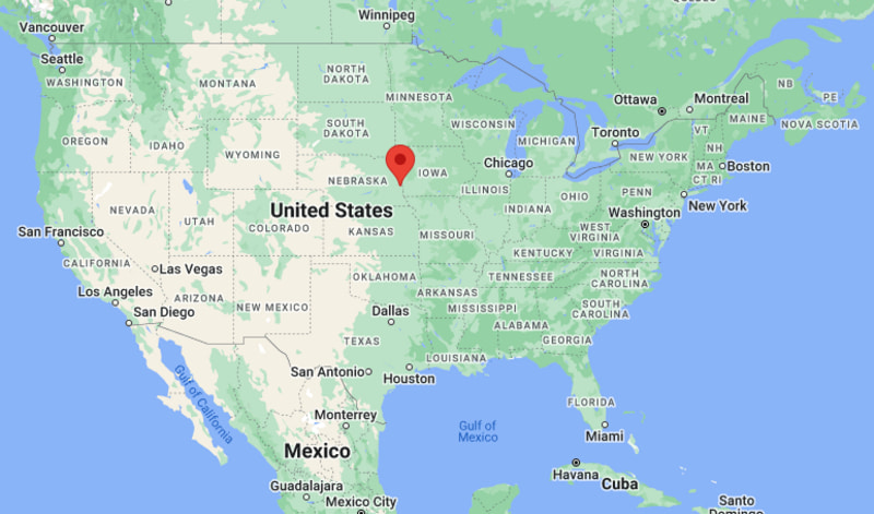
Papillion Map, Nebraska, USA
Where is Papillion?: The Google Map showing the location of Papillion in the U.S. state of Nebraska.
Where is Papillion Located?
Papillion is a city located in the Sarpy County of Nebraska, United States. Papillion lies between 41.4549621 Degrees North latitudes and 106.8064263 Degrees West longitudes. According to 2020 U.S.census, the population of Papillion city is 24159 people and the city has a total area of 9.87 sq mi. The city has numerous parks and recreational facilities.
Most Viewed US Maps
| USA Sttae Map | USA Region Map | USA Road Map |
| USA County Map | Where is USA in World Map? | US ZIP Code Map |
| USA Time Zones Map | US State and Capitals Map | USA Physical Map |
Find 4,400+ U.S. Cities by State - Explore Their Locations and Get Detailed Information
Papillion, Nebraska Quick Facts
| Attribute | Details |
|---|---|
| City | Papillion |
| County | Sarpy County |
| State | Nebraska |
| State Capital | Lincoln |
| US Region | Midwestern United States (West North Central) |
| Latitude | 41.1544° N |
| Longitude | 96.0422° W |
| Elevation | 1,109 ft (338 m) |
| Land Area | 11.98 sq mi |
| Water Area | 0.07 sq mi |
| Total Area | 12.05 sq mi |
| Population (2020 Census) | 24,159 |
| Population Density | Approximately 2,017 people per sq mi |
| ZIP Codes | 68046 |
| Area Code | 402, 531 |
| Time Zone Standard | Central Standard Time (CST, UTC−6) |
| Time Zone Daylight | Central Daylight Time (CDT, UTC−5) |
| Currency | United States Dollar (USD) |
| FIPS Code | 31-38250 |
| Congressional District | Nebraska's 2nd Congressional District |
Transportation and Connectivity in Papillion, Nebraska
| Category | Details |
|---|---|
| Airport Name | Eppley Airfield |
| IATA Code | OMA |
| Port | No commercial port |
| Major Highways | Nebraska Highway 370, Nebraska Highway 50, Interstate 80 (nearby), U.S. Route 75 (nearby) |
| Train/Amtrak Service | Nearest Amtrak station in Omaha |
| Local Bus/Transit Service | METRO Transit (Omaha Metro area) |
- Nebraska Highway 370 – Main east–west route connecting Papillion with Bellevue, Gretna, and Interstate 80.
- Nebraska Highway 50 – North–south highway linking Papillion with Springfield, Omaha, and surrounding Sarpy County communities.
- Interstate 80 – Located just north of the city, providing regional access to Lincoln, Omaha, Des Moines, and western Nebraska.
- U.S. Route 75 – Nearby expressway connecting Papillion with downtown Omaha, Bellevue, and southeastern Nebraska.
Top Places to Visit in Papillion, Nebraska
| Landmark Name | Type |
|---|---|
| Halleck Park | Community Park |
| Papio Bay Aquatic Center | Water Park |
| Werner Park | Baseball Stadium |
| Walnut Creek Recreation Area | Recreation Area |
| Sumtur Amphitheater | Outdoor Performance Venue |
| Shadow Lake Towne Center | Shopping Center |
| Sarpy County Museum | Museum |
| Chalco Hills Recreation Area | Nature Park |
| Fontenelle Forest | Nature Preserve |
| Bellevue Berry Farm | Family Attraction |
Driving Distances from Papillion, Nebraska to Nearby Cities
| City | State | Distance (mi) | Approx. Drive Time |
|---|---|---|---|
| Bellevue | Nebraska | 6 | 10 minutes |
| La Vista | Nebraska | 4 | 10 minutes |
| Omaha | Nebraska | 11 | 20 minutes |
| Ralston | Nebraska | 8 | 15 minutes |
| Gretna | Nebraska | 12 | 20 minutes |
| Springfield | Nebraska | 10 | 15 minutes |
| Council Bluffs | Iowa | 18 | 25 minutes |
| Lincoln | Nebraska | 52 | 1 hour |
| Fremont | Nebraska | 46 | 55 minutes |
| Nebraska City | Nebraska | 48 | 1 hour |
Colleges and Universities in Papillion, Nebraska
| Institution Name | Type | Level | Notable For |
|---|---|---|---|
| Bellevue University | Private | University | Adult and online degree programs |
| University of Nebraska at Omaha | Public | University | Research and professional education |
| Metropolitan Community College | Public | Community College | Career and transfer programs |
| College of Saint Mary | Private | University | Health sciences and liberal arts |
| Papillion La Vista Community Schools | Public | K–12 District | Primary and secondary education |
Waterbodies in Papillion, Nebraska
Papillion Creek, Big Papillion Creek, West Papillion Creek, Walnut Creek Lake, Chalco Hills Lake, Wehrspann Lake, Platte River, Missouri River, Standing Bear Lake, Glenn Cunningham Lake
Stadiums in Papillion
Werner Park, Papillion Landing Field House, Papillion-La Vista South High School Stadium, Papillion-La Vista High School Stadium, Tiburon Golf Club, Tara Hills Golf Course, Eagle Hills Golf Course
Papillion, Nebraska — Key Historical Facts
- Papillion was founded in 1870 along the route of the Burlington and Missouri River Railroad, which helped establish the community as a regional trade center.
- The city became the county seat of Sarpy County, strengthening its role as an administrative and commercial hub in eastern Nebraska.
- Its name comes from the French word papillon, meaning "butterfly," inspired by early French explorers who named Papillion Creek.
- Rapid suburban growth after World War II transformed Papillion into one of the fastest-growing communities in the Omaha metropolitan area.
- Today, Papillion is known for its excellent schools, parks, family-friendly neighborhoods, and Werner Park, home of the Omaha Storm Chasers baseball team.
References
- City of Papillion
- Sarpy County Government
- U.S. Census Bureau
- Bellevue University
- Omaha Storm Chasers – Werner Park
Other Nebraska Maps & Info
- Where is Alliance
- Where is Ashland
- Where is Auburn
- Where is Beatrice
- Where is Bellevue
- Where is Blair
- Where is Broken Bow
- Where is Central City
- Where is Chadron
- Where is Chalco
- Where is Cozad
- Where is Crete
- Where is Fairbury
- Where is Falls City
- Where is Fremont
- Where is Gering
- Where is Gothenburg
- Where is Grand Island
- Where is Gretna
- Where is Hastings
- Where is Holdrege
- Where is Kearney
- Where is La Vista
- Where is McCook
- Where is Minden
- Where is Nebraska City
- Where is North Platte
- Where is O'Neill
- Where is Offutt AFB
- Where is Ogallala
- Where is Papillion
- Where is Plattsmouth
- Where is Ralston
- Where is Schuyler
- Where is Scottsbluff
- Where is Seward
- Where is Sidney
- Where is South Sioux City
- Where is Valley
- Where is Wahoo
- Where is Waverly
- Where is Wayne
- Where is West Point
- Where is York