Written and Fact-checked by Whereig Editors, Reviewed by Mukesh Kumar| Last Updated On: May 10, 2026
Map of Sarpy County - Sarpy County is a county located in the U.S. state of Nebraska. Sarpy County Map showing cities, highways, important places and water bodies. Get Where is Sarpy County located in the map, major cities in Sarpy county, population, areas, and places of interest.
Map of Sarpy County, Nebraska
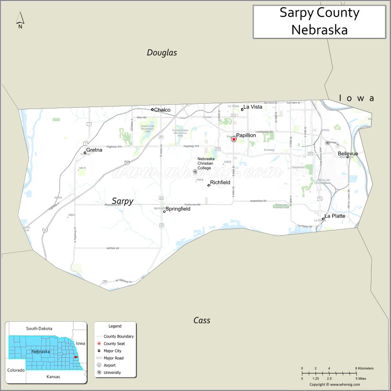
About Sarpy County Map, Nebraska: The map showing the county boundary, county seat, major cities, highways, water bodies and neighbouring counties.
Related Nebraska Maps & Info
Map of Sarpy County, Nebraska
Sarpy County is a county located in the U.S. state of Nebraska. It's county seat is Papillion. As per 2020 census, the population of Sarpy County is 193418 people and population density is square miles. According to the United States Census Bureau, the county has a total area of 241 sq mi (624 km2). Sarpy County was established on 1857.
Sarpy County Facts
| Continent | North America |
| Country | United States |
| State | Nebraska |
| County Seat | Papillion |
| Largest City/Town | Bellevue |
| Established | 1857 |
| Total Area | 248 sq mi (642 sq km) |
| Land Area | 239 sq mi (619 sq km) |
| Water Area | 9 sq mi (23 sq km) |
| Population | 190,604 (Census 2020) |
| Population Density | 797 people per sq mi |
| Time Zone | Central Time Zone |
| Major Highways | Interstate 80, U.S. Route 75, Nebraska Highway 370 |
| Major Rivers | Missouri River, Platte River |
| Neighboring Counties | Douglas County, Cass County, Saunders County, Washington County, Mills County (Iowa) |
| Famous For | Offutt Air Force Base, suburban Omaha communities, and rapid population growth |
| Top Attractions | Fontenelle Forest, Chalco Hills Recreation Area, and Strategic Air Command & Aerospace Museum nearby region |
| Official Website | Official Website |
About Sarpy County, Nebraska
Sarpy County is located in eastern Nebraska within the Omaha metropolitan area and was established in 1857. The county seat is Papillion, while Bellevue is the largest city in the county. The county is known for suburban growth, Offutt Air Force Base, outdoor recreation areas, and major economic and residential development in eastern Nebraska.
Cities and Towns in Sarpy County, Nebraska
| City/Town | Population (Census 2020) | Latitude & Longitude |
|---|---|---|
| Bellevue | 64,176 | 41.1544°N, 95.9146°W |
| Papillion (county seat) | 24,159 | 41.1547°N, 96.0422°W |
| La Vista | 16,746 | 41.1839°N, 96.0311°W |
| Gretna | 5,083 | 41.1406°N, 96.2453°W |
| Springfield | 1,529 | 41.0831°N, 96.1342°W |
Golf Courses in Sarpy County, Nebraska
| Golf Course | Location | Latitude & Longitude |
|---|---|---|
| Tara Hills Golf Course | Papillion | 41.1585°N, 96.0489°W |
| Willow Lakes Golf Course | Bellevue | 41.1609°N, 95.9204°W |
| Quarry Oaks Golf Club | Ashland nearby region | 41.0331°N, 96.3358°W |
Roads and Highways in Sarpy County, Nebraska
Major highways connect the county to Omaha and nearby regional destinations.
- Interstate 80 - major east-west interstate route through eastern Nebraska
- U.S. Route 75 - highway linking Bellevue with Omaha and southeastern Nebraska
- Nebraska Highway 370 - important suburban corridor connecting Papillion, Gretna, and Bellevue
Neighboring Counties of Sarpy County
- Douglas County (north)
- Washington County (northwest)
- Saunders County (west)
- Cass County (south)
- Mills County, Iowa (east)
What Are the Top Attractions in Sarpy County, Nebraska
The county offers a mix of urban, cultural, historical, and outdoor attractions.
- Fontenelle Forest - large nature preserve featuring hiking trails, wetlands, and wildlife habitats
- Chalco Hills Recreation Area - popular destination for walking, biking, fishing, and outdoor recreation
- Strategic Air Command & Aerospace Museum Nearby Region - aviation and military history museum with aircraft exhibits
- Offutt Air Force Base - major U.S. Air Force installation and headquarters of U.S. Strategic Command
- Papillion Downtown District - local shops, restaurants, entertainment, and community events
- Werner Park - baseball stadium home to the Omaha Storm Chasers minor league team
- La Vista Community Recreation Areas - parks, sports complexes, and family-friendly spaces
- Missouri River Scenic Areas - natural landscapes ideal for wildlife viewing and photography
- Sarpy County Fairgrounds - venue for fairs, concerts, festivals, and community events
- Outdoor Recreation Trails - biking, hiking, birdwatching, and fitness opportunities across the county
What Is the Distance from Sarpy County to Nearby Cities
The following distances are measured by road (driving).
- Papillion to Omaha (Douglas County), Nebraska - 10 mi (16 km)
- Papillion to Lincoln (Lancaster County), Nebraska - 55 mi (89 km)
- Papillion to Fremont (Dodge County), Nebraska - 43 mi (69 km)
- Papillion to Nebraska City (Otoe County), Nebraska - 48 mi (77 km)
- Papillion to Council Bluffs, Iowa - 15 mi (24 km)
- Papillion to Sioux City, Iowa - 102 mi (164 km)
- Papillion to Des Moines, Iowa - 137 mi (220 km)
- Papillion to Kansas City, Missouri - 186 mi (299 km)
- Papillion to Grand Island (Hall County), Nebraska - 149 mi (240 km)
- Papillion to Kearney (Buffalo County), Nebraska - 186 mi (299 km)
- Papillion to North Platte (Lincoln County), Nebraska - 281 mi (452 km)
- Papillion to Denver, Colorado - 538 mi (866 km)
FAQs about Sarpy County
Sarpy County is located in eastern Nebraska within the Omaha metropolitan area.
Sarpy County had a population of 190,604 according to Census 2020 data.
Sarpy County is known for Offutt Air Force Base, suburban Omaha communities, and rapid growth.
The county is served by Interstate 80, U.S. Route 75, and Nebraska Highway 370.
Yes, Sarpy County has golf facilities including Tara Hills Golf Course and Willow Lakes Golf Course.
References
- QuickFacts - U.S. Census Bureau
- United States Census Bureau
- United States Geological Survey (USGS)
- National Geodetic Survey
- Official County Website
- Adams County Map
- Antelope County Map
- Arthur County Map
- Banner County Map
- Blaine County Map
- Boone County Map
- Box Butte County Map
- Boyd County Map
- Brown County Map
- Buffalo County Map
- Burt County Map
- Butler County Map
- Cass County Map
- Cedar County Map
- Chase County Map
- Cherry County Map
- Cheyenne County Map
- Clay County Map
- Colfax County Map
- Cuming County Map
- Custer County Map
- Dakota County Map
- Dawes County Map
- Dawson County Map
- Deuel County Map
- Dixon County Map
- Dodge County Map
- Douglas County Map
- Dundy County Map
- Fillmore County Map
- Franklin County Map
- Frontier County Map
- Furnas County Map
- Gage County Map
- Garden County Map
- Garfield County Map
- Gosper County Map
- Grant County Map
- Greeley County Map
- Hall County Map
- Hamilton County Map
- Harlan County Map
- Hayes County Map
- Hitchcock County Map
- Holt County Map
- Hooker County Map
- Howard County Map
- Jefferson County Map
- Johnson County Map
- Kearney County Map
- Keith County Map
- Keya Paha County Map
- Kimball County Map
- Knox County Map
- Lancaster County Map
- Lincoln County Map
- Logan County Map
- Loup County Map
- McPherson County Map
- Madison County Map
- Merrick County Map
- Morrill County Map
- Nance County Map
- Nemaha County Map
- Nuckolls County Map
- Otoe County Map
- Pawnee County Map
- Perkins County Map
- Phelps County Map
- Pierce County Map
- Platte County Map
- Polk County Map
- Red Willow County Map
- Richardson County Map
- Rock County Map
- Saline County Map
- Sarpy County Map
- Saunders County Map
- Scotts Bluff County Map
- Seward County Map
- Sheridan County Map
- Sherman County Map
- Sioux County Map
- Stanton County Map
- Thayer County Map
- Thomas County Map
- Thurston County Map
- Valley County Map
- Washington County Map
- Wayne County Map
- Webster County Map
- Wheeler County Map
- York County Map
- Alabama Counties
- Alaska boroughs
- Arizona Counties
- Arkansas Counties
- California County Map
- Colorado Counties
- Connecticut Counties
- Delaware Counties
- Florida County Map
- Georgia County Map
- Hawaii Counties
- Idaho Counties
- Illinois Counties
- Indiana Counties
- Iowa Counties
- Kansas Counties
- Kentucky Counties
- Louisiana Counties
- Maine Counties
- Maryland Counties
- Massachusetts Counties
- Michigan County Map
- Minnesota Counties
- Mississippi Counties
- Missouri Counties
- Montana Counties
- Nebraska Counties
- Nevada Counties
- New York Counties
- New Hampshire Counties
- New Jersey Counties
- New Mexico Counties
- North Carolina Counties
- North Dakota Counties
- Ohio County Map
- Oklahoma Counties
- Oregon Counties
- Pennsylvania Counties
- Rhode Island Counties
- South Carolina Counties
- South Dakota Counties
- Map of Tennessee
- Texas County Map
- Utah Counties
- Vermont Counties
- Virginia Counties
- Washington Counties
- West Virginia Counties
- Wisconsin Counties
- Wyoming Counties