Written and Fact-checked by Whereig Editors, Reviewed by Mukesh Kumar| Last Updated On: May 10, 2026
Map of Deuel County - Deuel County is a county located in the U.S. state of Nebraska. Deuel County Map showing cities, highways, important places and water bodies. Get Where is Deuel County located in the map, major cities in Deuel county, population, areas, and places of interest.
Map of Deuel County, Nebraska
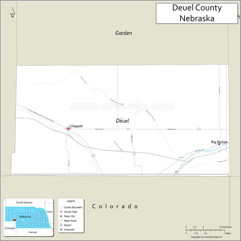
About Deuel County Map, Nebraska: The map showing the county boundary, county seat, major cities, highways, water bodies and neighbouring counties.
Related Nebraska Maps & Info
Map of Deuel County, Nebraska
Deuel County is a county located in the U.S. state of Nebraska. It's county seat is Chappell. As per 2020 census, the population of Deuel County is 1865 people and population density is square miles. According to the United States Census Bureau, the county has a total area of 440 sq mi (1,140 km2). Deuel County was established on 1888.
Deuel County Facts
| Continent | North America |
| Country | United States |
| State | Nebraska |
| County Seat | Chappell |
| Largest City/Town | Chappell |
| Established | 1889 |
| Total Area | 440 sq mi (1,140 sq km) |
| Land Area | 440 sq mi (1,140 sq km) |
| Water Area | 0.4 sq mi (1 sq km) |
| Population | 1,891 (Census 2020) |
| Population Density | 4.3 people per sq mi |
| Time Zone | Mountain Time Zone (MT) |
| Major Highways | Interstate 80, US 30, NE 17 |
| Major Rivers | South Platte River |
| Neighboring Counties | Keith County, Garden County, Cheyenne County, Perkins County, Sedgwick County (CO) |
| Famous For | South Platte River Valley, agriculture, Oregon Trail history, prairie recreation |
| Top Attractions | Windlass Hill, Chappell Museum, South Platte River recreation, Oregon Trail landmarks |
| Official Website | Official Website |
About Deuel County, Nebraska
Deuel County is located in western Nebraska in the United States and was established in 1889. The county seat and largest city is Chappell. The county is known for Oregon Trail history, South Platte River Valley scenery, agriculture, and peaceful High Plains landscapes.
Cities and Towns in Deuel County, Nebraska
| City/Town | Population (Census 2020) | Latitude & Longitude |
|---|---|---|
| Chappell (county seat) | 929 | 41.0936°N, 102.4705°W |
| Big Springs | 400 | 41.0631°N, 102.0743°W |
| Oshkosh nearby | 814 | 41.4017°N, 102.3444°W |
| Brule nearby | 326 | 41.0908°N, 101.8946°W |
| Roscoe nearby | 63 | 41.1283°N, 101.5669°W |
| Lorenzo community | Small rural community | 41.1300°N, 102.8189°W |
Golf Courses in Deuel County, Nebraska
| Golf Course | Location | Latitude & Longitude |
|---|---|---|
| Chappell Golf Club | Chappell | 41.0995°N, 102.4787°W |
| Bayside Golf Club nearby | Ogallala | 41.1708°N, 101.7187°W |
| Crandall Creek Golf Club nearby | Ogallala | 41.1297°N, 101.7198°W |
| Hillside Golf Course nearby | Sidney | 41.1486°N, 102.9871°W |
Roads and Highways in Deuel County, Nebraska
Major highways connect the county to western Nebraska communities and Interstate transportation routes.
- Interstate 80 - major east-west interstate highway across Nebraska
- US Highway 30 - historic Lincoln Highway and Oregon Trail route
- Nebraska Highway 17 - regional roadway serving local communities
Neighboring Counties of Deuel County
- Keith County (east)
- Garden County (north)
- Cheyenne County (west)
- Perkins County (south)
- Sedgwick County, Colorado (southwest)
What Are the Top Attractions in Deuel County, Nebraska
The county offers a mix of Oregon Trail history, prairie scenery, and outdoor recreation.
- Windlass Hill - historic Oregon Trail landmark with scenic prairie views
- Chappell Museum - exhibits on local history, pioneer life, and regional heritage
- South Platte River recreation - fishing, wildlife viewing, and scenic outdoor activities
- Historic Oregon Trail sites - pioneer migration landmarks and educational attractions
- Chappell Golf Club - golf and recreation destination
- Prairie scenic drives - High Plains landscapes and countryside views
- Birdwatching and wildlife habitats - river ecosystems and migratory birds
- Fishing and hunting opportunities - pheasant, deer, turkey, and upland game recreation
- Camping and RV parks nearby - family-friendly outdoor recreation destinations
- Photography and sunset viewing across western Nebraska prairies - scenic outdoor experiences
- Historic railroad heritage attractions - showcasing western transportation history
- Regional fairs and rodeos - celebrating agriculture and ranching traditions
- Nearby Lake McConaughy attractions - boating, fishing, beaches, and water recreation
- Dark sky stargazing - clear High Plains night skies with minimal light pollution
What Is the Distance from Deuel County to Nearby Cities
The following distances are measured by road (driving).
- Chappell to Ogallala (Keith County), Nebraska - 39 mi (63 km)
- Chappell to Sidney (Cheyenne County), Nebraska - 39 mi (63 km)
- Chappell to Scottsbluff (Scotts Bluff County), Nebraska - 92 mi (148 km)
- Chappell to North Platte (Lincoln County), Nebraska - 114 mi (183 km)
- Chappell to Sterling (Logan County), Colorado - 97 mi (156 km)
- Chappell to Denver (Denver County), Colorado - 187 mi (301 km)
- Chappell to Rapid City (Pennington County), South Dakota - 272 mi (438 km)
- Chappell to Lincoln (Lancaster County), Nebraska - 360 mi (579 km)
- Chappell to Omaha (Douglas County), Nebraska - 416 mi (669 km)
- Chappell to Pierre (Hughes County), South Dakota - 404 mi (650 km)
- Chappell to Sioux Falls (Minnehaha County), South Dakota - 518 mi (834 km)
- Chappell to Kansas City (Jackson County), Missouri - 537 mi (864 km)
FAQs about Deuel County
Deuel County is located in western Nebraska near the Colorado border.
Deuel County had a population of 1,891 according to the 2020 United States Census.
Deuel County is known for Oregon Trail history, South Platte River Valley scenery, prairie recreation, and agriculture.
The major highways include Interstate 80, US Highway 30, and Nebraska Highway 17.
Popular attractions include Windlass Hill, Chappell Museum, South Platte River recreation areas, and nearby Lake McConaughy attractions.
References
- QuickFacts - U.S. Census Bureau
- United States Census Bureau
- United States Geological Survey (USGS)
- National Geodetic Survey
- Official Website
- Adams County Map
- Antelope County Map
- Arthur County Map
- Banner County Map
- Blaine County Map
- Boone County Map
- Box Butte County Map
- Boyd County Map
- Brown County Map
- Buffalo County Map
- Burt County Map
- Butler County Map
- Cass County Map
- Cedar County Map
- Chase County Map
- Cherry County Map
- Cheyenne County Map
- Clay County Map
- Colfax County Map
- Cuming County Map
- Custer County Map
- Dakota County Map
- Dawes County Map
- Dawson County Map
- Deuel County Map
- Dixon County Map
- Dodge County Map
- Douglas County Map
- Dundy County Map
- Fillmore County Map
- Franklin County Map
- Frontier County Map
- Furnas County Map
- Gage County Map
- Garden County Map
- Garfield County Map
- Gosper County Map
- Grant County Map
- Greeley County Map
- Hall County Map
- Hamilton County Map
- Harlan County Map
- Hayes County Map
- Hitchcock County Map
- Holt County Map
- Hooker County Map
- Howard County Map
- Jefferson County Map
- Johnson County Map
- Kearney County Map
- Keith County Map
- Keya Paha County Map
- Kimball County Map
- Knox County Map
- Lancaster County Map
- Lincoln County Map
- Logan County Map
- Loup County Map
- McPherson County Map
- Madison County Map
- Merrick County Map
- Morrill County Map
- Nance County Map
- Nemaha County Map
- Nuckolls County Map
- Otoe County Map
- Pawnee County Map
- Perkins County Map
- Phelps County Map
- Pierce County Map
- Platte County Map
- Polk County Map
- Red Willow County Map
- Richardson County Map
- Rock County Map
- Saline County Map
- Sarpy County Map
- Saunders County Map
- Scotts Bluff County Map
- Seward County Map
- Sheridan County Map
- Sherman County Map
- Sioux County Map
- Stanton County Map
- Thayer County Map
- Thomas County Map
- Thurston County Map
- Valley County Map
- Washington County Map
- Wayne County Map
- Webster County Map
- Wheeler County Map
- York County Map
- Alabama Counties
- Alaska boroughs
- Arizona Counties
- Arkansas Counties
- California County Map
- Colorado Counties
- Connecticut Counties
- Delaware Counties
- Florida County Map
- Georgia County Map
- Hawaii Counties
- Idaho Counties
- Illinois Counties
- Indiana Counties
- Iowa Counties
- Kansas Counties
- Kentucky Counties
- Louisiana Counties
- Maine Counties
- Maryland Counties
- Massachusetts Counties
- Michigan County Map
- Minnesota Counties
- Mississippi Counties
- Missouri Counties
- Montana Counties
- Nebraska Counties
- Nevada Counties
- New York Counties
- New Hampshire Counties
- New Jersey Counties
- New Mexico Counties
- North Carolina Counties
- North Dakota Counties
- Ohio County Map
- Oklahoma Counties
- Oregon Counties
- Pennsylvania Counties
- Rhode Island Counties
- South Carolina Counties
- South Dakota Counties
- Map of Tennessee
- Texas County Map
- Utah Counties
- Vermont Counties
- Virginia Counties
- Washington Counties
- West Virginia Counties
- Wisconsin Counties
- Wyoming Counties