Written and Fact-checked by Whereig Editors, Reviewed by Mukesh Kumar| Last Updated On: May 10, 2026
Map of Otoe County - Otoe County is a county located in the U.S. state of Nebraska. Otoe County Map showing cities, highways, important places and water bodies. Get Where is Otoe County located in the map, major cities in Otoe county, population, areas, and places of interest.
Map of Otoe County, Nebraska
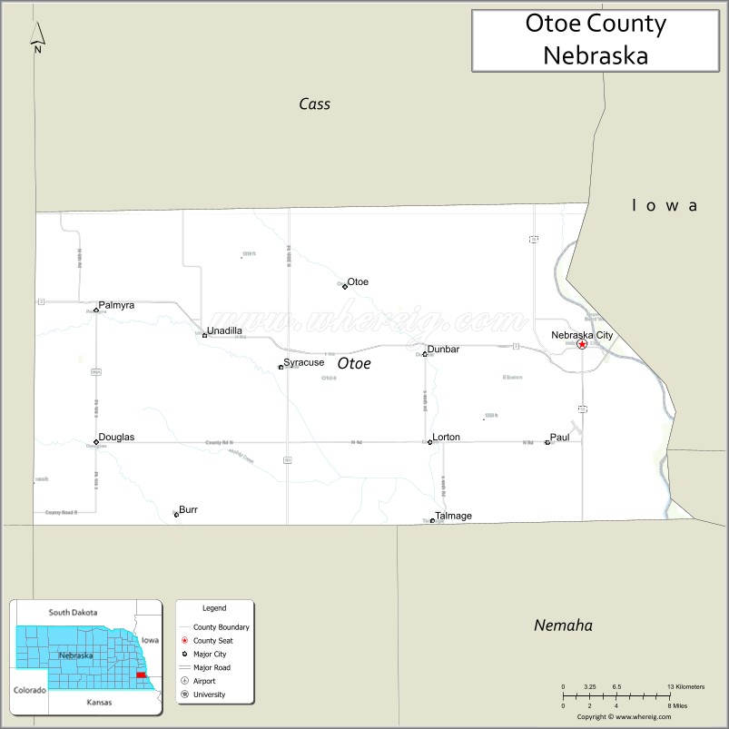
About Otoe County Map, Nebraska: The map showing the county boundary, county seat, major cities, highways, water bodies and neighbouring counties.
Related Nebraska Maps & Info
Map of Otoe County, Nebraska
Otoe County is a county located in the U.S. state of Nebraska. It's county seat is Nebraska City. As per 2020 census, the population of Otoe County is 15930 people and population density is square miles. According to the United States Census Bureau, the county has a total area of 616 sq mi (1,595 km2). Otoe County was established on 1854.
Otoe County Facts
| Continent | North America |
| Country | United States |
| State | Nebraska |
| County Seat | Nebraska City |
| Largest City/Town | Nebraska City |
| Established | 1854 |
| Total Area | 619 sq mi (1,603 sq km) |
| Land Area | 615 sq mi (1,593 sq km) |
| Water Area | 4 sq mi (10 sq km) |
| Population | 15,912 (Census 2020) |
| Population Density | 25.9 people per sq mi |
| Time Zone | Central Time Zone |
| Major Highways | U.S. Route 75, U.S. Route 34, Nebraska Highway 2 |
| Major Rivers | Missouri River, Platte River |
| Neighboring Counties | Cass County, Lancaster County, Johnson County, Nemaha County, Fremont County (Iowa) |
| Famous For | Arbor Day origins, Nebraska City, and Missouri River history |
| Top Attractions | Arbor Day Farm, Arbor Lodge State Historical Park, and Lewis and Clark Visitor Center |
| Official Website | Official Website |
About Otoe County, Nebraska
Otoe County is located in southeastern Nebraska along the Missouri River and was established in 1854. The county seat is Nebraska City, which is also the largest city in the county. The county is known for its historic connection to Arbor Day, scenic river landscapes, orchards, agriculture, and pioneer-era heritage.
Cities and Towns in Otoe County, Nebraska
| City/Town | Population (Census 2020) | Latitude & Longitude |
|---|---|---|
| Nebraska City (county seat) | 7,222 | 40.6767°N, 95.8592°W |
| Burr | 60 | 40.5367°N, 95.9920°W |
| Douglas | 171 | 40.6025°N, 96.3786°W |
| Dunbar | 88 | 40.6639°N, 96.0281°W |
| Lorton | 41 | 40.6028°N, 96.0944°W |
| Palmyra | 545 | 40.7070°N, 96.3875°W |
| Syracuse | 1,942 | 40.6581°N, 96.1867°W |
| Talmage | 233 | 40.5303°N, 96.0247°W |
| Unadilla | 311 | 40.6858°N, 96.2844°W |
Golf Courses in Otoe County, Nebraska
| Golf Course | Location | Latitude & Longitude |
|---|---|---|
| ArborLinks Golf Club | Nebraska City | 40.6824°N, 95.8648°W |
| Nebraska City Country Club | Nebraska City | 40.6789°N, 95.8707°W |
| Syracuse Country Club | Syracuse | 40.6605°N, 96.1919°W |
Roads and Highways in Otoe County, Nebraska
Major highways connect the county to nearby regions and communities.
- U.S. Route 75 - north-south highway linking Nebraska City with Omaha and Kansas regions
- U.S. Route 34 - east-west route serving southeastern Nebraska and Iowa connections
- Nebraska Highway 2 - regional route connecting Lincoln with Nebraska City and river communities
Neighboring Counties of Otoe County
- Cass County (north)
- Lancaster County (west)
- Johnson County (southwest)
- Nemaha County (south)
- Fremont County, Iowa (east)
What Are the Top Attractions in Otoe County, Nebraska
The county offers a mix of historical, cultural, and outdoor attractions.
- Arbor Day Farm - educational nature attraction featuring orchards, trails, and tree-themed exhibits
- Arbor Lodge State Historical Park - historic mansion and estate of Arbor Day founder J. Sterling Morton
- Lewis and Clark Visitor Center - interpretive center highlighting regional exploration history
- Nebraska City Historic District - downtown area with shops, restaurants, and historic architecture
- Kimmel Orchard and Vineyard - popular destination featuring orchards, seasonal events, and local produce
- Missouri River Scenic Areas - natural landscapes ideal for birdwatching and photography
- Syracuse Community Parks - recreation areas with sports facilities and picnic grounds
- Palmyra Prairie Landscapes - scenic countryside featuring rolling farmland and open views
- Otoe County Fairgrounds - venue for county fairs, festivals, and livestock events
- Steamboat Trace Trail Nearby Access - regional biking and hiking trail along historic transportation routes
What Is the Distance from Otoe County to Nearby Cities
The following distances are measured by road (driving).
- Nebraska City to Lincoln (Lancaster County), Nebraska - 49 mi (79 km)
- Nebraska City to Omaha (Douglas County), Nebraska - 50 mi (80 km)
- Nebraska City to Beatrice (Gage County), Nebraska - 56 mi (90 km)
- Nebraska City to Auburn (Nemaha County), Nebraska - 33 mi (53 km)
- Nebraska City to Council Bluffs, Iowa - 53 mi (85 km)
- Nebraska City to Kansas City, Missouri - 177 mi (285 km)
- Nebraska City to Grand Island (Hall County), Nebraska - 141 mi (227 km)
- Nebraska City to Kearney (Buffalo County), Nebraska - 179 mi (288 km)
- Nebraska City to North Platte (Lincoln County), Nebraska - 282 mi (454 km)
- Nebraska City to Sioux City, Iowa - 145 mi (233 km)
- Nebraska City to Des Moines, Iowa - 167 mi (269 km)
- Nebraska City to Denver, Colorado - 536 mi (863 km)
FAQs about Otoe County
Otoe County is located in southeastern Nebraska along the Missouri River.
Otoe County had a population of 15,912 according to Census 2020 data.
Otoe County is known for Arbor Day history, Nebraska City, orchards, and Missouri River heritage.
The county is served by U.S. Route 75, U.S. Route 34, and Nebraska Highway 2.
Yes, Otoe County has golf facilities including ArborLinks Golf Club and Nebraska City Country Club.
References
- QuickFacts - U.S. Census Bureau
- United States Census Bureau
- United States Geological Survey (USGS)
- National Geodetic Survey
- Official County Website
- Adams County Map
- Antelope County Map
- Arthur County Map
- Banner County Map
- Blaine County Map
- Boone County Map
- Box Butte County Map
- Boyd County Map
- Brown County Map
- Buffalo County Map
- Burt County Map
- Butler County Map
- Cass County Map
- Cedar County Map
- Chase County Map
- Cherry County Map
- Cheyenne County Map
- Clay County Map
- Colfax County Map
- Cuming County Map
- Custer County Map
- Dakota County Map
- Dawes County Map
- Dawson County Map
- Deuel County Map
- Dixon County Map
- Dodge County Map
- Douglas County Map
- Dundy County Map
- Fillmore County Map
- Franklin County Map
- Frontier County Map
- Furnas County Map
- Gage County Map
- Garden County Map
- Garfield County Map
- Gosper County Map
- Grant County Map
- Greeley County Map
- Hall County Map
- Hamilton County Map
- Harlan County Map
- Hayes County Map
- Hitchcock County Map
- Holt County Map
- Hooker County Map
- Howard County Map
- Jefferson County Map
- Johnson County Map
- Kearney County Map
- Keith County Map
- Keya Paha County Map
- Kimball County Map
- Knox County Map
- Lancaster County Map
- Lincoln County Map
- Logan County Map
- Loup County Map
- McPherson County Map
- Madison County Map
- Merrick County Map
- Morrill County Map
- Nance County Map
- Nemaha County Map
- Nuckolls County Map
- Otoe County Map
- Pawnee County Map
- Perkins County Map
- Phelps County Map
- Pierce County Map
- Platte County Map
- Polk County Map
- Red Willow County Map
- Richardson County Map
- Rock County Map
- Saline County Map
- Sarpy County Map
- Saunders County Map
- Scotts Bluff County Map
- Seward County Map
- Sheridan County Map
- Sherman County Map
- Sioux County Map
- Stanton County Map
- Thayer County Map
- Thomas County Map
- Thurston County Map
- Valley County Map
- Washington County Map
- Wayne County Map
- Webster County Map
- Wheeler County Map
- York County Map
- Alabama Counties
- Alaska boroughs
- Arizona Counties
- Arkansas Counties
- California County Map
- Colorado Counties
- Connecticut Counties
- Delaware Counties
- Florida County Map
- Georgia County Map
- Hawaii Counties
- Idaho Counties
- Illinois Counties
- Indiana Counties
- Iowa Counties
- Kansas Counties
- Kentucky Counties
- Louisiana Counties
- Maine Counties
- Maryland Counties
- Massachusetts Counties
- Michigan County Map
- Minnesota Counties
- Mississippi Counties
- Missouri Counties
- Montana Counties
- Nebraska Counties
- Nevada Counties
- New York Counties
- New Hampshire Counties
- New Jersey Counties
- New Mexico Counties
- North Carolina Counties
- North Dakota Counties
- Ohio County Map
- Oklahoma Counties
- Oregon Counties
- Pennsylvania Counties
- Rhode Island Counties
- South Carolina Counties
- South Dakota Counties
- Map of Tennessee
- Texas County Map
- Utah Counties
- Vermont Counties
- Virginia Counties
- Washington Counties
- West Virginia Counties
- Wisconsin Counties
- Wyoming Counties