Written and Fact-checked by Whereig Editors, Reviewed by Mukesh Kumar| Last Updated On: May 10, 2026
Map of Garden County - Garden County is a county located in the U.S. state of Nebraska. Garden County Map showing cities, highways, important places and water bodies. Get Where is Garden County located in the map, major cities in Garden county, population, areas, and places of interest.
Map of Garden County, Nebraska
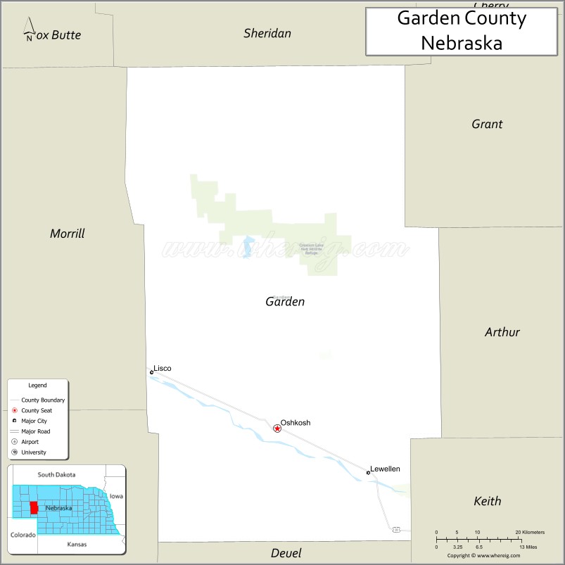
About Garden County Map, Nebraska: The map showing the county boundary, county seat, major cities, highways, water bodies and neighbouring counties.
Related Nebraska Maps & Info
Map of Garden County, Nebraska
Garden County is a county located in the U.S. state of Nebraska. It's county seat is Oshkosh. As per 2020 census, the population of Garden County is 1847 people and population density is square miles. According to the United States Census Bureau, the county has a total area of 1,705 sq mi (4,416 km2). Garden County was established on 1910.
Garden County Facts
| Continent | North America |
| Country | United States |
| State | Nebraska |
| County Seat | Oshkosh |
| Largest City/Town | Oshkosh |
| Established | 1909 |
| Total Area | 1,731 sq mi (4,483 sq km) |
| Land Area | 1,705 sq mi (4,416 sq km) |
| Water Area | 26 sq mi (67 sq km) |
| Population | 1,893 (Census 2020) |
| Population Density | 1.1 people per sq mi |
| Time Zone | Mountain Time Zone (MT) |
| Major Highways | US 26, NE 27, NE 92 |
| Major Rivers | North Platte River |
| Neighboring Counties | Sheridan County, Grant County, Keith County, Morrill County, Deuel County |
| Famous For | Lake McConaughy, Sandhills scenery, outdoor recreation, Nebraska prairie landscapes |
| Top Attractions | Lake McConaughy, Crescent Lake National Wildlife Refuge nearby, Oshkosh attractions, North Platte River recreation |
| Official Website | Official Website |
About Garden County, Nebraska
Garden County is located in western Nebraska in the United States and was established in 1909. The county seat and largest city is Oshkosh. The county is known for Lake McConaughy, Sandhills landscapes, prairie recreation, and scenic outdoor experiences along the North Platte River Valley.
Cities and Towns in Garden County, Nebraska
| City/Town | Population (Census 2020) | Latitude & Longitude |
|---|---|---|
| Oshkosh (county seat) | 814 | 41.4017°N, 102.3444°W |
| Lewellen | 224 | 41.3231°N, 102.1437°W |
| Lisco | 68 | 41.4981°N, 102.6219°W |
| Blue Creek community | Small rural community | 41.3881°N, 102.5278°W |
| Martin Bay area | Recreation community | 41.2183°N, 101.8925°W |
| Lake McConaughy area | Outdoor recreation region | 41.2106°N, 101.7266°W |
Golf Courses in Garden County, Nebraska
| Golf Course | Location | Latitude & Longitude |
|---|---|---|
| Oshkosh Country Club | Oshkosh | 41.4098°N, 102.3526°W |
| Bayside Golf Club nearby | Ogallala | 41.1708°N, 101.7187°W |
| Crandall Creek Golf Club nearby | Ogallala | 41.1297°N, 101.7198°W |
| Ash Hollow Golf Course nearby | Lewellen | 41.3125°N, 102.1381°W |
Roads and Highways in Garden County, Nebraska
Major highways connect the county to western Nebraska communities and outdoor recreation destinations.
- US Highway 26 - major transportation corridor along the North Platte River Valley
- Nebraska Highway 27 - regional roadway through Sandhills communities
- Nebraska Highway 92 - scenic route near Lake McConaughy and western Nebraska recreation areas
Neighboring Counties of Garden County
- Sheridan County (north)
- Grant County (east)
- Keith County (southeast)
- Deuel County (south)
- Morrill County (west)
What Are the Top Attractions in Garden County, Nebraska
The county offers exceptional outdoor recreation, Sandhills scenery, and lakeside experiences.
- Lake McConaughy - Nebraska’s largest reservoir with boating, fishing, beaches, and camping
- Crescent Lake National Wildlife Refuge nearby - wildlife viewing, birdwatching, and prairie scenery
- North Platte River recreation - kayaking, fishing, and scenic outdoor activities
- Oshkosh attractions - local restaurants, parks, and community events
- Oshkosh Country Club - golf and recreation destination
- Sandhills scenic drives - rolling dunes, prairie grasslands, and panoramic landscapes
- Fishing and hunting opportunities - walleye, catfish, deer, turkey, and waterfowl recreation
- Birdwatching and wildlife habitats - migratory birds and Sandhills ecosystems
- Camping and RV parks throughout the county - family-friendly outdoor recreation destinations
- Photography and sunset viewing over Lake McConaughy and prairie landscapes - scenic Nebraska experiences
- Historic western Nebraska trails and pioneer heritage attractions - regional settlement history
- Water sports and beach recreation - swimming, sailing, paddleboarding, and jet skiing opportunities
- Dark sky stargazing - clear western Nebraska night skies with low light pollution
- Nature exploration and peaceful prairie landscapes - quiet outdoor recreation experiences
What Is the Distance from Garden County to Nearby Cities
The following distances are measured by road (driving).
- Oshkosh to Ogallala (Keith County), Nebraska - 39 mi (63 km)
- Oshkosh to Scottsbluff (Scotts Bluff County), Nebraska - 74 mi (119 km)
- Oshkosh to Sidney (Cheyenne County), Nebraska - 85 mi (137 km)
- Oshkosh to North Platte (Lincoln County), Nebraska - 112 mi (180 km)
- Oshkosh to Rapid City (Pennington County), South Dakota - 244 mi (393 km)
- Oshkosh to Denver (Denver County), Colorado - 230 mi (370 km)
- Oshkosh to Grand Island (Hall County), Nebraska - 221 mi (356 km)
- Oshkosh to Lincoln (Lancaster County), Nebraska - 369 mi (594 km)
- Oshkosh to Omaha (Douglas County), Nebraska - 425 mi (684 km)
- Oshkosh to Pierre (Hughes County), South Dakota - 378 mi (608 km)
- Oshkosh to Sioux Falls (Minnehaha County), South Dakota - 517 mi (832 km)
- Oshkosh to Kansas City (Jackson County), Missouri - 546 mi (879 km)
FAQs about Garden County
Garden County is located in western Nebraska in the Sandhills region.
Garden County had a population of 1,893 according to the 2020 United States Census.
Garden County is known for Lake McConaughy, Sandhills scenery, prairie recreation, and North Platte River outdoor activities.
The major highways include US Highway 26, Nebraska Highway 27, and Nebraska Highway 92.
Popular attractions include Lake McConaughy, North Platte River recreation, Sandhills scenic drives, and Crescent Lake National Wildlife Refuge nearby.
References
- QuickFacts - U.S. Census Bureau
- United States Census Bureau
- United States Geological Survey (USGS)
- National Geodetic Survey
- Official Website
- Adams County Map
- Antelope County Map
- Arthur County Map
- Banner County Map
- Blaine County Map
- Boone County Map
- Box Butte County Map
- Boyd County Map
- Brown County Map
- Buffalo County Map
- Burt County Map
- Butler County Map
- Cass County Map
- Cedar County Map
- Chase County Map
- Cherry County Map
- Cheyenne County Map
- Clay County Map
- Colfax County Map
- Cuming County Map
- Custer County Map
- Dakota County Map
- Dawes County Map
- Dawson County Map
- Deuel County Map
- Dixon County Map
- Dodge County Map
- Douglas County Map
- Dundy County Map
- Fillmore County Map
- Franklin County Map
- Frontier County Map
- Furnas County Map
- Gage County Map
- Garden County Map
- Garfield County Map
- Gosper County Map
- Grant County Map
- Greeley County Map
- Hall County Map
- Hamilton County Map
- Harlan County Map
- Hayes County Map
- Hitchcock County Map
- Holt County Map
- Hooker County Map
- Howard County Map
- Jefferson County Map
- Johnson County Map
- Kearney County Map
- Keith County Map
- Keya Paha County Map
- Kimball County Map
- Knox County Map
- Lancaster County Map
- Lincoln County Map
- Logan County Map
- Loup County Map
- McPherson County Map
- Madison County Map
- Merrick County Map
- Morrill County Map
- Nance County Map
- Nemaha County Map
- Nuckolls County Map
- Otoe County Map
- Pawnee County Map
- Perkins County Map
- Phelps County Map
- Pierce County Map
- Platte County Map
- Polk County Map
- Red Willow County Map
- Richardson County Map
- Rock County Map
- Saline County Map
- Sarpy County Map
- Saunders County Map
- Scotts Bluff County Map
- Seward County Map
- Sheridan County Map
- Sherman County Map
- Sioux County Map
- Stanton County Map
- Thayer County Map
- Thomas County Map
- Thurston County Map
- Valley County Map
- Washington County Map
- Wayne County Map
- Webster County Map
- Wheeler County Map
- York County Map
- Alabama Counties
- Alaska boroughs
- Arizona Counties
- Arkansas Counties
- California County Map
- Colorado Counties
- Connecticut Counties
- Delaware Counties
- Florida County Map
- Georgia County Map
- Hawaii Counties
- Idaho Counties
- Illinois Counties
- Indiana Counties
- Iowa Counties
- Kansas Counties
- Kentucky Counties
- Louisiana Counties
- Maine Counties
- Maryland Counties
- Massachusetts Counties
- Michigan County Map
- Minnesota Counties
- Mississippi Counties
- Missouri Counties
- Montana Counties
- Nebraska Counties
- Nevada Counties
- New York Counties
- New Hampshire Counties
- New Jersey Counties
- New Mexico Counties
- North Carolina Counties
- North Dakota Counties
- Ohio County Map
- Oklahoma Counties
- Oregon Counties
- Pennsylvania Counties
- Rhode Island Counties
- South Carolina Counties
- South Dakota Counties
- Map of Tennessee
- Texas County Map
- Utah Counties
- Vermont Counties
- Virginia Counties
- Washington Counties
- West Virginia Counties
- Wisconsin Counties
- Wyoming Counties