Written and Fact-checked by Whereig Editors, Reviewed by Mukesh Kumar| Last Updated On: May 10, 2026
Map of Knox County - Knox County is a county located in the U.S. state of Nebraska. Knox County Map showing cities, highways, important places and water bodies. Get Where is Knox County located in the map, major cities in Knox county, population, areas, and places of interest.
Map of Knox County, Nebraska
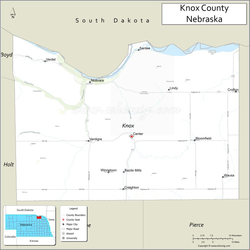
About Knox County Map, Nebraska: The map showing the county boundary, county seat, major cities, highways, water bodies and neighbouring counties.
Related Nebraska Maps & Info
Map of Knox County, Nebraska
Knox County is a county located in the U.S. state of Nebraska. It's county seat is Center. As per 2020 census, the population of Knox County is 8401 people and population density is square miles. According to the United States Census Bureau, the county has a total area of 1,108 sq mi (2,870 km2). Knox County was established on 1857.
Knox County Facts
| Continent | North America |
| Country | United States |
| State | Nebraska |
| County Seat | Center |
| Largest City/Town | Creighton |
| Established | 1854 |
| Total Area | 1,109 sq mi (2,872 sq km) |
| Land Area | 1,084 sq mi (2,808 sq km) |
| Water Area | 25 sq mi (65 sq km) |
| Population | 8,391 (Census 2020) |
| Population Density | 7.7 people per sq mi |
| Time Zone | Central Time Zone |
| Major Highways | U.S. Route 20, Nebraska Highway 12, Nebraska Highway 14 |
| Major Rivers | Missouri River, Niobrara River |
| Neighboring Counties | Boyd County, Cedar County, Holt County, Antelope County, Charles Mix County (South Dakota) |
| Famous For | Lewis and Clark history, Missouri River recreation, and agriculture |
| Top Attractions | Niobrara State Park, Lewis and Clark Lake access, and Verdigre Creek Valley |
| Official Website | Official Website |
About Knox County, Nebraska
Knox County is located in northeastern Nebraska along the South Dakota border and was established in 1854. The county seat is Center, while Creighton is the largest city in the county. The county is known for its scenic river valleys, agricultural communities, outdoor recreation opportunities, and historic connections to the Lewis and Clark Expedition.
Cities and Towns in Knox County, Nebraska
| City/Town | Population (Census 2020) | Latitude & Longitude |
|---|---|---|
| Center (county seat) | 73 | 42.6089°N, 97.8789°W |
| Creighton | 1,153 | 42.4700°N, 97.9064°W |
| Bloomfield | 934 | 42.5961°N, 97.6450°W |
| Niobrara | 363 | 42.7547°N, 98.0384°W |
| Verdigre | 575 | 42.5986°N, 98.0367°W |
| Crofton | 726 | 42.7342°N, 97.4961°W |
| Santee | 346 | 42.8506°N, 97.8423°W |
| Wausa | 541 | 42.4994°N, 97.5403°W |
Golf Courses in Knox County, Nebraska
| Golf Course | Location | Latitude & Longitude |
|---|---|---|
| Verdigre Creek Golf Course | Verdigre | 42.6007°N, 98.0414°W |
| Creighton Country Club | Creighton | 42.4681°N, 97.9118°W |
| Lakeview Golf Course | Crofton | 42.7322°N, 97.5012°W |
Roads and Highways in Knox County, Nebraska
Major highways connect the county to nearby regions and communities.
- U.S. Route 20 - major east-west highway connecting Knox County with O'Neill and South Sioux City
- Nebraska Highway 12 - scenic route following the Missouri River corridor across northern Nebraska
- Nebraska Highway 14 - north-south highway serving agricultural and rural communities
Neighboring Counties of Knox County
- Boyd County (west)
- Holt County (southwest)
- Antelope County (south)
- Cedar County (east)
- Charles Mix County, South Dakota (north)
What Are the Top Attractions in Knox County, Nebraska
The county offers a mix of natural and cultural attractions.
- Niobrara State Park - scenic park overlooking the Missouri and Niobrara rivers with hiking and camping
- Lewis and Clark Lake Access Areas - boating, fishing, and recreation along the Missouri River
- Verdigre Creek Valley - picturesque prairie valley known for wildlife viewing and photography
- Ashfall Fossil Beds Access Region - nearby fossil and geological attractions in northeastern Nebraska
- Bloomfield Historic Downtown - local shops, historic buildings, and restaurants
- Crofton Community Recreation Area - parks, sports fields, and picnic spaces
- Santee Sioux Reservation Cultural Areas - sites reflecting Native American heritage and history
- Wausa Prairie Landscapes - scenic countryside featuring rolling farmland and grasslands
- Niobrara River Scenic Overlooks - panoramic river valley viewpoints
- Knox County Fairgrounds - venue for fairs, rodeos, and community events
What Is the Distance from Knox County to Nearby Cities
The following distances are measured by road (driving).
- Center to Norfolk (Madison County), Nebraska - 68 mi (109 km)
- Center to O'Neill (Holt County), Nebraska - 74 mi (119 km)
- Center to Yankton, South Dakota - 34 mi (55 km)
- Center to Sioux City, Iowa - 95 mi (153 km)
- Center to Columbus (Platte County), Nebraska - 139 mi (224 km)
- Center to Grand Island (Hall County), Nebraska - 195 mi (314 km)
- Center to Kearney (Buffalo County), Nebraska - 214 mi (344 km)
- Center to Lincoln (Lancaster County), Nebraska - 211 mi (340 km)
- Center to Omaha (Douglas County), Nebraska - 174 mi (280 km)
- Center to Valentine (Cherry County), Nebraska - 150 mi (241 km)
- Center to Sioux Falls, South Dakota - 149 mi (240 km)
- Center to Denver, Colorado - 504 mi (811 km)
FAQs about Knox County
Knox County is located in northeastern Nebraska along the South Dakota border.
Knox County had a population of 8,391 according to Census 2020 data.
Knox County is known for river recreation, agriculture, and Lewis and Clark history.
The county is served by U.S. Route 20, Nebraska Highway 12, and Nebraska Highway 14.
Yes, Knox County has golf facilities including Verdigre Creek Golf Course and Creighton Country Club.
References
- QuickFacts - U.S. Census Bureau
- United States Census Bureau
- United States Geological Survey (USGS)
- National Geodetic Survey
- Official County Website
- Adams County Map
- Antelope County Map
- Arthur County Map
- Banner County Map
- Blaine County Map
- Boone County Map
- Box Butte County Map
- Boyd County Map
- Brown County Map
- Buffalo County Map
- Burt County Map
- Butler County Map
- Cass County Map
- Cedar County Map
- Chase County Map
- Cherry County Map
- Cheyenne County Map
- Clay County Map
- Colfax County Map
- Cuming County Map
- Custer County Map
- Dakota County Map
- Dawes County Map
- Dawson County Map
- Deuel County Map
- Dixon County Map
- Dodge County Map
- Douglas County Map
- Dundy County Map
- Fillmore County Map
- Franklin County Map
- Frontier County Map
- Furnas County Map
- Gage County Map
- Garden County Map
- Garfield County Map
- Gosper County Map
- Grant County Map
- Greeley County Map
- Hall County Map
- Hamilton County Map
- Harlan County Map
- Hayes County Map
- Hitchcock County Map
- Holt County Map
- Hooker County Map
- Howard County Map
- Jefferson County Map
- Johnson County Map
- Kearney County Map
- Keith County Map
- Keya Paha County Map
- Kimball County Map
- Knox County Map
- Lancaster County Map
- Lincoln County Map
- Logan County Map
- Loup County Map
- McPherson County Map
- Madison County Map
- Merrick County Map
- Morrill County Map
- Nance County Map
- Nemaha County Map
- Nuckolls County Map
- Otoe County Map
- Pawnee County Map
- Perkins County Map
- Phelps County Map
- Pierce County Map
- Platte County Map
- Polk County Map
- Red Willow County Map
- Richardson County Map
- Rock County Map
- Saline County Map
- Sarpy County Map
- Saunders County Map
- Scotts Bluff County Map
- Seward County Map
- Sheridan County Map
- Sherman County Map
- Sioux County Map
- Stanton County Map
- Thayer County Map
- Thomas County Map
- Thurston County Map
- Valley County Map
- Washington County Map
- Wayne County Map
- Webster County Map
- Wheeler County Map
- York County Map
- Alabama Counties
- Alaska boroughs
- Arizona Counties
- Arkansas Counties
- California County Map
- Colorado Counties
- Connecticut Counties
- Delaware Counties
- Florida County Map
- Georgia County Map
- Hawaii Counties
- Idaho Counties
- Illinois Counties
- Indiana Counties
- Iowa Counties
- Kansas Counties
- Kentucky Counties
- Louisiana Counties
- Maine Counties
- Maryland Counties
- Massachusetts Counties
- Michigan County Map
- Minnesota Counties
- Mississippi Counties
- Missouri Counties
- Montana Counties
- Nebraska Counties
- Nevada Counties
- New York Counties
- New Hampshire Counties
- New Jersey Counties
- New Mexico Counties
- North Carolina Counties
- North Dakota Counties
- Ohio County Map
- Oklahoma Counties
- Oregon Counties
- Pennsylvania Counties
- Rhode Island Counties
- South Carolina Counties
- South Dakota Counties
- Map of Tennessee
- Texas County Map
- Utah Counties
- Vermont Counties
- Virginia Counties
- Washington Counties
- West Virginia Counties
- Wisconsin Counties
- Wyoming Counties