Written and Fact-checked by Whereig Editors, Reviewed by Mukesh Kumar| Last Updated On: May 10, 2026
Map of Sioux County - Sioux County is a county located in the U.S. state of Nebraska. Sioux County Map showing cities, highways, important places and water bodies. Get Where is Sioux County located in the map, major cities in Sioux county, population, areas, and places of interest.
Map of Sioux County, Nebraska
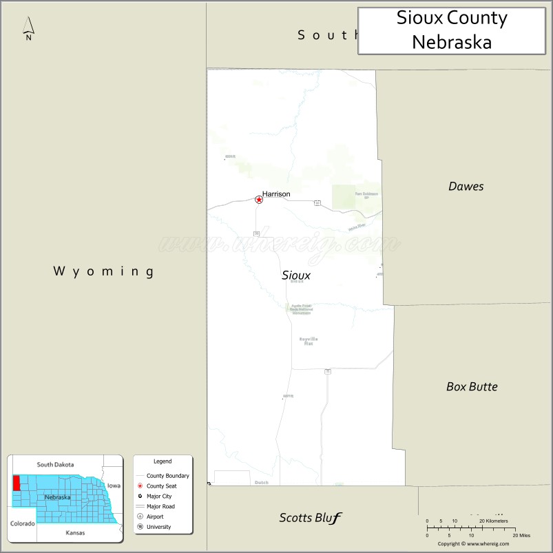
About Sioux County Map, Nebraska: The map showing the county boundary, county seat, major cities, highways, water bodies and neighbouring counties.
Related Nebraska Maps & Info
Map of Sioux County, Nebraska
Sioux County is a county located in the U.S. state of Nebraska. It's county seat is Harrison. As per 2020 census, the population of Sioux County is 1143 people and population density is square miles. According to the United States Census Bureau, the county has a total area of 1,313 sq mi (3,401 km2). Sioux County was established on 1877.
Sioux County Facts
| Continent | North America |
| Country | United States |
| State | Nebraska |
| County Seat | Harrison |
| Largest City/Town | Harrison |
| Established | 1885 |
| Total Area | 2,067 sq mi (5,353 sq km) |
| Land Area | 2,066 sq mi (5,351 sq km) |
| Water Area | 1 sq mi (2.6 sq km) |
| Population | 1,135 (Census 2020) |
| Population Density | 0.5 people per sq mi |
| Time Zone | Mountain Time Zone |
| Major Highways | U.S. Route 20, Nebraska Highway 29, Nebraska Highway 71 |
| Major Rivers | White River, Niobrara River nearby region |
| Neighboring Counties | Dawes County, Box Butte County, Scotts Bluff County, Goshen County (Wyoming), Fall River County (South Dakota) |
| Famous For | Agate Fossil Beds, Pine Ridge landscapes, ranching, and western Nebraska scenery |
| Top Attractions | Agate Fossil Beds National Monument, Hudson-Meng Bison Kill Site, and Warbonnet Creek Battlefield Monument |
| Official Website | Official Website |
About Sioux County, Nebraska
Sioux County is located in the northwestern corner of Nebraska and was established in 1885. The county seat and largest town is Harrison. The county is known for dramatic Pine Ridge landscapes, fossil discoveries, ranching culture, and historical landmarks connected to the American West.
Cities and Towns in Sioux County, Nebraska
| City/Town | Population (Census 2020) | Latitude & Longitude |
|---|---|---|
| Harrison (county seat) | 239 | 42.6872°N, 103.8791°W |
| Agate | 12 | 42.4219°N, 103.7849°W |
| Andrews | 11 | 42.0503°N, 103.9678°W |
Golf Courses in Sioux County, Nebraska
| Golf Course | Location | Latitude & Longitude |
|---|---|---|
| Harrison Golf Club | Harrison | 42.6911°N, 103.8845°W |
| Western Nebraska Prairie Golf Area | Near Harrison | 42.6950°N, 103.8900°W |
Roads and Highways in Sioux County, Nebraska
Major highways connect the county to Wyoming, South Dakota, and western Nebraska regions.
- U.S. Route 20 - major east-west highway crossing northern Nebraska
- Nebraska Highway 29 - scenic route linking Harrison with western Nebraska communities
- Nebraska Highway 71 - north-south route connecting the Panhandle region with Colorado
Neighboring Counties of Sioux County
- Dawes County (east)
- Box Butte County (southeast)
- Scotts Bluff County (south)
- Goshen County, Wyoming (west)
- Fall River County, South Dakota (north)
What Are the Top Attractions in Sioux County, Nebraska
The county offers a mix of historical, geological, and outdoor attractions.
- Agate Fossil Beds National Monument - internationally known fossil site featuring Miocene-era discoveries and scenic trails
- Hudson-Meng Bison Kill Site - archaeological and paleontological site showcasing ancient bison remains
- Warbonnet Creek Battlefield Monument - historic landmark commemorating an Old West military encounter
- Pine Ridge Scenic Areas - dramatic landscapes with buttes, cliffs, and forested ridges
- Ranchland Scenic Drives - countryside routes featuring open grasslands and western Nebraska views
- White River Valley Areas - natural landscapes ideal for wildlife observation and photography
- Harrison Downtown District - local shops, historic buildings, and western Nebraska culture
- Outdoor Recreation Areas - hiking, camping, hunting, horseback riding, and birdwatching opportunities
- Dark Sky Viewing Locations - remote prairie and ridge areas ideal for stargazing and astronomy
- Western Heritage Sites - attractions highlighting pioneer and ranching history in the Nebraska Panhandle
What Is the Distance from Sioux County to Nearby Cities
The following distances are measured by road (driving).
- Harrison to Chadron (Dawes County), Nebraska - 57 mi (92 km)
- Harrison to Scottsbluff (Scotts Bluff County), Nebraska - 79 mi (127 km)
- Harrison to Alliance (Box Butte County), Nebraska - 84 mi (135 km)
- Harrison to Rapid City, South Dakota - 115 mi (185 km)
- Harrison to Cheyenne, Wyoming - 122 mi (196 km)
- Harrison to Casper, Wyoming - 165 mi (266 km)
- Harrison to Denver, Colorado - 232 mi (373 km)
- Harrison to North Platte (Lincoln County), Nebraska - 287 mi (462 km)
- Harrison to Grand Island (Hall County), Nebraska - 418 mi (673 km)
- Harrison to Kearney (Buffalo County), Nebraska - 359 mi (578 km)
- Harrison to Lincoln (Lancaster County), Nebraska - 550 mi (885 km)
- Harrison to Omaha (Douglas County), Nebraska - 604 mi (972 km)
FAQs about Sioux County
Sioux County is located in the northwestern corner of Nebraska.
Sioux County had a population of 1,135 according to Census 2020 data.
Sioux County is known for Agate Fossil Beds, Pine Ridge landscapes, ranching, and western Nebraska scenery.
The county is served by U.S. Route 20, Nebraska Highway 29, and Nebraska Highway 71.
Yes, Sioux County has golf facilities including Harrison Golf Club and prairie golf recreation areas.
References
- QuickFacts - U.S. Census Bureau
- United States Census Bureau
- United States Geological Survey (USGS)
- Agate Fossil Beds National Monument
- Official County Website
- Adams County Map
- Antelope County Map
- Arthur County Map
- Banner County Map
- Blaine County Map
- Boone County Map
- Box Butte County Map
- Boyd County Map
- Brown County Map
- Buffalo County Map
- Burt County Map
- Butler County Map
- Cass County Map
- Cedar County Map
- Chase County Map
- Cherry County Map
- Cheyenne County Map
- Clay County Map
- Colfax County Map
- Cuming County Map
- Custer County Map
- Dakota County Map
- Dawes County Map
- Dawson County Map
- Deuel County Map
- Dixon County Map
- Dodge County Map
- Douglas County Map
- Dundy County Map
- Fillmore County Map
- Franklin County Map
- Frontier County Map
- Furnas County Map
- Gage County Map
- Garden County Map
- Garfield County Map
- Gosper County Map
- Grant County Map
- Greeley County Map
- Hall County Map
- Hamilton County Map
- Harlan County Map
- Hayes County Map
- Hitchcock County Map
- Holt County Map
- Hooker County Map
- Howard County Map
- Jefferson County Map
- Johnson County Map
- Kearney County Map
- Keith County Map
- Keya Paha County Map
- Kimball County Map
- Knox County Map
- Lancaster County Map
- Lincoln County Map
- Logan County Map
- Loup County Map
- McPherson County Map
- Madison County Map
- Merrick County Map
- Morrill County Map
- Nance County Map
- Nemaha County Map
- Nuckolls County Map
- Otoe County Map
- Pawnee County Map
- Perkins County Map
- Phelps County Map
- Pierce County Map
- Platte County Map
- Polk County Map
- Red Willow County Map
- Richardson County Map
- Rock County Map
- Saline County Map
- Sarpy County Map
- Saunders County Map
- Scotts Bluff County Map
- Seward County Map
- Sheridan County Map
- Sherman County Map
- Sioux County Map
- Stanton County Map
- Thayer County Map
- Thomas County Map
- Thurston County Map
- Valley County Map
- Washington County Map
- Wayne County Map
- Webster County Map
- Wheeler County Map
- York County Map
- Alabama Counties
- Alaska boroughs
- Arizona Counties
- Arkansas Counties
- California County Map
- Colorado Counties
- Connecticut Counties
- Delaware Counties
- Florida County Map
- Georgia County Map
- Hawaii Counties
- Idaho Counties
- Illinois Counties
- Indiana Counties
- Iowa Counties
- Kansas Counties
- Kentucky Counties
- Louisiana Counties
- Maine Counties
- Maryland Counties
- Massachusetts Counties
- Michigan County Map
- Minnesota Counties
- Mississippi Counties
- Missouri Counties
- Montana Counties
- Nebraska Counties
- Nevada Counties
- New York Counties
- New Hampshire Counties
- New Jersey Counties
- New Mexico Counties
- North Carolina Counties
- North Dakota Counties
- Ohio County Map
- Oklahoma Counties
- Oregon Counties
- Pennsylvania Counties
- Rhode Island Counties
- South Carolina Counties
- South Dakota Counties
- Map of Tennessee
- Texas County Map
- Utah Counties
- Vermont Counties
- Virginia Counties
- Washington Counties
- West Virginia Counties
- Wisconsin Counties
- Wyoming Counties