Written and Fact-checked by Whereig Editors, Reviewed by Mukesh Kumar| Last Updated On: May 10, 2026
Map of Antelope County - Antelope County is a county located in the U.S. state of Nebraska. Antelope County Map showing cities, highways, important places and water bodies. Get Where is Antelope County located in the map, major cities in Antelope county, population, areas, and places of interest.
Map of Antelope County, Nebraska
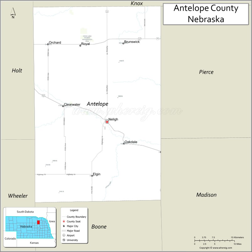
About Antelope County Map, Nebraska: The map showing the county boundary, county seat, major cities, highways, water bodies and neighbouring counties.
Related Nebraska Maps & Info
Map of Antelope County, Nebraska
Antelope County is a county located in the U.S. state of Nebraska. It's county seat is Neligh. As per 2020 census, the population of Antelope County is 6279 people and population density is square miles. According to the United States Census Bureau, the county has a total area of 857 sq mi (2,220 km2). Antelope County was established on 1871.
Antelope County Facts
| Continent | North America |
| Country | United States |
| State | Nebraska |
| County Seat | Neligh |
| Largest City/Town | Neligh |
| Established | 1871 |
| Total Area | 859 sq mi (2,225 sq km) |
| Land Area | 857 sq mi (2,220 sq km) |
| Water Area | 2 sq mi (5 sq km) |
| Population | 6,295 (Census 2020) |
| Population Density | 7.3 people per sq mi |
| Time Zone | Central Time Zone (CT) |
| Major Highways | US 20, NE 14, NE 70 |
| Major Rivers | Elkhorn River |
| Neighboring Counties | Pierce County, Holt County, Boone County, Wheeler County, Madison County, Knox County |
| Famous For | Elkhorn Valley recreation, agriculture, Neligh Mill State Historic Site, prairie landscapes |
| Top Attractions | Neligh Mill State Historic Site, Grove Lake Wildlife Management Area, Elkhorn River recreation, Ashfall Fossil Beds nearby |
| Official Website | Official Website |
About Antelope County, Nebraska
Antelope County is located in northeastern Nebraska in the United States and was established in 1871. The county seat and largest city is Neligh. The county is known for agriculture, scenic prairie landscapes, Elkhorn River recreation, and historic pioneer attractions.
Cities and Towns in Antelope County, Nebraska
| City/Town | Population (Census 2020) | Latitude & Longitude |
|---|---|---|
| Neligh (county seat) | 1,536 | 42.1281°N, 98.0295°W |
| Elgin | 717 | 41.9867°N, 98.0828°W |
| Tilden | 953 | 42.0422°N, 97.8364°W |
| Clearwater | 419 | 42.1764°N, 98.1817°W |
| Oakdale | 307 | 42.0281°N, 97.9664°W |
| Brunswick | 134 | 42.3364°N, 98.0100°W |
Golf Courses in Antelope County, Nebraska
| Golf Course | Location | Latitude & Longitude |
|---|---|---|
| Antelope Country Club | Neligh | 42.1305°N, 98.0412°W |
| Fair Play Golf Course | Tilden | 42.0439°N, 97.8435°W |
| Elkhorn Acres Golf Club nearby | Battle Creek | 41.9951°N, 97.6004°W |
| Norfolk Country Club nearby | Norfolk | 42.0192°N, 97.4298°W |
Roads and Highways in Antelope County, Nebraska
Major highways connect the county to northeastern Nebraska communities and regional agricultural areas.
- US Highway 20 - major east-west highway across northern Nebraska
- Nebraska Highway 14 - important north-south regional route
- Nebraska Highway 70 - roadway serving local prairie communities
Neighboring Counties of Antelope County
- Knox County (north)
- Pierce County (east)
- Madison County (southeast)
- Boone County (south)
- Wheeler County (southwest)
- Holt County (west)
What Are the Top Attractions in Antelope County, Nebraska
The county offers a mix of prairie recreation, historic attractions, and outdoor Nebraska experiences.
- Neligh Mill State Historic Site - restored flour mill and pioneer history attraction
- Grove Lake Wildlife Management Area - fishing, camping, and wildlife viewing
- Elkhorn River recreation - kayaking, fishing, canoeing, and nature activities
- Ashfall Fossil Beds nearby - prehistoric fossil discovery site and educational attraction
- Antelope Country Club - golf and recreation facility
- Historic downtown Neligh - local shops, restaurants, and community events
- Prairie scenic drives - rolling farmland and countryside landscapes
- Birdwatching and wildlife habitats - prairie wetlands and migratory bird viewing
- Camping and RV parks throughout the county - outdoor recreation destinations
- Photography and sunset viewing across Nebraska prairies - scenic outdoor experiences
- Regional fairs and rodeos - celebrating agriculture and local traditions
- Fishing and hunting opportunities - pheasant, deer, and waterfowl recreation
- Historic churches and pioneer landmarks - reflecting early Nebraska settlement history
- Nearby Norfolk attractions - museums, shopping, and entertainment venues
What Is the Distance from Antelope County to Nearby Cities
The following distances are measured by road (driving).
- Neligh to Norfolk (Madison County), Nebraska - 39 mi (63 km)
- Neligh to O'Neill (Holt County), Nebraska - 44 mi (71 km)
- Neligh to Columbus (Platte County), Nebraska - 89 mi (143 km)
- Neligh to Sioux City (Woodbury County), Iowa - 121 mi (195 km)
- Neligh to Lincoln (Lancaster County), Nebraska - 161 mi (259 km)
- Neligh to Omaha (Douglas County), Nebraska - 166 mi (267 km)
- Neligh to Sioux Falls (Minnehaha County), South Dakota - 167 mi (269 km)
- Neligh to Pierre (Hughes County), South Dakota - 278 mi (447 km)
- Neligh to North Platte (Lincoln County), Nebraska - 230 mi (370 km)
- Neligh to Denver (Denver County), Colorado - 476 mi (766 km)
- Neligh to Minneapolis (Hennepin County), Minnesota - 380 mi (612 km)
- Neligh to Fargo (Cass County), North Dakota - 410 mi (660 km)
FAQs about Antelope County
Antelope County is located in northeastern Nebraska in the Elkhorn River Valley region.
Antelope County had a population of 6,295 according to the 2020 United States Census.
Antelope County is known for agriculture, Elkhorn River recreation, prairie landscapes, and historic attractions.
The major highways include US Highway 20, Nebraska Highway 14, and Nebraska Highway 70.
Popular attractions include Neligh Mill State Historic Site, Grove Lake Wildlife Management Area, and Elkhorn River recreation.
References
- QuickFacts - U.S. Census Bureau
- United States Census Bureau
- United States Geological Survey (USGS)
- National Geodetic Survey
- Official Website
- Adams County Map
- Antelope County Map
- Arthur County Map
- Banner County Map
- Blaine County Map
- Boone County Map
- Box Butte County Map
- Boyd County Map
- Brown County Map
- Buffalo County Map
- Burt County Map
- Butler County Map
- Cass County Map
- Cedar County Map
- Chase County Map
- Cherry County Map
- Cheyenne County Map
- Clay County Map
- Colfax County Map
- Cuming County Map
- Custer County Map
- Dakota County Map
- Dawes County Map
- Dawson County Map
- Deuel County Map
- Dixon County Map
- Dodge County Map
- Douglas County Map
- Dundy County Map
- Fillmore County Map
- Franklin County Map
- Frontier County Map
- Furnas County Map
- Gage County Map
- Garden County Map
- Garfield County Map
- Gosper County Map
- Grant County Map
- Greeley County Map
- Hall County Map
- Hamilton County Map
- Harlan County Map
- Hayes County Map
- Hitchcock County Map
- Holt County Map
- Hooker County Map
- Howard County Map
- Jefferson County Map
- Johnson County Map
- Kearney County Map
- Keith County Map
- Keya Paha County Map
- Kimball County Map
- Knox County Map
- Lancaster County Map
- Lincoln County Map
- Logan County Map
- Loup County Map
- McPherson County Map
- Madison County Map
- Merrick County Map
- Morrill County Map
- Nance County Map
- Nemaha County Map
- Nuckolls County Map
- Otoe County Map
- Pawnee County Map
- Perkins County Map
- Phelps County Map
- Pierce County Map
- Platte County Map
- Polk County Map
- Red Willow County Map
- Richardson County Map
- Rock County Map
- Saline County Map
- Sarpy County Map
- Saunders County Map
- Scotts Bluff County Map
- Seward County Map
- Sheridan County Map
- Sherman County Map
- Sioux County Map
- Stanton County Map
- Thayer County Map
- Thomas County Map
- Thurston County Map
- Valley County Map
- Washington County Map
- Wayne County Map
- Webster County Map
- Wheeler County Map
- York County Map
- Alabama Counties
- Alaska boroughs
- Arizona Counties
- Arkansas Counties
- California County Map
- Colorado Counties
- Connecticut Counties
- Delaware Counties
- Florida County Map
- Georgia County Map
- Hawaii Counties
- Idaho Counties
- Illinois Counties
- Indiana Counties
- Iowa Counties
- Kansas Counties
- Kentucky Counties
- Louisiana Counties
- Maine Counties
- Maryland Counties
- Massachusetts Counties
- Michigan County Map
- Minnesota Counties
- Mississippi Counties
- Missouri Counties
- Montana Counties
- Nebraska Counties
- Nevada Counties
- New York Counties
- New Hampshire Counties
- New Jersey Counties
- New Mexico Counties
- North Carolina Counties
- North Dakota Counties
- Ohio County Map
- Oklahoma Counties
- Oregon Counties
- Pennsylvania Counties
- Rhode Island Counties
- South Carolina Counties
- South Dakota Counties
- Map of Tennessee
- Texas County Map
- Utah Counties
- Vermont Counties
- Virginia Counties
- Washington Counties
- West Virginia Counties
- Wisconsin Counties
- Wyoming Counties