Written and Fact-checked by Whereig Editors, Reviewed by Mukesh Kumar| Last Updated On: May 10, 2026
Map of Pawnee County - Pawnee County is a county located in the U.S. state of Nebraska. Pawnee County Map showing cities, highways, important places and water bodies. Get Where is Pawnee County located in the map, major cities in Pawnee county, population, areas, and places of interest.
Map of Pawnee County, Nebraska
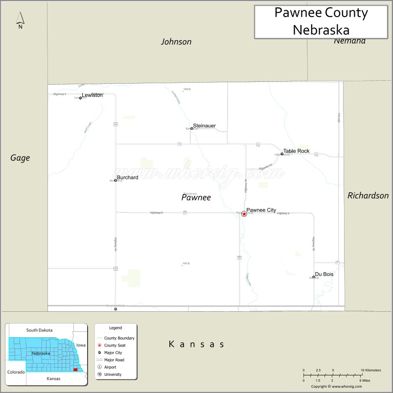
About Pawnee County Map, Nebraska: The map showing the county boundary, county seat, major cities, highways, water bodies and neighbouring counties.
Related Nebraska Maps & Info
Map of Pawnee County, Nebraska
Pawnee County is a county located in the U.S. state of Nebraska. It's county seat is Pawnee City. As per 2020 census, the population of Pawnee County is 2548 people and population density is square miles. According to the United States Census Bureau, the county has a total area of 432 sq mi (1,119 km2). Pawnee County was established on 1855.
Pawnee County Facts
| Continent | North America |
| Country | United States |
| State | Nebraska |
| County Seat | Pawnee City |
| Largest City/Town | Pawnee City |
| Established | 1854 |
| Total Area | 432 sq mi (1,119 sq km) |
| Land Area | 431 sq mi (1,116 sq km) |
| Water Area | 1 sq mi (2.6 sq km) |
| Population | 2,544 (Census 2020) |
| Population Density | 5.9 people per sq mi |
| Time Zone | Central Time Zone |
| Major Highways | U.S. Route 50, Nebraska Highway 8, Nebraska Highway 65 |
| Major Rivers | Big Nemaha River |
| Neighboring Counties | Johnson County, Richardson County, Gage County, Marshall County (Kansas) |
| Famous For | Agriculture, rolling prairie landscapes, and historic southeastern Nebraska communities |
| Top Attractions | Pawnee County Historical Museum, Pawnee Lake Recreation Area, and Pawnee City historic district |
| Official Website | Official Website |
About Pawnee County, Nebraska
Pawnee County is located in southeastern Nebraska along the Kansas border and was established in 1854. The county seat is Pawnee City, which is also the largest city in the county. The county is known for agriculture, scenic prairie landscapes, small-town heritage, and community traditions rooted in Nebraska pioneer history.
Cities and Towns in Pawnee County, Nebraska
| City/Town | Population (Census 2020) | Latitude & Longitude |
|---|---|---|
| Pawnee City (county seat) | 865 | 40.1086°N, 96.1536°W |
| Burchard | 82 | 40.1394°N, 96.2850°W |
| Du Bois | 95 | 40.0375°N, 96.0403°W |
| Lewiston | 54 | 40.2464°N, 96.4017°W |
| Steinauer | 63 | 40.2053°N, 96.2211°W |
| Table Rock | 233 | 40.1786°N, 96.0811°W |
Golf Courses in Pawnee County, Nebraska
| Golf Course | Location | Latitude & Longitude |
|---|---|---|
| Pawnee City Country Club | Pawnee City | 40.1111°N, 96.1582°W |
| Table Rock Golf Course | Table Rock | 40.1810°N, 96.0860°W |
Roads and Highways in Pawnee County, Nebraska
Major highways connect the county to nearby communities and states.
- U.S. Route 50 - north-south highway linking southeastern Nebraska with Kansas and Omaha regions
- Nebraska Highway 8 - east-west route serving rural communities across southern Nebraska
- Nebraska Highway 65 - regional route connecting agricultural communities within the county
Neighboring Counties of Pawnee County
- Johnson County (north)
- Gage County (west)
- Richardson County (east)
- Marshall County, Kansas (south)
What Are the Top Attractions in Pawnee County, Nebraska
The county offers a mix of cultural, historical, and outdoor attractions.
- Pawnee County Historical Museum - exhibits showcasing pioneer history and local heritage
- Pawnee Lake Recreation Area - outdoor destination for fishing, boating, camping, and picnics
- Pawnee City Historic District - local shops, restaurants, and historic architecture
- Big Nemaha River Scenic Areas - natural landscapes supporting wildlife viewing and photography
- Table Rock Community Parks - recreation areas with sports facilities and picnic grounds
- Steinauer Prairie Landscapes - scenic countryside featuring rolling farmland and open views
- Burchard Historic Sites - small-town landmarks reflecting Nebraska pioneer culture
- Pawnee County Fairgrounds - venue for county fairs, livestock shows, and local festivals
- Lewiston Rural Scenic Drives - countryside routes with prairie and agricultural scenery
- Outdoor Recreation Areas - birdwatching, hiking, and nature observation opportunities
What Is the Distance from Pawnee County to Nearby Cities
The following distances are measured by road (driving).
- Pawnee City to Beatrice (Gage County), Nebraska - 44 mi (71 km)
- Pawnee City to Auburn (Nemaha County), Nebraska - 31 mi (50 km)
- Pawnee City to Nebraska City (Otoe County), Nebraska - 62 mi (100 km)
- Pawnee City to Lincoln (Lancaster County), Nebraska - 77 mi (124 km)
- Pawnee City to Omaha (Douglas County), Nebraska - 101 mi (163 km)
- Pawnee City to Marysville, Kansas - 31 mi (50 km)
- Pawnee City to Topeka, Kansas - 96 mi (154 km)
- Pawnee City to Kansas City, Missouri - 138 mi (222 km)
- Pawnee City to Grand Island (Hall County), Nebraska - 154 mi (248 km)
- Pawnee City to Kearney (Buffalo County), Nebraska - 191 mi (307 km)
- Pawnee City to North Platte (Lincoln County), Nebraska - 295 mi (475 km)
- Pawnee City to Denver, Colorado - 550 mi (885 km)
FAQs about Pawnee County
Pawnee County is located in southeastern Nebraska along the Kansas border.
Pawnee County had a population of 2,544 according to Census 2020 data.
Pawnee County is known for agriculture, prairie scenery, and historic small-town communities.
The county is served by U.S. Route 50, Nebraska Highway 8, and Nebraska Highway 65.
Yes, Pawnee County has golf facilities including Pawnee City Country Club and Table Rock Golf Course.
References
- QuickFacts - U.S. Census Bureau
- United States Census Bureau
- United States Geological Survey (USGS)
- National Geodetic Survey
- Official County Website
- Adams County Map
- Antelope County Map
- Arthur County Map
- Banner County Map
- Blaine County Map
- Boone County Map
- Box Butte County Map
- Boyd County Map
- Brown County Map
- Buffalo County Map
- Burt County Map
- Butler County Map
- Cass County Map
- Cedar County Map
- Chase County Map
- Cherry County Map
- Cheyenne County Map
- Clay County Map
- Colfax County Map
- Cuming County Map
- Custer County Map
- Dakota County Map
- Dawes County Map
- Dawson County Map
- Deuel County Map
- Dixon County Map
- Dodge County Map
- Douglas County Map
- Dundy County Map
- Fillmore County Map
- Franklin County Map
- Frontier County Map
- Furnas County Map
- Gage County Map
- Garden County Map
- Garfield County Map
- Gosper County Map
- Grant County Map
- Greeley County Map
- Hall County Map
- Hamilton County Map
- Harlan County Map
- Hayes County Map
- Hitchcock County Map
- Holt County Map
- Hooker County Map
- Howard County Map
- Jefferson County Map
- Johnson County Map
- Kearney County Map
- Keith County Map
- Keya Paha County Map
- Kimball County Map
- Knox County Map
- Lancaster County Map
- Lincoln County Map
- Logan County Map
- Loup County Map
- McPherson County Map
- Madison County Map
- Merrick County Map
- Morrill County Map
- Nance County Map
- Nemaha County Map
- Nuckolls County Map
- Otoe County Map
- Pawnee County Map
- Perkins County Map
- Phelps County Map
- Pierce County Map
- Platte County Map
- Polk County Map
- Red Willow County Map
- Richardson County Map
- Rock County Map
- Saline County Map
- Sarpy County Map
- Saunders County Map
- Scotts Bluff County Map
- Seward County Map
- Sheridan County Map
- Sherman County Map
- Sioux County Map
- Stanton County Map
- Thayer County Map
- Thomas County Map
- Thurston County Map
- Valley County Map
- Washington County Map
- Wayne County Map
- Webster County Map
- Wheeler County Map
- York County Map
- Alabama Counties
- Alaska boroughs
- Arizona Counties
- Arkansas Counties
- California County Map
- Colorado Counties
- Connecticut Counties
- Delaware Counties
- Florida County Map
- Georgia County Map
- Hawaii Counties
- Idaho Counties
- Illinois Counties
- Indiana Counties
- Iowa Counties
- Kansas Counties
- Kentucky Counties
- Louisiana Counties
- Maine Counties
- Maryland Counties
- Massachusetts Counties
- Michigan County Map
- Minnesota Counties
- Mississippi Counties
- Missouri Counties
- Montana Counties
- Nebraska Counties
- Nevada Counties
- New York Counties
- New Hampshire Counties
- New Jersey Counties
- New Mexico Counties
- North Carolina Counties
- North Dakota Counties
- Ohio County Map
- Oklahoma Counties
- Oregon Counties
- Pennsylvania Counties
- Rhode Island Counties
- South Carolina Counties
- South Dakota Counties
- Map of Tennessee
- Texas County Map
- Utah Counties
- Vermont Counties
- Virginia Counties
- Washington Counties
- West Virginia Counties
- Wisconsin Counties
- Wyoming Counties