Written and Fact-checked by Whereig Editors, Reviewed by Mukesh Kumar| Last Updated On: May 10, 2026
Map of Buffalo County - Buffalo County is a county located in the U.S. state of Nebraska. Buffalo County Map showing cities, highways, important places and water bodies. Get Where is Buffalo County located in the map, major cities in Buffalo county, population, areas, and places of interest.
Map of Buffalo County, Nebraska
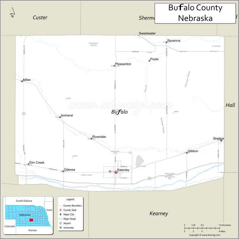
About Buffalo County Map, Nebraska: The map showing the county boundary, county seat, major cities, highways, water bodies and neighbouring counties.
Related Nebraska Maps & Info
Map of Buffalo County, Nebraska
Buffalo County is a county located in the U.S. state of Nebraska. It's county seat is Kearney. As per 2020 census, the population of Buffalo County is 50339 people and population density is square miles. According to the United States Census Bureau, the county has a total area of 968 sq mi (2,507 km2). Buffalo County was established on 1855.
Buffalo County Facts
| Continent | North America |
| Country | United States |
| State | Nebraska |
| County Seat | Kearney |
| Largest City/Town | Kearney |
| Established | 1855 |
| Total Area | 984 sq mi (2,549 sq km) |
| Land Area | 968 sq mi (2,507 sq km) |
| Water Area | 16 sq mi (41 sq km) |
| Population | 50,231 (Census 2020) |
| Population Density | 51.9 people per sq mi |
| Time Zone | Central Time Zone (CT) |
| Major Highways | Interstate 80, US 30, US 183, NE 10 |
| Major Rivers | Platte River |
| Neighboring Counties | Hall County, Sherman County, Dawson County, Custer County, Phelps County, Adams County |
| Famous For | Sandhill crane migration, University of Nebraska at Kearney, Platte River recreation, agriculture |
| Top Attractions | Great Platte River Road Archway Monument, Rowe Sanctuary, Yanney Heritage Park, Fort Kearny State Historical Park |
| Official Website | Official Website |
About Buffalo County, Nebraska
Buffalo County is located in south-central Nebraska in the United States and was established in 1855. The county seat and largest city is Kearney. The county is known for Sandhill crane migration, higher education, Platte River recreation, agriculture, and historic Oregon Trail heritage.
Cities and Towns in Buffalo County, Nebraska
| City/Town | Population (Census 2020) | Latitude & Longitude |
|---|---|---|
| Kearney (county seat) | 33,790 | 40.6995°N, 99.0815°W |
| Gibbon | 1,852 | 40.7489°N, 98.8445°W |
| Shelton | 1,059 | 40.7797°N, 98.7304°W |
| Ravenna | 1,360 | 41.0264°N, 98.9126°W |
| Pleasanton | 341 | 40.9667°N, 99.0834°W |
| Miller | 136 | 40.9433°N, 99.3881°W |
Golf Courses in Buffalo County, Nebraska
| Golf Course | Location | Latitude & Longitude |
|---|---|---|
| Meadowlark Hills Golf Course | Kearney | 40.7118°N, 99.0937°W |
| Kearney Country Club | Kearney | 40.6902°N, 99.0758°W |
| Awarii Dunes Golf Club nearby | Kearney | 40.7454°N, 99.2068°W |
| Ravenna Country Club | Ravenna | 41.0287°N, 98.9215°W |
Roads and Highways in Buffalo County, Nebraska
Major highways connect the county to central Nebraska communities and national transportation routes.
- Interstate 80 - major east-west interstate across Nebraska
- US Highway 30 - historic Lincoln Highway route through the Platte River Valley
- US Highway 183 - important north-south transportation corridor
- Nebraska Highway 10 - regional roadway serving local communities
Neighboring Counties of Buffalo County
- Sherman County (north)
- Hall County (east)
- Adams County (southeast)
- Phelps County (south)
- Dawson County (west)
- Custer County (northwest)
What Are the Top Attractions in Buffalo County, Nebraska
The county offers a mix of Platte River recreation, wildlife attractions, historic sites, and family entertainment.
- Great Platte River Road Archway Monument - interactive museum over Interstate 80 showcasing pioneer history
- Rowe Sanctuary - world-famous Sandhill crane migration viewing destination
- Yanney Heritage Park - lakes, trails, playgrounds, and family recreation
- Fort Kearny State Historical Park - Oregon Trail and frontier military history attraction
- University of Nebraska at Kearney campus attractions - educational and cultural events
- Meadowlark Hills Golf Course - golf and recreation facility
- Platte River recreation - fishing, kayaking, wildlife viewing, and scenic outdoor experiences
- Classic Car Collection museum - antique and classic automobile exhibits
- Birdwatching and wildlife habitats - migratory cranes and prairie ecosystems
- Camping and RV parks throughout the county - outdoor recreation destinations
- Historic downtown Kearney - restaurants, shopping, breweries, and entertainment venues
- Photography and sunset viewing along the Platte River - scenic Nebraska landscapes
- Regional fairs and festivals - celebrating agriculture and Nebraska traditions
- Fishing and hunting opportunities - outdoor recreation throughout the county
What Is the Distance from Buffalo County to Nearby Cities
The following distances are measured by road (driving).
- Kearney to Grand Island (Hall County), Nebraska - 42 mi (68 km)
- Kearney to North Platte (Lincoln County), Nebraska - 111 mi (179 km)
- Kearney to Hastings (Adams County), Nebraska - 42 mi (68 km)
- Kearney to Lincoln (Lancaster County), Nebraska - 131 mi (211 km)
- Kearney to Omaha (Douglas County), Nebraska - 187 mi (301 km)
- Kearney to Sioux Falls (Minnehaha County), South Dakota - 287 mi (462 km)
- Kearney to Denver (Denver County), Colorado - 317 mi (510 km)
- Kearney to Wichita (Sedgwick County), Kansas - 309 mi (497 km)
- Kearney to Pierre (Hughes County), South Dakota - 323 mi (520 km)
- Kearney to Kansas City (Jackson County), Missouri - 349 mi (562 km)
- Kearney to Minneapolis (Hennepin County), Minnesota - 472 mi (760 km)
- Kearney to Fargo (Cass County), North Dakota - 552 mi (888 km)
FAQs about Buffalo County
Buffalo County is located in south-central Nebraska along the Platte River.
Buffalo County had a population of 50,231 according to the 2020 United States Census.
Buffalo County is known for Sandhill crane migration, Platte River recreation, the University of Nebraska at Kearney, and pioneer history.
The major highways include Interstate 80, US Highway 30, US Highway 183, and Nebraska Highway 10.
Popular attractions include the Great Platte River Road Archway Monument, Rowe Sanctuary, Yanney Heritage Park, and Fort Kearny State Historical Park.
References
- QuickFacts - U.S. Census Bureau
- United States Census Bureau
- United States Geological Survey (USGS)
- National Geodetic Survey
- Official Website
- Adams County Map
- Antelope County Map
- Arthur County Map
- Banner County Map
- Blaine County Map
- Boone County Map
- Box Butte County Map
- Boyd County Map
- Brown County Map
- Buffalo County Map
- Burt County Map
- Butler County Map
- Cass County Map
- Cedar County Map
- Chase County Map
- Cherry County Map
- Cheyenne County Map
- Clay County Map
- Colfax County Map
- Cuming County Map
- Custer County Map
- Dakota County Map
- Dawes County Map
- Dawson County Map
- Deuel County Map
- Dixon County Map
- Dodge County Map
- Douglas County Map
- Dundy County Map
- Fillmore County Map
- Franklin County Map
- Frontier County Map
- Furnas County Map
- Gage County Map
- Garden County Map
- Garfield County Map
- Gosper County Map
- Grant County Map
- Greeley County Map
- Hall County Map
- Hamilton County Map
- Harlan County Map
- Hayes County Map
- Hitchcock County Map
- Holt County Map
- Hooker County Map
- Howard County Map
- Jefferson County Map
- Johnson County Map
- Kearney County Map
- Keith County Map
- Keya Paha County Map
- Kimball County Map
- Knox County Map
- Lancaster County Map
- Lincoln County Map
- Logan County Map
- Loup County Map
- McPherson County Map
- Madison County Map
- Merrick County Map
- Morrill County Map
- Nance County Map
- Nemaha County Map
- Nuckolls County Map
- Otoe County Map
- Pawnee County Map
- Perkins County Map
- Phelps County Map
- Pierce County Map
- Platte County Map
- Polk County Map
- Red Willow County Map
- Richardson County Map
- Rock County Map
- Saline County Map
- Sarpy County Map
- Saunders County Map
- Scotts Bluff County Map
- Seward County Map
- Sheridan County Map
- Sherman County Map
- Sioux County Map
- Stanton County Map
- Thayer County Map
- Thomas County Map
- Thurston County Map
- Valley County Map
- Washington County Map
- Wayne County Map
- Webster County Map
- Wheeler County Map
- York County Map
- Alabama Counties
- Alaska boroughs
- Arizona Counties
- Arkansas Counties
- California County Map
- Colorado Counties
- Connecticut Counties
- Delaware Counties
- Florida County Map
- Georgia County Map
- Hawaii Counties
- Idaho Counties
- Illinois Counties
- Indiana Counties
- Iowa Counties
- Kansas Counties
- Kentucky Counties
- Louisiana Counties
- Maine Counties
- Maryland Counties
- Massachusetts Counties
- Michigan County Map
- Minnesota Counties
- Mississippi Counties
- Missouri Counties
- Montana Counties
- Nebraska Counties
- Nevada Counties
- New York Counties
- New Hampshire Counties
- New Jersey Counties
- New Mexico Counties
- North Carolina Counties
- North Dakota Counties
- Ohio County Map
- Oklahoma Counties
- Oregon Counties
- Pennsylvania Counties
- Rhode Island Counties
- South Carolina Counties
- South Dakota Counties
- Map of Tennessee
- Texas County Map
- Utah Counties
- Vermont Counties
- Virginia Counties
- Washington Counties
- West Virginia Counties
- Wisconsin Counties
- Wyoming Counties