Written and Fact-checked by Whereig Editors, Reviewed by Mukesh Kumar| Last Updated On: May 10, 2026
Map of Grant County - Grant County is a county located in the U.S. state of Nebraska. Grant County Map showing cities, highways, important places and water bodies. Get Where is Grant County located in the map, major cities in Grant county, population, areas, and places of interest.
Map of Grant County, Nebraska
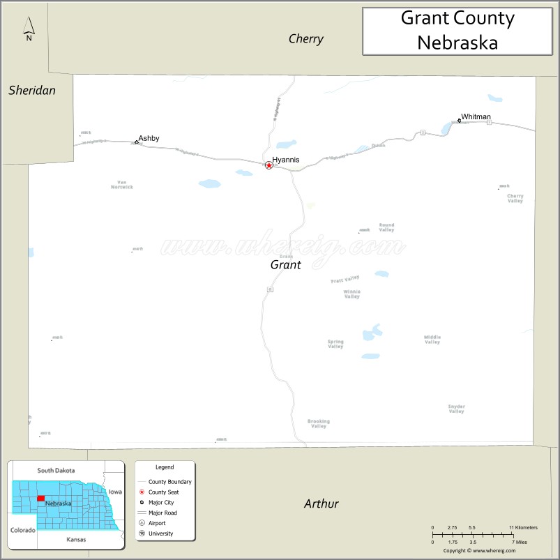
About Grant County Map, Nebraska: The map showing the county boundary, county seat, major cities, highways, water bodies and neighbouring counties.
Related Nebraska Maps & Info
Map of Grant County, Nebraska
Grant County is a county located in the U.S. state of Nebraska. It's county seat is Hyannis. As per 2020 census, the population of Grant County is 579 people and population density is square miles. According to the United States Census Bureau, the county has a total area of 776 sq mi (2,010 km2). Grant County was established on 1887.
Grant County Facts
| Continent | North America |
| Country | United States |
| State | Nebraska |
| County Seat | Hyannis |
| Largest City/Town | Hyannis |
| Established | 1887 |
| Total Area | 783 sq mi (2,028 sq km) |
| Land Area | 776 sq mi (2,010 sq km) |
| Water Area | 7 sq mi (18 sq km) |
| Population | 611 (Census 2020) |
| Population Density | 0.8 people per sq mi |
| Time Zone | Mountain Time Zone |
| Major Highways | Nebraska Highway 2, Nebraska Highway 61 |
| Major Rivers | North Loup River |
| Neighboring Counties | Cherry County, Hooker County, Arthur County, Garden County, Sheridan County |
| Famous For | Sandhills ranching, prairie landscapes, and outdoor recreation |
| Top Attractions | Whitman Lake, Nebraska Sandhills scenery, and Hyannis area recreation |
| Official Website | Official Website |
About Grant County, Nebraska
Grant County is located in the western Sandhills region of Nebraska in the United States and was established in 1887. The county seat is Hyannis, which is also the largest community in the county. The county is known for cattle ranching, rolling prairie dunes, scenic grasslands, and quiet rural landscapes that are part of the Nebraska Sandhills.
Cities and Towns in Grant County, Nebraska
| City/Town | Population (Census 2020) | Latitude & Longitude |
|---|---|---|
| Hyannis (county seat) | 165 | 42.0035°N, 101.7610°W |
| Ashby | 24 | 41.9938°N, 101.9840°W |
Golf Courses in Grant County, Nebraska
| Golf Course | Location | Latitude & Longitude |
|---|---|---|
| Hyannis Golf Course | Hyannis | 42.0020°N, 101.7562°W |
Roads and Highways in Grant County, Nebraska
Major highways connect the county to nearby regions and cities.
- Nebraska Highway 2 - major east-west route crossing the Sandhills and linking Hyannis with Alliance and Broken Bow
- Nebraska Highway 61 - north-south route connecting Grant County with Arthur County and Garden County
Neighboring Counties of Grant County
- Cherry County (north)
- Hooker County (east)
- Arthur County (south)
- Garden County (southwest)
- Sheridan County (west)
What Are the Top Attractions in Grant County, Nebraska
The county offers a mix of natural and cultural attractions.
- Whitman Lake - scenic lake area popular for fishing, boating, and birdwatching
- Nebraska Sandhills - vast prairie landscape with rolling dunes and ranchlands
- Hyannis Community Park - local recreation area with picnic facilities and open green space
- North Loup River Area - quiet natural setting for wildlife viewing and photography
- Ashby Area Prairie Roads - scenic rural drives through open grasslands and ranch country
- Grant County Historical Displays - exhibits showcasing pioneer and ranching history
- Sandhills Ranchlands - wide-open landscapes reflecting traditional Nebraska cattle ranching
- Whitman Wildlife Habitat - area known for native birds and prairie wildlife
- Nebraska Highway 2 Scenic Route - one of the most scenic drives across the Sandhills region
What Is the Distance from Grant County to Nearby Cities
The following distances are measured by road (driving).
- Hyannis to Alliance (Box Butte County), Nebraska - 61 mi (98 km)
- Hyannis to Mullen (Hooker County), Nebraska - 52 mi (84 km)
- Hyannis to Arthur (Arthur County), Nebraska - 45 mi (72 km)
- Hyannis to Oshkosh (Garden County), Nebraska - 71 mi (114 km)
- Hyannis to Valentine (Cherry County), Nebraska - 108 mi (174 km)
- Hyannis to Broken Bow (Custer County), Nebraska - 141 mi (227 km)
- Hyannis to North Platte (Lincoln County), Nebraska - 142 mi (229 km)
- Hyannis to Scottsbluff (Scotts Bluff County), Nebraska - 118 mi (190 km)
- Hyannis to Chadron (Dawes County), Nebraska - 98 mi (158 km)
- Hyannis to Sidney (Cheyenne County), Nebraska - 131 mi (211 km)
- Hyannis to Lincoln (Lancaster County), Nebraska - 314 mi (505 km)
- Hyannis to Denver, Colorado - 267 mi (430 km)
FAQs about Grant County
Grant County is located in the western Sandhills region of Nebraska in the United States.
Grant County had a population of 611 according to Census 2020 data.
Grant County is known for cattle ranching, Sandhills scenery, prairie landscapes, and outdoor recreation.
The main highways in Grant County are Nebraska Highway 2 and Nebraska Highway 61.
Yes, Grant County has the Hyannis Golf Course located near Hyannis.
References
- QuickFacts - U.S. Census Bureau
- United States Census Bureau
- United States Geological Survey (USGS)
- National Geodetic Survey
- Official County Website
- Adams County Map
- Antelope County Map
- Arthur County Map
- Banner County Map
- Blaine County Map
- Boone County Map
- Box Butte County Map
- Boyd County Map
- Brown County Map
- Buffalo County Map
- Burt County Map
- Butler County Map
- Cass County Map
- Cedar County Map
- Chase County Map
- Cherry County Map
- Cheyenne County Map
- Clay County Map
- Colfax County Map
- Cuming County Map
- Custer County Map
- Dakota County Map
- Dawes County Map
- Dawson County Map
- Deuel County Map
- Dixon County Map
- Dodge County Map
- Douglas County Map
- Dundy County Map
- Fillmore County Map
- Franklin County Map
- Frontier County Map
- Furnas County Map
- Gage County Map
- Garden County Map
- Garfield County Map
- Gosper County Map
- Grant County Map
- Greeley County Map
- Hall County Map
- Hamilton County Map
- Harlan County Map
- Hayes County Map
- Hitchcock County Map
- Holt County Map
- Hooker County Map
- Howard County Map
- Jefferson County Map
- Johnson County Map
- Kearney County Map
- Keith County Map
- Keya Paha County Map
- Kimball County Map
- Knox County Map
- Lancaster County Map
- Lincoln County Map
- Logan County Map
- Loup County Map
- McPherson County Map
- Madison County Map
- Merrick County Map
- Morrill County Map
- Nance County Map
- Nemaha County Map
- Nuckolls County Map
- Otoe County Map
- Pawnee County Map
- Perkins County Map
- Phelps County Map
- Pierce County Map
- Platte County Map
- Polk County Map
- Red Willow County Map
- Richardson County Map
- Rock County Map
- Saline County Map
- Sarpy County Map
- Saunders County Map
- Scotts Bluff County Map
- Seward County Map
- Sheridan County Map
- Sherman County Map
- Sioux County Map
- Stanton County Map
- Thayer County Map
- Thomas County Map
- Thurston County Map
- Valley County Map
- Washington County Map
- Wayne County Map
- Webster County Map
- Wheeler County Map
- York County Map
- Alabama Counties
- Alaska boroughs
- Arizona Counties
- Arkansas Counties
- California County Map
- Colorado Counties
- Connecticut Counties
- Delaware Counties
- Florida County Map
- Georgia County Map
- Hawaii Counties
- Idaho Counties
- Illinois Counties
- Indiana Counties
- Iowa Counties
- Kansas Counties
- Kentucky Counties
- Louisiana Counties
- Maine Counties
- Maryland Counties
- Massachusetts Counties
- Michigan County Map
- Minnesota Counties
- Mississippi Counties
- Missouri Counties
- Montana Counties
- Nebraska Counties
- Nevada Counties
- New York Counties
- New Hampshire Counties
- New Jersey Counties
- New Mexico Counties
- North Carolina Counties
- North Dakota Counties
- Ohio County Map
- Oklahoma Counties
- Oregon Counties
- Pennsylvania Counties
- Rhode Island Counties
- South Carolina Counties
- South Dakota Counties
- Map of Tennessee
- Texas County Map
- Utah Counties
- Vermont Counties
- Virginia Counties
- Washington Counties
- West Virginia Counties
- Wisconsin Counties
- Wyoming Counties