Written and Fact-checked by Whereig Editors, Reviewed by Mukesh Kumar| Last Updated On: May 10, 2026
Map of Garfield County - Garfield County is a county located in the U.S. state of Nebraska. Garfield County Map showing cities, highways, important places and water bodies. Get Where is Garfield County located in the map, major cities in Garfield county, population, areas, and places of interest.
Map of Garfield County, Nebraska
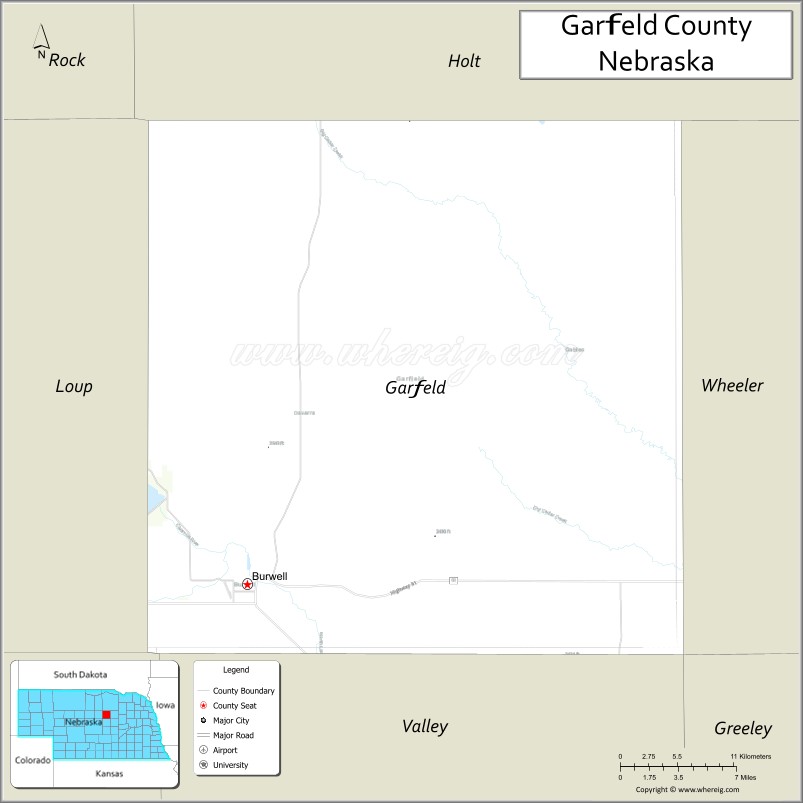
About Garfield County Map, Nebraska: The map showing the county boundary, county seat, major cities, highways, water bodies and neighbouring counties.
Related Nebraska Maps & Info
Map of Garfield County, Nebraska
Garfield County is a county located in the U.S. state of Nebraska. It's county seat is Burwell. As per 2020 census, the population of Garfield County is 1839 people and population density is square miles. According to the United States Census Bureau, the county has a total area of 570 sq mi (1,476 km2). Garfield County was established on 1884.
Garfield County Facts
| Continent | North America |
| Country | United States |
| State | Nebraska |
| County Seat | Burwell |
| Largest City/Town | Burwell |
| Established | 1884 |
| Total Area | 571 sq mi (1,479 sq km) |
| Land Area | 570 sq mi (1,476 sq km) |
| Water Area | 1 sq mi (3 sq km) |
| Population | 1,813 (Census 2020) |
| Population Density | 3.2 people per sq mi |
| Time Zone | Central Time Zone (CT) |
| Major Highways | NE 11, NE 70, NE 91 |
| Major Rivers | Calamus River, North Loup River |
| Neighboring Counties | Holt County, Wheeler County, Loup County, Valley County, Greeley County |
| Famous For | Nebraska Sandhills, Calamus Reservoir nearby, rodeos, outdoor recreation |
| Top Attractions | Calamus State Recreation Area, Burwell Rodeo, Nebraska’s Big Rodeo, Sandhills scenic drives |
| Official Website | Official Website |
About Garfield County, Nebraska
Garfield County is located in central Nebraska in the United States and was established in 1884. The county seat and largest city is Burwell. The county is known for Sandhills landscapes, ranching traditions, rodeo culture, and outdoor recreation around the Calamus River and nearby reservoirs.
Cities and Towns in Garfield County, Nebraska
| City/Town | Population (Census 2020) | Latitude & Longitude |
|---|---|---|
| Burwell (county seat) | 1,087 | 41.7842°N, 99.1334°W |
| Deverre community | Small rural community | 41.7347°N, 99.2947°W |
| Calamus Reservoir area | Outdoor recreation region | 41.8453°N, 99.2986°W |
| Elyria nearby | 51 | 41.6794°N, 99.0025°W |
| Ord nearby | 2,113 | 41.6031°N, 98.9267°W |
| Taylor nearby | 190 | 41.7703°N, 99.3815°W |
Golf Courses in Garfield County, Nebraska
| Golf Course | Location | Latitude & Longitude |
|---|---|---|
| Burwell City Golf Course | Burwell | 41.7898°N, 99.1412°W |
| Ord Golf Club nearby | Ord | 41.6117°N, 98.9348°W |
| Miracle Hills Golf Course nearby | Broken Bow | 41.4065°N, 99.6395°W |
| Centura Hills Golf Club nearby | Cairo | 41.0022°N, 98.6078°W |
Roads and Highways in Garfield County, Nebraska
Major highways connect the county to central Nebraska communities and Sandhills recreation areas.
- Nebraska Highway 11 - scenic north-south roadway through the Sandhills
- Nebraska Highway 70 - regional transportation route serving ranching communities
- Nebraska Highway 91 - east-west route across central Nebraska
Neighboring Counties of Garfield County
- Holt County (north)
- Wheeler County (east)
- Greeley County (southeast)
- Valley County (south)
- Loup County (west)
What Are the Top Attractions in Garfield County, Nebraska
The county offers classic Nebraska Sandhills scenery, rodeo traditions, and outdoor recreation.
- Calamus State Recreation Area - boating, fishing, camping, and water recreation opportunities
- Burwell Rodeo and Nebraska’s Big Rodeo - famous annual rodeo events celebrating ranching heritage
- Sandhills scenic drives - rolling dunes, prairie grasslands, and panoramic landscapes
- Calamus River recreation - kayaking, fishing, and wildlife viewing
- Burwell attractions - local restaurants, parks, and community festivals
- Burwell City Golf Course - golf and recreation destination
- Fishing and hunting opportunities - deer, turkey, pheasant, and waterfowl recreation
- Birdwatching and wildlife habitats - prairie ecosystems and migratory bird viewing
- Camping and RV parks throughout the county - family-friendly outdoor recreation destinations
- Photography and sunset viewing across the Sandhills - scenic Nebraska experiences
- Historic ranching communities - showcasing Sandhills culture and western traditions
- Nature exploration and quiet prairie landscapes - peaceful outdoor recreation opportunities
- Dark sky stargazing - clear central Nebraska skies with low light pollution
- Nearby North Loup River attractions - additional recreation and scenic outdoor activities
What Is the Distance from Garfield County to Nearby Cities
The following distances are measured by road (driving).
- Burwell to Ord (Valley County), Nebraska - 24 mi (39 km)
- Burwell to Broken Bow (Custer County), Nebraska - 51 mi (82 km)
- Burwell to Grand Island (Hall County), Nebraska - 105 mi (169 km)
- Burwell to Kearney (Buffalo County), Nebraska - 109 mi (175 km)
- Burwell to North Platte (Lincoln County), Nebraska - 145 mi (233 km)
- Burwell to Lincoln (Lancaster County), Nebraska - 208 mi (335 km)
- Burwell to Omaha (Douglas County), Nebraska - 264 mi (425 km)
- Burwell to Sioux Falls (Minnehaha County), South Dakota - 285 mi (459 km)
- Burwell to Pierre (Hughes County), South Dakota - 258 mi (415 km)
- Burwell to Denver (Denver County), Colorado - 394 mi (634 km)
- Burwell to Kansas City (Jackson County), Missouri - 386 mi (621 km)
- Burwell to Minneapolis (Hennepin County), Minnesota - 470 mi (756 km)
FAQs about Garfield County
Garfield County is located in central Nebraska within the Sandhills region.
Garfield County had a population of 1,813 according to the 2020 United States Census.
Garfield County is known for Nebraska Sandhills scenery, rodeo traditions, Calamus recreation, and ranching culture.
The major highways include Nebraska Highway 11, Nebraska Highway 70, and Nebraska Highway 91.
Popular attractions include Calamus State Recreation Area, Burwell Rodeo, Nebraska’s Big Rodeo, and Sandhills scenic drives.
References
- QuickFacts - U.S. Census Bureau
- United States Census Bureau
- United States Geological Survey (USGS)
- National Geodetic Survey
- Official Website
- Adams County Map
- Antelope County Map
- Arthur County Map
- Banner County Map
- Blaine County Map
- Boone County Map
- Box Butte County Map
- Boyd County Map
- Brown County Map
- Buffalo County Map
- Burt County Map
- Butler County Map
- Cass County Map
- Cedar County Map
- Chase County Map
- Cherry County Map
- Cheyenne County Map
- Clay County Map
- Colfax County Map
- Cuming County Map
- Custer County Map
- Dakota County Map
- Dawes County Map
- Dawson County Map
- Deuel County Map
- Dixon County Map
- Dodge County Map
- Douglas County Map
- Dundy County Map
- Fillmore County Map
- Franklin County Map
- Frontier County Map
- Furnas County Map
- Gage County Map
- Garden County Map
- Garfield County Map
- Gosper County Map
- Grant County Map
- Greeley County Map
- Hall County Map
- Hamilton County Map
- Harlan County Map
- Hayes County Map
- Hitchcock County Map
- Holt County Map
- Hooker County Map
- Howard County Map
- Jefferson County Map
- Johnson County Map
- Kearney County Map
- Keith County Map
- Keya Paha County Map
- Kimball County Map
- Knox County Map
- Lancaster County Map
- Lincoln County Map
- Logan County Map
- Loup County Map
- McPherson County Map
- Madison County Map
- Merrick County Map
- Morrill County Map
- Nance County Map
- Nemaha County Map
- Nuckolls County Map
- Otoe County Map
- Pawnee County Map
- Perkins County Map
- Phelps County Map
- Pierce County Map
- Platte County Map
- Polk County Map
- Red Willow County Map
- Richardson County Map
- Rock County Map
- Saline County Map
- Sarpy County Map
- Saunders County Map
- Scotts Bluff County Map
- Seward County Map
- Sheridan County Map
- Sherman County Map
- Sioux County Map
- Stanton County Map
- Thayer County Map
- Thomas County Map
- Thurston County Map
- Valley County Map
- Washington County Map
- Wayne County Map
- Webster County Map
- Wheeler County Map
- York County Map
- Alabama Counties
- Alaska boroughs
- Arizona Counties
- Arkansas Counties
- California County Map
- Colorado Counties
- Connecticut Counties
- Delaware Counties
- Florida County Map
- Georgia County Map
- Hawaii Counties
- Idaho Counties
- Illinois Counties
- Indiana Counties
- Iowa Counties
- Kansas Counties
- Kentucky Counties
- Louisiana Counties
- Maine Counties
- Maryland Counties
- Massachusetts Counties
- Michigan County Map
- Minnesota Counties
- Mississippi Counties
- Missouri Counties
- Montana Counties
- Nebraska Counties
- Nevada Counties
- New York Counties
- New Hampshire Counties
- New Jersey Counties
- New Mexico Counties
- North Carolina Counties
- North Dakota Counties
- Ohio County Map
- Oklahoma Counties
- Oregon Counties
- Pennsylvania Counties
- Rhode Island Counties
- South Carolina Counties
- South Dakota Counties
- Map of Tennessee
- Texas County Map
- Utah Counties
- Vermont Counties
- Virginia Counties
- Washington Counties
- West Virginia Counties
- Wisconsin Counties
- Wyoming Counties