Written and Fact-checked by Whereig Editors, Reviewed by Mukesh Kumar| Last Updated On: May 10, 2026
Map of Saunders County - Saunders County is a county located in the U.S. state of Nebraska. Saunders County Map showing cities, highways, important places and water bodies. Get Where is Saunders County located in the map, major cities in Saunders county, population, areas, and places of interest.
Map of Saunders County, Nebraska
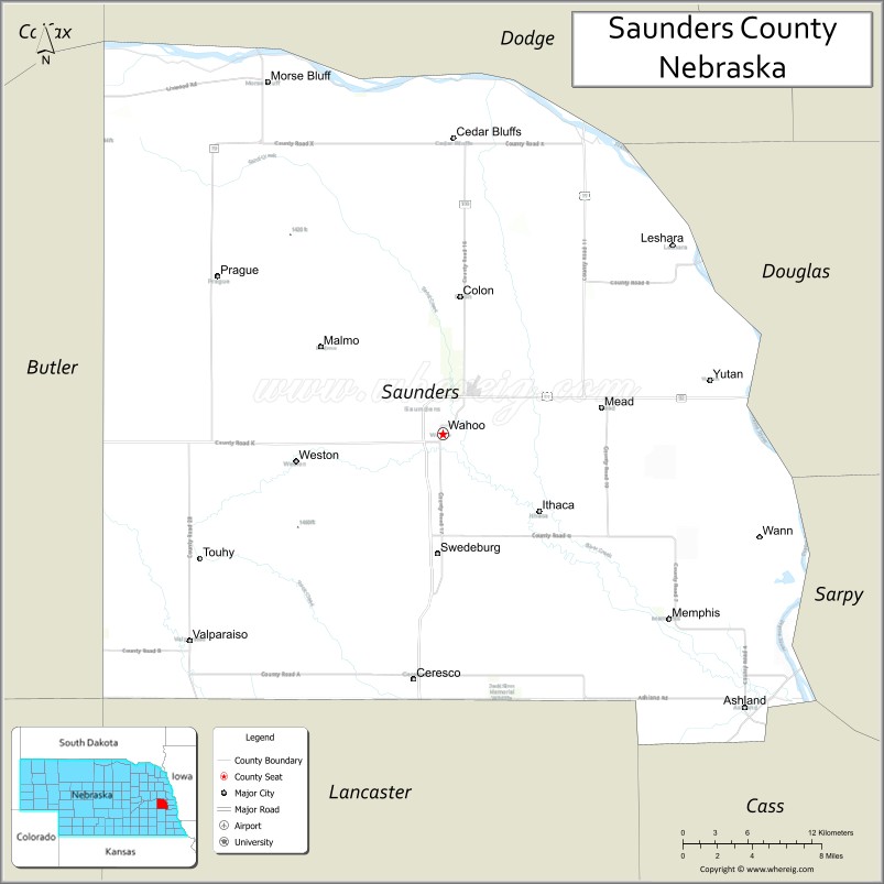
About Saunders County Map, Nebraska: The map showing the county boundary, county seat, major cities, highways, water bodies and neighbouring counties.
Related Nebraska Maps & Info
Map of Saunders County, Nebraska
Saunders County is a county located in the U.S. state of Nebraska. It's county seat is Wahoo. As per 2020 census, the population of Saunders County is 22787 people and population density is square miles. According to the United States Census Bureau, the county has a total area of 754 sq mi (1,953 km2). Saunders County was established on 1856.
Saunders County Facts
| Continent | North America |
| Country | United States |
| State | Nebraska |
| County Seat | Wahoo |
| Largest City/Town | Wahoo |
| Established | 1856 |
| Total Area | 760 sq mi (1,968 sq km) |
| Land Area | 750 sq mi (1,942 sq km) |
| Water Area | 10 sq mi (26 sq km) |
| Population | 22,278 (Census 2020) |
| Population Density | 29.7 people per sq mi |
| Time Zone | Central Time Zone |
| Major Highways | U.S. Route 77, Nebraska Highway 92, Nebraska Highway 79 |
| Major Rivers | Platte River, Elkhorn River |
| Neighboring Counties | Dodge County, Douglas County, Sarpy County, Cass County, Lancaster County, Butler County |
| Famous For | Mahoney State Park nearby region, agriculture, and scenic river valleys |
| Top Attractions | Eugene T. Mahoney State Park nearby region, Saunders County Historical Society Museum, and Platte River recreation areas |
| Official Website | Official Website |
About Saunders County, Nebraska
Saunders County is located in eastern Nebraska in the United States and was established in 1856. The county seat is Wahoo, which is also the largest city in the county. The county is known for agriculture, scenic river valleys, outdoor recreation areas, and its proximity to both Omaha and Lincoln.
Cities and Towns in Saunders County, Nebraska
| City/Town | Population (Census 2020) | Latitude & Longitude |
|---|---|---|
| Wahoo (county seat) | 4,818 | 41.2111°N, 96.6203°W |
| Ashland | 3,262 | 41.0394°N, 96.3681°W |
| Cedar Bluffs | 615 | 41.3958°N, 96.6109°W |
| Ceresco | 889 | 41.0586°N, 96.6408°W |
| Colon | 109 | 41.2942°N, 96.6067°W |
| Ithaca | 137 | 41.1306°N, 96.5289°W |
| Malmo | 102 | 41.2667°N, 96.7297°W |
| Mead | 569 | 41.2339°N, 96.4864°W |
| Memphis | 109 | 41.0947°N, 96.4381°W |
| Morse Bluff | 117 | 41.4253°N, 96.7842°W |
| Prague | 291 | 41.3081°N, 96.8133°W |
| Valparaiso | 595 | 41.0719°N, 96.8320°W |
| Weston | 235 | 41.2006°N, 96.7792°W |
| Yutan | 1,174 | 41.2436°N, 96.3970°W |
Golf Courses in Saunders County, Nebraska
| Golf Course | Location | Latitude & Longitude |
|---|---|---|
| Hilltop Country Club | Wahoo | 41.2150°N, 96.6265°W |
| Ashland Golf Club | Ashland | 41.0436°N, 96.3734°W |
| Quarry Oaks Golf Club | Ashland nearby region | 41.0331°N, 96.3358°W |
Roads and Highways in Saunders County, Nebraska
Major highways connect the county to Omaha, Lincoln, and nearby regional destinations.
- U.S. Route 77 - north-south highway connecting Wahoo with Lincoln and Fremont
- Nebraska Highway 92 - east-west route serving communities across eastern Nebraska
- Nebraska Highway 79 - regional highway linking agricultural and suburban communities
Neighboring Counties of Saunders County
- Dodge County (north)
- Douglas County (northeast)
- Sarpy County (east)
- Cass County (southeast)
- Lancaster County (south)
- Butler County (west)
What Are the Top Attractions in Saunders County, Nebraska
The county offers a mix of natural, historical, and recreational attractions.
- Eugene T. Mahoney State Park Nearby Region - popular destination for camping, hiking, fishing, cabins, and family recreation
- Saunders County Historical Society Museum - exhibits highlighting pioneer history and local heritage
- Platte River Recreation Areas - scenic locations ideal for wildlife viewing, fishing, and outdoor activities
- Wahoo Downtown District - local shops, restaurants, and historic architecture
- Ashland Community Attractions - parks, recreation areas, and family entertainment venues
- Lee G. Simmons Conservation Park and Wildlife Safari Nearby Region - wildlife attraction featuring North American animals
- Yutan Prairie Landscapes - scenic countryside featuring rolling farmland and open views
- Saunders County Fairgrounds - venue for fairs, rodeos, livestock events, and festivals
- Outdoor Recreation Trails - biking, hiking, camping, and birdwatching opportunities
- Scenic River Valley Drives - countryside routes with Platte and Elkhorn River views
What Is the Distance from Saunders County to Nearby Cities
The following distances are measured by road (driving).
- Wahoo to Lincoln (Lancaster County), Nebraska - 32 mi (51 km)
- Wahoo to Omaha (Douglas County), Nebraska - 38 mi (61 km)
- Wahoo to Fremont (Dodge County), Nebraska - 24 mi (39 km)
- Wahoo to Columbus (Platte County), Nebraska - 53 mi (85 km)
- Wahoo to Grand Island (Hall County), Nebraska - 112 mi (180 km)
- Wahoo to Kearney (Buffalo County), Nebraska - 150 mi (241 km)
- Wahoo to Sioux City, Iowa - 116 mi (187 km)
- Wahoo to Des Moines, Iowa - 176 mi (283 km)
- Wahoo to Kansas City, Missouri - 220 mi (354 km)
- Wahoo to North Platte (Lincoln County), Nebraska - 245 mi (394 km)
- Wahoo to Denver, Colorado - 500 mi (805 km)
- Wahoo to Sioux Falls, South Dakota - 197 mi (317 km)
FAQs about Saunders County
Saunders County is located in eastern Nebraska in the United States.
Saunders County had a population of 22,278 according to Census 2020 data.
Saunders County is known for Mahoney State Park nearby recreation, agriculture, and scenic river valleys.
The county is served by U.S. Route 77, Nebraska Highway 92, and Nebraska Highway 79.
Yes, Saunders County has golf facilities including Hilltop Country Club and Ashland Golf Club.
References
- QuickFacts - U.S. Census Bureau
- United States Census Bureau
- United States Geological Survey (USGS)
- National Geodetic Survey
- Official County Website
- Adams County Map
- Antelope County Map
- Arthur County Map
- Banner County Map
- Blaine County Map
- Boone County Map
- Box Butte County Map
- Boyd County Map
- Brown County Map
- Buffalo County Map
- Burt County Map
- Butler County Map
- Cass County Map
- Cedar County Map
- Chase County Map
- Cherry County Map
- Cheyenne County Map
- Clay County Map
- Colfax County Map
- Cuming County Map
- Custer County Map
- Dakota County Map
- Dawes County Map
- Dawson County Map
- Deuel County Map
- Dixon County Map
- Dodge County Map
- Douglas County Map
- Dundy County Map
- Fillmore County Map
- Franklin County Map
- Frontier County Map
- Furnas County Map
- Gage County Map
- Garden County Map
- Garfield County Map
- Gosper County Map
- Grant County Map
- Greeley County Map
- Hall County Map
- Hamilton County Map
- Harlan County Map
- Hayes County Map
- Hitchcock County Map
- Holt County Map
- Hooker County Map
- Howard County Map
- Jefferson County Map
- Johnson County Map
- Kearney County Map
- Keith County Map
- Keya Paha County Map
- Kimball County Map
- Knox County Map
- Lancaster County Map
- Lincoln County Map
- Logan County Map
- Loup County Map
- McPherson County Map
- Madison County Map
- Merrick County Map
- Morrill County Map
- Nance County Map
- Nemaha County Map
- Nuckolls County Map
- Otoe County Map
- Pawnee County Map
- Perkins County Map
- Phelps County Map
- Pierce County Map
- Platte County Map
- Polk County Map
- Red Willow County Map
- Richardson County Map
- Rock County Map
- Saline County Map
- Sarpy County Map
- Saunders County Map
- Scotts Bluff County Map
- Seward County Map
- Sheridan County Map
- Sherman County Map
- Sioux County Map
- Stanton County Map
- Thayer County Map
- Thomas County Map
- Thurston County Map
- Valley County Map
- Washington County Map
- Wayne County Map
- Webster County Map
- Wheeler County Map
- York County Map
- Alabama Counties
- Alaska boroughs
- Arizona Counties
- Arkansas Counties
- California County Map
- Colorado Counties
- Connecticut Counties
- Delaware Counties
- Florida County Map
- Georgia County Map
- Hawaii Counties
- Idaho Counties
- Illinois Counties
- Indiana Counties
- Iowa Counties
- Kansas Counties
- Kentucky Counties
- Louisiana Counties
- Maine Counties
- Maryland Counties
- Massachusetts Counties
- Michigan County Map
- Minnesota Counties
- Mississippi Counties
- Missouri Counties
- Montana Counties
- Nebraska Counties
- Nevada Counties
- New York Counties
- New Hampshire Counties
- New Jersey Counties
- New Mexico Counties
- North Carolina Counties
- North Dakota Counties
- Ohio County Map
- Oklahoma Counties
- Oregon Counties
- Pennsylvania Counties
- Rhode Island Counties
- South Carolina Counties
- South Dakota Counties
- Map of Tennessee
- Texas County Map
- Utah Counties
- Vermont Counties
- Virginia Counties
- Washington Counties
- West Virginia Counties
- Wisconsin Counties
- Wyoming Counties