Written and Fact-checked by Whereig Editors, Reviewed by Mukesh Kumar| Last Updated On: May 10, 2026
Map of Kimball County - Kimball County is a county located in the U.S. state of Nebraska. Kimball County Map showing cities, highways, important places and water bodies. Get Where is Kimball County located in the map, major cities in Kimball county, population, areas, and places of interest.
Map of Kimball County, Nebraska
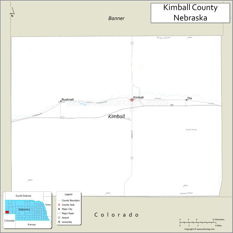
About Kimball County Map, Nebraska: The map showing the county boundary, county seat, major cities, highways, water bodies and neighbouring counties.
Related Nebraska Maps & Info
Map of Kimball County, Nebraska
Kimball County is a county located in the U.S. state of Nebraska. It's county seat is Kimball. As per 2020 census, the population of Kimball County is 3412 people and population density is square miles. According to the United States Census Bureau, the county has a total area of 952 sq mi (2,466 km2). Kimball County was established on 1888.
Kimball County Facts
| Continent | North America |
| Country | United States |
| State | Nebraska |
| County Seat | Kimball |
| Largest City/Town | Kimball |
| Established | 1888 |
| Total Area | 952 sq mi (2,466 sq km) |
| Land Area | 952 sq mi (2,466 sq km) |
| Water Area | 0.2 sq mi (0.5 sq km) |
| Population | 3,707 (Census 2020) |
| Population Density | 3.9 people per sq mi |
| Time Zone | Mountain Time Zone |
| Major Highways | Interstate 80, U.S. Route 30, Nebraska Highway 71 |
| Major Rivers | Lodgepole Creek |
| Neighboring Counties | Cheyenne County, Banner County, Morrill County, Laramie County (Wyoming) |
| Famous For | High Plains scenery, Interstate 80 travel corridor, and western Nebraska ranching |
| Top Attractions | Oliver Reservoir Recreation Area, High Point Welcome Center, and Panorama Point region |
| Official Website | Official Website |
About Kimball County, Nebraska
Kimball County is located in the far western part of Nebraska along the Wyoming border and was established in 1888. The county seat is Kimball, which is also the largest city in the county. The county is known for its ranching heritage, open High Plains landscapes, scenic interstate travel routes, and outdoor recreation opportunities.
Cities and Towns in Kimball County, Nebraska
| City/Town | Population (Census 2020) | Latitude & Longitude |
|---|---|---|
| Kimball (county seat) | 2,290 | 41.2358°N, 103.6630°W |
| Bushnell | 124 | 41.2292°N, 103.8892°W |
| Dix | 187 | 41.2350°N, 103.4956°W |
Golf Courses in Kimball County, Nebraska
| Golf Course | Location | Latitude & Longitude |
|---|---|---|
| Four Winds Golf Course | Kimball | 41.2394°N, 103.6692°W |
Roads and Highways in Kimball County, Nebraska
Major highways connect the county to nearby regions and states.
- Interstate 80 - major east-west interstate connecting Kimball County with Cheyenne and Sidney
- U.S. Route 30 - historic highway running parallel to Interstate 80 through western Nebraska
- Nebraska Highway 71 - north-south route linking Kimball County with Scottsbluff and Colorado
Neighboring Counties of Kimball County
- Banner County (north)
- Cheyenne County (east)
- Morrill County (northeast)
- Laramie County, Wyoming (west)
What Are the Top Attractions in Kimball County, Nebraska
The county offers a mix of natural and cultural attractions.
- Oliver Reservoir Recreation Area - recreation destination known for boating, fishing, camping, and swimming
- High Point Welcome Center - scenic travel stop featuring Nebraska history and panoramic prairie views
- Panorama Point Region - area near Nebraska’s highest natural point with expansive High Plains scenery
- Kimball Downtown Area - local shops, restaurants, and historic western Nebraska buildings
- Four Winds Golf Course - community golf course with open prairie landscapes
- Lodgepole Creek Scenic Areas - natural habitats supporting birds and prairie wildlife
- Dix Prairie Landscapes - countryside scenery ideal for photography and scenic drives
- Bushnell Historic Sites - small-town landmarks reflecting railroad and ranching history
- Western Nebraska Scenic Drives - open-road routes featuring High Plains grasslands and ranches
- Kimball County Historical Museum - exhibits highlighting pioneer settlement and regional history
What Is the Distance from Kimball County to Nearby Cities
The following distances are measured by road (driving).
- Kimball to Sidney (Cheyenne County), Nebraska - 43 mi (69 km)
- Kimball to Scottsbluff (Scotts Bluff County), Nebraska - 64 mi (103 km)
- Kimball to Ogallala (Keith County), Nebraska - 98 mi (158 km)
- Kimball to Cheyenne, Wyoming - 45 mi (72 km)
- Kimball to Laramie, Wyoming - 92 mi (148 km)
- Kimball to Denver, Colorado - 170 mi (274 km)
- Kimball to North Platte (Lincoln County), Nebraska - 153 mi (246 km)
- Kimball to Alliance (Box Butte County), Nebraska - 112 mi (180 km)
- Kimball to Kearney (Buffalo County), Nebraska - 261 mi (420 km)
- Kimball to Grand Island (Hall County), Nebraska - 316 mi (509 km)
- Kimball to Lincoln (Lancaster County), Nebraska - 375 mi (604 km)
- Kimball to Omaha (Douglas County), Nebraska - 435 mi (700 km)
FAQs about Kimball County
Kimball County is located in far western Nebraska along the Wyoming border.
Kimball County had a population of 3,707 according to Census 2020 data.
Kimball County is known for High Plains scenery, ranching, and Interstate 80 travel routes.
The county is served by Interstate 80, U.S. Route 30, and Nebraska Highway 71.
Yes, Kimball County has the Four Winds Golf Course located near Kimball.
References
- QuickFacts - U.S. Census Bureau
- United States Census Bureau
- United States Geological Survey (USGS)
- National Geodetic Survey
- Official County Website
- Adams County Map
- Antelope County Map
- Arthur County Map
- Banner County Map
- Blaine County Map
- Boone County Map
- Box Butte County Map
- Boyd County Map
- Brown County Map
- Buffalo County Map
- Burt County Map
- Butler County Map
- Cass County Map
- Cedar County Map
- Chase County Map
- Cherry County Map
- Cheyenne County Map
- Clay County Map
- Colfax County Map
- Cuming County Map
- Custer County Map
- Dakota County Map
- Dawes County Map
- Dawson County Map
- Deuel County Map
- Dixon County Map
- Dodge County Map
- Douglas County Map
- Dundy County Map
- Fillmore County Map
- Franklin County Map
- Frontier County Map
- Furnas County Map
- Gage County Map
- Garden County Map
- Garfield County Map
- Gosper County Map
- Grant County Map
- Greeley County Map
- Hall County Map
- Hamilton County Map
- Harlan County Map
- Hayes County Map
- Hitchcock County Map
- Holt County Map
- Hooker County Map
- Howard County Map
- Jefferson County Map
- Johnson County Map
- Kearney County Map
- Keith County Map
- Keya Paha County Map
- Kimball County Map
- Knox County Map
- Lancaster County Map
- Lincoln County Map
- Logan County Map
- Loup County Map
- McPherson County Map
- Madison County Map
- Merrick County Map
- Morrill County Map
- Nance County Map
- Nemaha County Map
- Nuckolls County Map
- Otoe County Map
- Pawnee County Map
- Perkins County Map
- Phelps County Map
- Pierce County Map
- Platte County Map
- Polk County Map
- Red Willow County Map
- Richardson County Map
- Rock County Map
- Saline County Map
- Sarpy County Map
- Saunders County Map
- Scotts Bluff County Map
- Seward County Map
- Sheridan County Map
- Sherman County Map
- Sioux County Map
- Stanton County Map
- Thayer County Map
- Thomas County Map
- Thurston County Map
- Valley County Map
- Washington County Map
- Wayne County Map
- Webster County Map
- Wheeler County Map
- York County Map
- Alabama Counties
- Alaska boroughs
- Arizona Counties
- Arkansas Counties
- California County Map
- Colorado Counties
- Connecticut Counties
- Delaware Counties
- Florida County Map
- Georgia County Map
- Hawaii Counties
- Idaho Counties
- Illinois Counties
- Indiana Counties
- Iowa Counties
- Kansas Counties
- Kentucky Counties
- Louisiana Counties
- Maine Counties
- Maryland Counties
- Massachusetts Counties
- Michigan County Map
- Minnesota Counties
- Mississippi Counties
- Missouri Counties
- Montana Counties
- Nebraska Counties
- Nevada Counties
- New York Counties
- New Hampshire Counties
- New Jersey Counties
- New Mexico Counties
- North Carolina Counties
- North Dakota Counties
- Ohio County Map
- Oklahoma Counties
- Oregon Counties
- Pennsylvania Counties
- Rhode Island Counties
- South Carolina Counties
- South Dakota Counties
- Map of Tennessee
- Texas County Map
- Utah Counties
- Vermont Counties
- Virginia Counties
- Washington Counties
- West Virginia Counties
- Wisconsin Counties
- Wyoming Counties