Written and Fact-checked by Whereig Editors, Reviewed by Mukesh Kumar| Last Updated On: May 10, 2026
Map of Howard County - Howard County is a county located in the U.S. state of Nebraska. Howard County Map showing cities, highways, important places and water bodies. Get Where is Howard County located in the map, major cities in Howard county, population, areas, and places of interest.
Map of Howard County, Nebraska
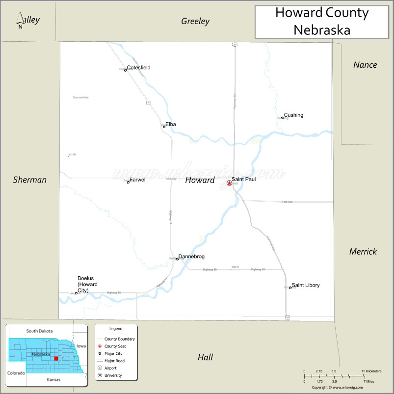
About Howard County Map, Nebraska: The map showing the county boundary, county seat, major cities, highways, water bodies and neighbouring counties.
Related Nebraska Maps & Info
Map of Howard County, Nebraska
Howard County is a county located in the U.S. state of Nebraska. It's county seat is Saint Paul. As per 2020 census, the population of Howard County is 6531 people and population density is square miles. According to the United States Census Bureau, the county has a total area of 570 sq mi (1,476 km2). Howard County was established on 1871.
Howard County Facts
| Continent | North America |
| Country | United States |
| State | Nebraska |
| County Seat | St. Paul |
| Largest City/Town | St. Paul |
| Established | 1871 |
| Total Area | 576 sq mi (1,492 sq km) |
| Land Area | 570 sq mi (1,476 sq km) |
| Water Area | 6 sq mi (16 sq km) |
| Population | 6,182 (Census 2020) |
| Population Density | 10.8 people per sq mi |
| Time Zone | Central Time Zone |
| Major Highways | U.S. Route 281, Nebraska Highway 92, Nebraska Highway 11 |
| Major Rivers | North Loup River |
| Neighboring Counties | Greeley County, Merrick County, Hall County, Sherman County, Valley County |
| Famous For | Agriculture, North Loup River Valley, and the city of St. Paul |
| Top Attractions | Sherman Reservoir area, North Loup River, and Howard County Historical Village |
| Official Website | Official Website |
About Howard County, Nebraska
Howard County is located in central Nebraska in the United States and was established in 1871. The county seat is St. Paul, which is also the largest city in the county. The county is known for its farming economy, scenic river valleys, and outdoor recreation areas that support fishing, boating, and wildlife viewing.
Cities and Towns in Howard County, Nebraska
| City/Town | Population (Census 2020) | Latitude & Longitude |
|---|---|---|
| St. Paul (county seat) | 2,290 | 41.2147°N, 98.4584°W |
| Boelus | 189 | 41.0911°N, 98.7609°W |
| Cushing | 32 | 41.2569°N, 98.2670°W |
| Dannebrog | 273 | 41.1181°N, 98.5467°W |
| Elba | 215 | 41.2831°N, 98.5714°W |
| Farwell | 122 | 41.2145°N, 98.6312°W |
| St. Libory | 60 | 41.0892°N, 98.3623°W |
Golf Courses in Howard County, Nebraska
| Golf Course | Location | Latitude & Longitude |
|---|---|---|
| St. Paul Country Club | St. Paul | 41.2168°N, 98.4549°W |
| Centura Hills Golf Club | Dannebrog | 41.1172°N, 98.5430°W |
Roads and Highways in Howard County, Nebraska
Major highways connect the county to nearby regions and cities.
- U.S. Route 281 - north-south highway connecting St. Paul with Grand Island and O'Neill
- Nebraska Highway 92 - east-west route serving central Nebraska communities and recreation areas
- Nebraska Highway 11 - regional highway linking Howard County with Burwell and surrounding counties
Neighboring Counties of Howard County
- Valley County (northwest)
- Greeley County (north)
- Merrick County (east)
- Hall County (south)
- Sherman County (west)
What Are the Top Attractions in Howard County, Nebraska
The county offers a mix of natural and cultural attractions.
- Sherman Reservoir Recreation Area - popular destination for boating, fishing, camping, and swimming
- North Loup River - scenic river known for fishing, canoeing, and wildlife viewing
- Howard County Historical Village - historic buildings and exhibits showcasing pioneer life
- St. Paul Downtown District - local shops, restaurants, and community events
- Dannebrog Danish Heritage Area - community celebrating Danish cultural traditions and history
- Boelus Prairie Scenic Drives - countryside routes with Nebraska farmland views
- Elba Community Park - recreation area with playgrounds and picnic facilities
- Farwell Wildlife Areas - habitats supporting migratory birds and prairie wildlife
- St. Libory Community Grounds - local gathering and recreation area
- Rural River Valley Landscapes - scenic views of the North Loup River Valley and surrounding farmland
What Is the Distance from Howard County to Nearby Cities
The following distances are measured by road (driving).
- St. Paul to Grand Island (Hall County), Nebraska - 25 mi (40 km)
- St. Paul to Kearney (Buffalo County), Nebraska - 47 mi (76 km)
- St. Paul to Hastings (Adams County), Nebraska - 53 mi (85 km)
- St. Paul to Ord (Valley County), Nebraska - 41 mi (66 km)
- St. Paul to Broken Bow (Custer County), Nebraska - 67 mi (108 km)
- St. Paul to Columbus (Platte County), Nebraska - 71 mi (114 km)
- St. Paul to York (York County), Nebraska - 63 mi (101 km)
- St. Paul to Norfolk (Madison County), Nebraska - 109 mi (175 km)
- St. Paul to North Platte (Lincoln County), Nebraska - 137 mi (220 km)
- St. Paul to Lincoln (Lancaster County), Nebraska - 114 mi (183 km)
- St. Paul to Omaha (Douglas County), Nebraska - 173 mi (278 km)
- St. Paul to Denver, Colorado - 398 mi (640 km)
FAQs about Howard County
Howard County is located in central Nebraska in the United States.
Howard County had a population of 6,182 according to Census 2020 data.
Howard County is known for agriculture, river valley scenery, and outdoor recreation areas.
The county is served by U.S. Route 281, Nebraska Highway 92, and Nebraska Highway 11.
Yes, Howard County has golf facilities including St. Paul Country Club and Centura Hills Golf Club.
References
- QuickFacts - U.S. Census Bureau
- United States Census Bureau
- United States Geological Survey (USGS)
- National Geodetic Survey
- Official County Website
- Adams County Map
- Antelope County Map
- Arthur County Map
- Banner County Map
- Blaine County Map
- Boone County Map
- Box Butte County Map
- Boyd County Map
- Brown County Map
- Buffalo County Map
- Burt County Map
- Butler County Map
- Cass County Map
- Cedar County Map
- Chase County Map
- Cherry County Map
- Cheyenne County Map
- Clay County Map
- Colfax County Map
- Cuming County Map
- Custer County Map
- Dakota County Map
- Dawes County Map
- Dawson County Map
- Deuel County Map
- Dixon County Map
- Dodge County Map
- Douglas County Map
- Dundy County Map
- Fillmore County Map
- Franklin County Map
- Frontier County Map
- Furnas County Map
- Gage County Map
- Garden County Map
- Garfield County Map
- Gosper County Map
- Grant County Map
- Greeley County Map
- Hall County Map
- Hamilton County Map
- Harlan County Map
- Hayes County Map
- Hitchcock County Map
- Holt County Map
- Hooker County Map
- Howard County Map
- Jefferson County Map
- Johnson County Map
- Kearney County Map
- Keith County Map
- Keya Paha County Map
- Kimball County Map
- Knox County Map
- Lancaster County Map
- Lincoln County Map
- Logan County Map
- Loup County Map
- McPherson County Map
- Madison County Map
- Merrick County Map
- Morrill County Map
- Nance County Map
- Nemaha County Map
- Nuckolls County Map
- Otoe County Map
- Pawnee County Map
- Perkins County Map
- Phelps County Map
- Pierce County Map
- Platte County Map
- Polk County Map
- Red Willow County Map
- Richardson County Map
- Rock County Map
- Saline County Map
- Sarpy County Map
- Saunders County Map
- Scotts Bluff County Map
- Seward County Map
- Sheridan County Map
- Sherman County Map
- Sioux County Map
- Stanton County Map
- Thayer County Map
- Thomas County Map
- Thurston County Map
- Valley County Map
- Washington County Map
- Wayne County Map
- Webster County Map
- Wheeler County Map
- York County Map
- Alabama Counties
- Alaska boroughs
- Arizona Counties
- Arkansas Counties
- California County Map
- Colorado Counties
- Connecticut Counties
- Delaware Counties
- Florida County Map
- Georgia County Map
- Hawaii Counties
- Idaho Counties
- Illinois Counties
- Indiana Counties
- Iowa Counties
- Kansas Counties
- Kentucky Counties
- Louisiana Counties
- Maine Counties
- Maryland Counties
- Massachusetts Counties
- Michigan County Map
- Minnesota Counties
- Mississippi Counties
- Missouri Counties
- Montana Counties
- Nebraska Counties
- Nevada Counties
- New York Counties
- New Hampshire Counties
- New Jersey Counties
- New Mexico Counties
- North Carolina Counties
- North Dakota Counties
- Ohio County Map
- Oklahoma Counties
- Oregon Counties
- Pennsylvania Counties
- Rhode Island Counties
- South Carolina Counties
- South Dakota Counties
- Map of Tennessee
- Texas County Map
- Utah Counties
- Vermont Counties
- Virginia Counties
- Washington Counties
- West Virginia Counties
- Wisconsin Counties
- Wyoming Counties