Written and Fact-checked by Whereig Editors, Reviewed by Mukesh Kumar| Last Updated On: May 10, 2026
Map of Keya Paha County - Keya Paha County is a county located in the U.S. state of Nebraska. Keya Paha County Map showing cities, highways, important places and water bodies. Get Where is Keya Paha County located in the map, major cities in Keya Paha county, population, areas, and places of interest.
Map of Keya Paha County, Nebraska
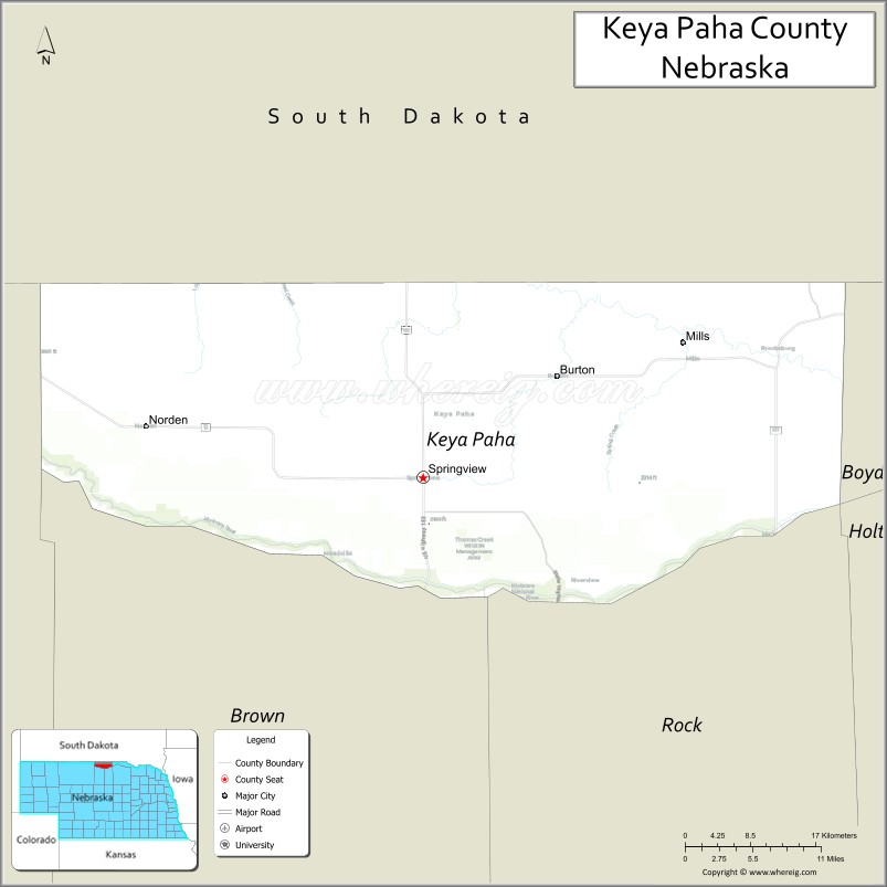
About Keya Paha County Map, Nebraska: The map showing the county boundary, county seat, major cities, highways, water bodies and neighbouring counties.
Related Nebraska Maps & Info
Map of Keya Paha County, Nebraska
Keya Paha County is a county located in the U.S. state of Nebraska. It's county seat is Springview. As per 2020 census, the population of Keya Paha County is 787 people and population density is square miles. According to the United States Census Bureau, the county has a total area of 773 sq mi (2,002 km2). Keya Paha County was established on 1884.
Keya Paha County Facts
| Continent | North America |
| Country | United States |
| State | Nebraska |
| County Seat | Springview |
| Largest City/Town | Springview |
| Established | 1884 |
| Total Area | 774 sq mi (2,005 sq km) |
| Land Area | 773 sq mi (2,002 sq km) |
| Water Area | 1 sq mi (2.6 sq km) |
| Population | 824 (Census 2020) |
| Population Density | 1.1 people per sq mi |
| Time Zone | Central Time Zone |
| Major Highways | Nebraska Highway 7, Nebraska Highway 12 |
| Major Rivers | Niobrara River, Keya Paha River |
| Neighboring Counties | Boyd County, Brown County, Cherry County, Tripp County (South Dakota) |
| Famous For | Niobrara River scenery, Sandhills ranching, and remote prairie landscapes |
| Top Attractions | Niobrara National Scenic River, Keller Park State Recreation Area, and Keya Paha River Valley |
| Official Website | Official Website |
About Keya Paha County, Nebraska
Keya Paha County is located in north-central Nebraska along the South Dakota border and was established in 1884. The county seat is Springview, which is also the largest community in the county. The county is known for its rugged prairie landscapes, cattle ranching, scenic river valleys, and quiet Sandhills environments that support outdoor recreation and wildlife viewing.
Cities and Towns in Keya Paha County, Nebraska
| City/Town | Population (Census 2020) | Latitude & Longitude |
|---|---|---|
| Springview (county seat) | 242 | 42.8244°N, 99.7490°W |
| Burton | 9 | 42.8886°N, 99.1298°W |
| Mills | 11 | 42.8583°N, 99.4451°W |
Golf Courses in Keya Paha County, Nebraska
| Golf Course | Location | Latitude & Longitude |
|---|---|---|
| Springview Golf Course | Springview | 42.8262°N, 99.7448°W |
Roads and Highways in Keya Paha County, Nebraska
Major highways connect the county to nearby regions and communities.
- Nebraska Highway 7 - north-south highway linking Springview with Ainsworth and South Dakota
- Nebraska Highway 12 - scenic route crossing northern Nebraska along the Niobrara River region
Neighboring Counties of Keya Paha County
- Boyd County (east)
- Brown County (south)
- Cherry County (west)
- Tripp County, South Dakota (north)
What Are the Top Attractions in Keya Paha County, Nebraska
The county offers a mix of natural and cultural attractions.
- Niobrara National Scenic River - scenic river corridor known for canoeing, kayaking, fishing, and wildlife viewing
- Keller Park State Recreation Area - outdoor recreation area with camping, boating, and fishing opportunities
- Keya Paha River Valley - picturesque prairie river valley with rolling Sandhills scenery
- Springview Community Park - local recreation area with picnic facilities and sports grounds
- Sandhills Scenic Drives - countryside routes featuring Nebraska prairie and dune landscapes
- Wildlife Habitat Areas - natural prairie environments supporting deer, pheasants, and migratory birds
- Burton Prairie Landscapes - remote countryside ideal for photography and sightseeing
- Mills Rural Heritage Areas - ranchland scenery reflecting traditional Nebraska cattle culture
- Niobrara River Overlooks - scenic viewpoints offering river valley panoramas
- Keya Paha Historical Displays - local exhibits highlighting pioneer settlement and ranching history
What Is the Distance from Keya Paha County to Nearby Cities
The following distances are measured by road (driving).
- Springview to Ainsworth (Brown County), Nebraska - 39 mi (63 km)
- Springview to Valentine (Cherry County), Nebraska - 81 mi (130 km)
- Springview to O'Neill (Holt County), Nebraska - 79 mi (127 km)
- Springview to Winner, South Dakota - 56 mi (90 km)
- Springview to Norfolk (Madison County), Nebraska - 162 mi (261 km)
- Springview to Broken Bow (Custer County), Nebraska - 148 mi (238 km)
- Springview to Grand Island (Hall County), Nebraska - 225 mi (362 km)
- Springview to Kearney (Buffalo County), Nebraska - 244 mi (393 km)
- Springview to North Platte (Lincoln County), Nebraska - 220 mi (354 km)
- Springview to Lincoln (Lancaster County), Nebraska - 288 mi (463 km)
- Springview to Omaha (Douglas County), Nebraska - 276 mi (444 km)
- Springview to Sioux Falls, South Dakota - 204 mi (328 km)
FAQs about Keya Paha County
Keya Paha County is located in north-central Nebraska along the South Dakota border.
Keya Paha County had a population of 824 according to Census 2020 data.
Keya Paha County is known for Sandhills ranching, river scenery, and outdoor recreation.
The county is served by Nebraska Highway 7 and Nebraska Highway 12.
Yes, Keya Paha County has the Springview Golf Course located near Springview.
References
- QuickFacts - U.S. Census Bureau
- United States Census Bureau
- United States Geological Survey (USGS)
- National Geodetic Survey
- Official County Website
- Adams County Map
- Antelope County Map
- Arthur County Map
- Banner County Map
- Blaine County Map
- Boone County Map
- Box Butte County Map
- Boyd County Map
- Brown County Map
- Buffalo County Map
- Burt County Map
- Butler County Map
- Cass County Map
- Cedar County Map
- Chase County Map
- Cherry County Map
- Cheyenne County Map
- Clay County Map
- Colfax County Map
- Cuming County Map
- Custer County Map
- Dakota County Map
- Dawes County Map
- Dawson County Map
- Deuel County Map
- Dixon County Map
- Dodge County Map
- Douglas County Map
- Dundy County Map
- Fillmore County Map
- Franklin County Map
- Frontier County Map
- Furnas County Map
- Gage County Map
- Garden County Map
- Garfield County Map
- Gosper County Map
- Grant County Map
- Greeley County Map
- Hall County Map
- Hamilton County Map
- Harlan County Map
- Hayes County Map
- Hitchcock County Map
- Holt County Map
- Hooker County Map
- Howard County Map
- Jefferson County Map
- Johnson County Map
- Kearney County Map
- Keith County Map
- Keya Paha County Map
- Kimball County Map
- Knox County Map
- Lancaster County Map
- Lincoln County Map
- Logan County Map
- Loup County Map
- McPherson County Map
- Madison County Map
- Merrick County Map
- Morrill County Map
- Nance County Map
- Nemaha County Map
- Nuckolls County Map
- Otoe County Map
- Pawnee County Map
- Perkins County Map
- Phelps County Map
- Pierce County Map
- Platte County Map
- Polk County Map
- Red Willow County Map
- Richardson County Map
- Rock County Map
- Saline County Map
- Sarpy County Map
- Saunders County Map
- Scotts Bluff County Map
- Seward County Map
- Sheridan County Map
- Sherman County Map
- Sioux County Map
- Stanton County Map
- Thayer County Map
- Thomas County Map
- Thurston County Map
- Valley County Map
- Washington County Map
- Wayne County Map
- Webster County Map
- Wheeler County Map
- York County Map
- Alabama Counties
- Alaska boroughs
- Arizona Counties
- Arkansas Counties
- California County Map
- Colorado Counties
- Connecticut Counties
- Delaware Counties
- Florida County Map
- Georgia County Map
- Hawaii Counties
- Idaho Counties
- Illinois Counties
- Indiana Counties
- Iowa Counties
- Kansas Counties
- Kentucky Counties
- Louisiana Counties
- Maine Counties
- Maryland Counties
- Massachusetts Counties
- Michigan County Map
- Minnesota Counties
- Mississippi Counties
- Missouri Counties
- Montana Counties
- Nebraska Counties
- Nevada Counties
- New York Counties
- New Hampshire Counties
- New Jersey Counties
- New Mexico Counties
- North Carolina Counties
- North Dakota Counties
- Ohio County Map
- Oklahoma Counties
- Oregon Counties
- Pennsylvania Counties
- Rhode Island Counties
- South Carolina Counties
- South Dakota Counties
- Map of Tennessee
- Texas County Map
- Utah Counties
- Vermont Counties
- Virginia Counties
- Washington Counties
- West Virginia Counties
- Wisconsin Counties
- Wyoming Counties