Written and Fact-checked by Whereig Editors, Reviewed by Mukesh Kumar| Last Updated On: May 10, 2026
Map of Dakota County - Dakota County is a county located in the U.S. state of Nebraska. Dakota County Map showing cities, highways, important places and water bodies. Get Where is Dakota County located in the map, major cities in Dakota county, population, areas, and places of interest.
Map of Dakota County, Nebraska
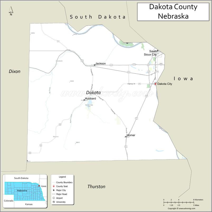
About Dakota County Map, Nebraska: The map showing the county boundary, county seat, major cities, highways, water bodies and neighbouring counties.
Related Nebraska Maps & Info
Map of Dakota County, Nebraska
Dakota County is a county located in the U.S. state of Nebraska. It's county seat is Dakota City. As per 2020 census, the population of Dakota County is 21241 people and population density is square miles. According to the United States Census Bureau, the county has a total area of 264 sq mi (684 km2). Dakota County was established on 1855.
Dakota County Facts
| Continent | North America |
| Country | United States |
| State | Nebraska |
| County Seat | Dakota City |
| Largest City/Town | South Sioux City |
| Established | 1855 |
| Total Area | 267 sq mi (692 sq km) |
| Land Area | 264 sq mi (684 sq km) |
| Water Area | 3 sq mi (8 sq km) |
| Population | 21,582 (Census 2020) |
| Population Density | 81.8 people per sq mi |
| Time Zone | Central Time Zone (CT) |
| Major Highways | Interstate 129, US 75, US 77, US 20 |
| Major Rivers | Missouri River, Big Sioux River |
| Neighboring Counties | Dixon County, Thurston County, Union County (SD), Woodbury County (IA), Plymouth County (IA) |
| Famous For | Missouri River Valley, South Sioux City, agriculture, transportation and industry |
| Top Attractions | Lewis and Clark Interpretive Center nearby, South Sioux City parks, Missouri River recreation, scenic riverfront areas |
| Official Website | Official Website |
About Dakota County, Nebraska
Dakota County is located in northeastern Nebraska in the United States and was established in 1855. The county seat is Dakota City, while the largest city is South Sioux City. The county is known for Missouri River Valley scenery, transportation and industrial activity, agriculture, and its close connection to the Sioux City metropolitan area.
Cities and Towns in Dakota County, Nebraska
| City/Town | Population (Census 2020) | Latitude & Longitude |
|---|---|---|
| South Sioux City | 13,916 | 42.4739°N, 96.4131°W |
| Dakota City (county seat) | 1,866 | 42.4169°N, 96.4189°W |
| Homer | 549 | 42.3244°N, 96.4881°W |
| Jackson | 188 | 42.4561°N, 96.5720°W |
| Emerson nearby | 735 | 42.2789°N, 96.7278°W |
| Hubbard | 236 | 42.3858°N, 96.5748°W |
Golf Courses in Dakota County, Nebraska
| Golf Course | Location | Latitude & Longitude |
|---|---|---|
| Covington Links Golf Course | South Sioux City | 42.4789°N, 96.4298°W |
| Dakota Dunes Country Club nearby | Dakota Dunes, South Dakota | 42.4931°N, 96.4886°W |
| Two Rivers Golf Club nearby | Dakota Dunes, South Dakota | 42.4900°N, 96.4789°W |
| Whispering Creek Golf Club nearby | Sioux City, Iowa | 42.4452°N, 96.4087°W |
Roads and Highways in Dakota County, Nebraska
Major highways connect the county to the Sioux City metropolitan area and regional transportation networks.
- Interstate 129 - interstate connection to Sioux City and regional routes
- US Highway 75 - major north-south highway through eastern Nebraska
- US Highway 77 - important transportation route across the Missouri River region
- US Highway 20 - major east-west corridor across northern Nebraska
Neighboring Counties of Dakota County
- Union County, South Dakota (north)
- Plymouth County, Iowa (east)
- Woodbury County, Iowa (southeast)
- Thurston County (west)
- Dixon County (southwest)
What Are the Top Attractions in Dakota County, Nebraska
The county offers a mix of riverfront recreation, metropolitan attractions, and prairie landscapes.
- Lewis and Clark Interpretive Center nearby - exhibits about the historic expedition and regional history
- South Sioux City parks and recreation areas - trails, sports facilities, and family attractions
- Missouri River recreation - boating, fishing, kayaking, and scenic outdoor experiences
- Covington Links Golf Course - golf and recreation destination
- Scenic riverfront areas - walking paths and views along the Missouri River Valley
- Historic downtown Dakota City - local heritage and community attractions
- Birdwatching and wildlife habitats - river ecosystems and migratory bird viewing
- Fishing and hunting opportunities - waterfowl, deer, turkey, and river fishing recreation
- Camping and RV parks nearby - family-friendly outdoor recreation destinations
- Photography and sunset viewing along the Missouri River - scenic Nebraska and Iowa landscapes
- Community festivals and cultural celebrations - reflecting local heritage and traditions
- Historic railroad and transportation attractions - showcasing regional industrial history
- Nearby Sioux City attractions - museums, shopping, entertainment, and sports venues
- Regional wineries and local dining destinations - food and cultural experiences
What Is the Distance from Dakota County to Nearby Cities
The following distances are measured by road (driving).
- Dakota City to Sioux City (Woodbury County), Iowa - 5 mi (8 km)
- Dakota City to Norfolk (Madison County), Nebraska - 72 mi (116 km)
- Dakota City to Sioux Falls (Minnehaha County), South Dakota - 88 mi (142 km)
- Dakota City to Omaha (Douglas County), Nebraska - 98 mi (158 km)
- Dakota City to Lincoln (Lancaster County), Nebraska - 154 mi (248 km)
- Dakota City to Des Moines (Polk County), Iowa - 198 mi (319 km)
- Dakota City to Grand Island (Hall County), Nebraska - 207 mi (333 km)
- Dakota City to Kansas City (Jackson County), Missouri - 296 mi (476 km)
- Dakota City to Pierre (Hughes County), South Dakota - 308 mi (496 km)
- Dakota City to North Platte (Lincoln County), Nebraska - 353 mi (568 km)
- Dakota City to Minneapolis (Hennepin County), Minnesota - 332 mi (534 km)
- Dakota City to Denver (Denver County), Colorado - 612 mi (985 km)
FAQs about Dakota County
Dakota County is located in northeastern Nebraska along the Missouri River near Iowa and South Dakota.
Dakota County had a population of 21,582 according to the 2020 United States Census.
Dakota County is known for Missouri River recreation, South Sioux City, transportation industries, and river valley scenery.
The major highways include Interstate 129, US Highway 75, US Highway 77, and US Highway 20.
Popular attractions include Missouri River recreation areas, South Sioux City parks, the Lewis and Clark Interpretive Center nearby, and scenic riverfront destinations.
References
- QuickFacts - U.S. Census Bureau
- United States Census Bureau
- United States Geological Survey (USGS)
- National Geodetic Survey
- Official Website
- Adams County Map
- Antelope County Map
- Arthur County Map
- Banner County Map
- Blaine County Map
- Boone County Map
- Box Butte County Map
- Boyd County Map
- Brown County Map
- Buffalo County Map
- Burt County Map
- Butler County Map
- Cass County Map
- Cedar County Map
- Chase County Map
- Cherry County Map
- Cheyenne County Map
- Clay County Map
- Colfax County Map
- Cuming County Map
- Custer County Map
- Dakota County Map
- Dawes County Map
- Dawson County Map
- Deuel County Map
- Dixon County Map
- Dodge County Map
- Douglas County Map
- Dundy County Map
- Fillmore County Map
- Franklin County Map
- Frontier County Map
- Furnas County Map
- Gage County Map
- Garden County Map
- Garfield County Map
- Gosper County Map
- Grant County Map
- Greeley County Map
- Hall County Map
- Hamilton County Map
- Harlan County Map
- Hayes County Map
- Hitchcock County Map
- Holt County Map
- Hooker County Map
- Howard County Map
- Jefferson County Map
- Johnson County Map
- Kearney County Map
- Keith County Map
- Keya Paha County Map
- Kimball County Map
- Knox County Map
- Lancaster County Map
- Lincoln County Map
- Logan County Map
- Loup County Map
- McPherson County Map
- Madison County Map
- Merrick County Map
- Morrill County Map
- Nance County Map
- Nemaha County Map
- Nuckolls County Map
- Otoe County Map
- Pawnee County Map
- Perkins County Map
- Phelps County Map
- Pierce County Map
- Platte County Map
- Polk County Map
- Red Willow County Map
- Richardson County Map
- Rock County Map
- Saline County Map
- Sarpy County Map
- Saunders County Map
- Scotts Bluff County Map
- Seward County Map
- Sheridan County Map
- Sherman County Map
- Sioux County Map
- Stanton County Map
- Thayer County Map
- Thomas County Map
- Thurston County Map
- Valley County Map
- Washington County Map
- Wayne County Map
- Webster County Map
- Wheeler County Map
- York County Map
- Alabama Counties
- Alaska boroughs
- Arizona Counties
- Arkansas Counties
- California County Map
- Colorado Counties
- Connecticut Counties
- Delaware Counties
- Florida County Map
- Georgia County Map
- Hawaii Counties
- Idaho Counties
- Illinois Counties
- Indiana Counties
- Iowa Counties
- Kansas Counties
- Kentucky Counties
- Louisiana Counties
- Maine Counties
- Maryland Counties
- Massachusetts Counties
- Michigan County Map
- Minnesota Counties
- Mississippi Counties
- Missouri Counties
- Montana Counties
- Nebraska Counties
- Nevada Counties
- New York Counties
- New Hampshire Counties
- New Jersey Counties
- New Mexico Counties
- North Carolina Counties
- North Dakota Counties
- Ohio County Map
- Oklahoma Counties
- Oregon Counties
- Pennsylvania Counties
- Rhode Island Counties
- South Carolina Counties
- South Dakota Counties
- Map of Tennessee
- Texas County Map
- Utah Counties
- Vermont Counties
- Virginia Counties
- Washington Counties
- West Virginia Counties
- Wisconsin Counties
- Wyoming Counties