Written and Fact-checked by Whereig Editors, Reviewed by Mukesh Kumar| Last Updated On: May 10, 2026
Map of Nemaha County - Nemaha County is a county located in the U.S. state of Nebraska. Nemaha County Map showing cities, highways, important places and water bodies. Get Where is Nemaha County located in the map, major cities in Nemaha county, population, areas, and places of interest.
Map of Nemaha County, Nebraska
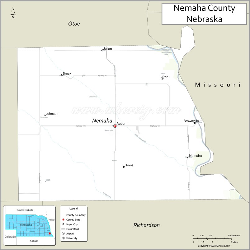
About Nemaha County Map, Nebraska: The map showing the county boundary, county seat, major cities, highways, water bodies and neighbouring counties.
Related Nebraska Maps & Info
Map of Nemaha County, Nebraska
Nemaha County is a county located in the U.S. state of Nebraska. It's county seat is Auburn. As per 2020 census, the population of Nemaha County is 7064 people and population density is square miles. According to the United States Census Bureau, the county has a total area of 409 sq mi (1,059 km2). Nemaha County was established on 1854.
Nemaha County Facts
| Continent | North America |
| Country | United States |
| State | Nebraska |
| County Seat | Auburn |
| Largest City/Town | Auburn |
| Established | 1855 |
| Total Area | 410 sq mi (1,062 sq km) |
| Land Area | 407 sq mi (1,054 sq km) |
| Water Area | 3 sq mi (7.8 sq km) |
| Population | 7,074 (Census 2020) |
| Population Density | 17.4 people per sq mi |
| Time Zone | Central Time Zone |
| Major Highways | U.S. Route 75, Nebraska Highway 4, Nebraska Highway 41 |
| Major Rivers | Missouri River, Nemaha River |
| Neighboring Counties | Otoe County, Johnson County, Richardson County, Atchison County (Missouri) |
| Famous For | Arbor Day Farm region, agriculture, and historic southeastern Nebraska communities |
| Top Attractions | Indian Cave State Park nearby region, Auburn State Theater, and Nemaha County Historical Museum |
| Official Website | Official Website |
About Nemaha County, Nebraska
Nemaha County is located in southeastern Nebraska along the Missouri River region and was established in 1855. The county seat is Auburn, which is also the largest city in the county. The county is known for agriculture, historic communities, scenic river valleys, and cultural attractions tied to Nebraska pioneer history.
Cities and Towns in Nemaha County, Nebraska
| City/Town | Population (Census 2020) | Latitude & Longitude |
|---|---|---|
| Auburn (county seat) | 3,460 | 40.3925°N, 95.8372°W |
| Brownville | 132 | 40.4000°N, 95.6578°W |
| Brock | 112 | 40.4781°N, 95.9606°W |
| Johnson | 290 | 40.3950°N, 96.0083°W |
| Nemaha | 142 | 40.3397°N, 95.6747°W |
| Peru | 865 | 40.4764°N, 95.7322°W |
| Shubert | 136 | 40.2367°N, 95.6894°W |
Golf Courses in Nemaha County, Nebraska
| Golf Course | Location | Latitude & Longitude |
|---|---|---|
| Auburn Country Club | Auburn | 40.3958°N, 95.8429°W |
| Indian Hills Golf Club | Peru | 40.4805°N, 95.7371°W |
Roads and Highways in Nemaha County, Nebraska
Major highways connect the county to nearby regions and communities.
- U.S. Route 75 - north-south highway linking Auburn with Omaha and Kansas City regions
- Nebraska Highway 4 - east-west route serving southeastern Nebraska agricultural communities
- Nebraska Highway 41 - regional highway connecting local towns and river valley areas
Neighboring Counties of Nemaha County
- Otoe County (north)
- Johnson County (west)
- Richardson County (south)
- Atchison County, Missouri (east)
What Are the Top Attractions in Nemaha County, Nebraska
The county offers a mix of historical, cultural, and outdoor attractions.
- Indian Cave State Park Nearby Region - scenic park area featuring hiking, camping, and Missouri River views
- Auburn State Theater - restored historic theater hosting movies and community events
- Nemaha County Historical Museum - exhibits highlighting pioneer and local history
- Brownville Historic District - charming river town with historic buildings, shops, and arts venues
- Peru State College Campus - historic college campus with cultural and educational attractions
- Missouri River Scenic Areas - natural landscapes supporting birdwatching and photography
- Auburn Downtown District - local restaurants, shops, and historic architecture
- Shubert Prairie Landscapes - countryside scenery featuring rolling farmland and open views
- Johnson Community Parks - recreation areas with picnic and sports facilities
- Nemaha County Fairgrounds - venue for fairs, livestock exhibitions, and local festivals
What Is the Distance from Nemaha County to Nearby Cities
The following distances are measured by road (driving).
- Auburn to Nebraska City (Otoe County), Nebraska - 33 mi (53 km)
- Auburn to Beatrice (Gage County), Nebraska - 54 mi (87 km)
- Auburn to Lincoln (Lancaster County), Nebraska - 73 mi (117 km)
- Auburn to Omaha (Douglas County), Nebraska - 74 mi (119 km)
- Auburn to Falls City (Richardson County), Nebraska - 45 mi (72 km)
- Auburn to Maryville, Missouri - 73 mi (117 km)
- Auburn to Kansas City, Missouri - 114 mi (183 km)
- Auburn to St. Joseph, Missouri - 66 mi (106 km)
- Auburn to Grand Island (Hall County), Nebraska - 160 mi (257 km)
- Auburn to Kearney (Buffalo County), Nebraska - 196 mi (315 km)
- Auburn to North Platte (Lincoln County), Nebraska - 299 mi (481 km)
- Auburn to Denver, Colorado - 553 mi (890 km)
FAQs about Nemaha County
Nemaha County is located in southeastern Nebraska along the Missouri River region.
Nemaha County had a population of 7,074 according to Census 2020 data.
Nemaha County is known for agriculture, historic river communities, and southeastern Nebraska heritage.
The county is served by U.S. Route 75, Nebraska Highway 4, and Nebraska Highway 41.
Yes, Nemaha County has golf facilities including Auburn Country Club and Indian Hills Golf Club.
References
- QuickFacts - U.S. Census Bureau
- United States Census Bureau
- United States Geological Survey (USGS)
- National Geodetic Survey
- Official County Website
- Adams County Map
- Antelope County Map
- Arthur County Map
- Banner County Map
- Blaine County Map
- Boone County Map
- Box Butte County Map
- Boyd County Map
- Brown County Map
- Buffalo County Map
- Burt County Map
- Butler County Map
- Cass County Map
- Cedar County Map
- Chase County Map
- Cherry County Map
- Cheyenne County Map
- Clay County Map
- Colfax County Map
- Cuming County Map
- Custer County Map
- Dakota County Map
- Dawes County Map
- Dawson County Map
- Deuel County Map
- Dixon County Map
- Dodge County Map
- Douglas County Map
- Dundy County Map
- Fillmore County Map
- Franklin County Map
- Frontier County Map
- Furnas County Map
- Gage County Map
- Garden County Map
- Garfield County Map
- Gosper County Map
- Grant County Map
- Greeley County Map
- Hall County Map
- Hamilton County Map
- Harlan County Map
- Hayes County Map
- Hitchcock County Map
- Holt County Map
- Hooker County Map
- Howard County Map
- Jefferson County Map
- Johnson County Map
- Kearney County Map
- Keith County Map
- Keya Paha County Map
- Kimball County Map
- Knox County Map
- Lancaster County Map
- Lincoln County Map
- Logan County Map
- Loup County Map
- McPherson County Map
- Madison County Map
- Merrick County Map
- Morrill County Map
- Nance County Map
- Nemaha County Map
- Nuckolls County Map
- Otoe County Map
- Pawnee County Map
- Perkins County Map
- Phelps County Map
- Pierce County Map
- Platte County Map
- Polk County Map
- Red Willow County Map
- Richardson County Map
- Rock County Map
- Saline County Map
- Sarpy County Map
- Saunders County Map
- Scotts Bluff County Map
- Seward County Map
- Sheridan County Map
- Sherman County Map
- Sioux County Map
- Stanton County Map
- Thayer County Map
- Thomas County Map
- Thurston County Map
- Valley County Map
- Washington County Map
- Wayne County Map
- Webster County Map
- Wheeler County Map
- York County Map
- Alabama Counties
- Alaska boroughs
- Arizona Counties
- Arkansas Counties
- California County Map
- Colorado Counties
- Connecticut Counties
- Delaware Counties
- Florida County Map
- Georgia County Map
- Hawaii Counties
- Idaho Counties
- Illinois Counties
- Indiana Counties
- Iowa Counties
- Kansas Counties
- Kentucky Counties
- Louisiana Counties
- Maine Counties
- Maryland Counties
- Massachusetts Counties
- Michigan County Map
- Minnesota Counties
- Mississippi Counties
- Missouri Counties
- Montana Counties
- Nebraska Counties
- Nevada Counties
- New York Counties
- New Hampshire Counties
- New Jersey Counties
- New Mexico Counties
- North Carolina Counties
- North Dakota Counties
- Ohio County Map
- Oklahoma Counties
- Oregon Counties
- Pennsylvania Counties
- Rhode Island Counties
- South Carolina Counties
- South Dakota Counties
- Map of Tennessee
- Texas County Map
- Utah Counties
- Vermont Counties
- Virginia Counties
- Washington Counties
- West Virginia Counties
- Wisconsin Counties
- Wyoming Counties