Written and Fact-checked by Whereig Editors, Reviewed by Mukesh Kumar| Last Updated On: May 10, 2026
Map of Wheeler County - Wheeler County is a county located in the U.S. state of Nebraska. Wheeler County Map showing cities, highways, important places and water bodies. Get Where is Wheeler County located in the map, major cities in Wheeler county, population, areas, and places of interest.
Map of Wheeler County, Nebraska
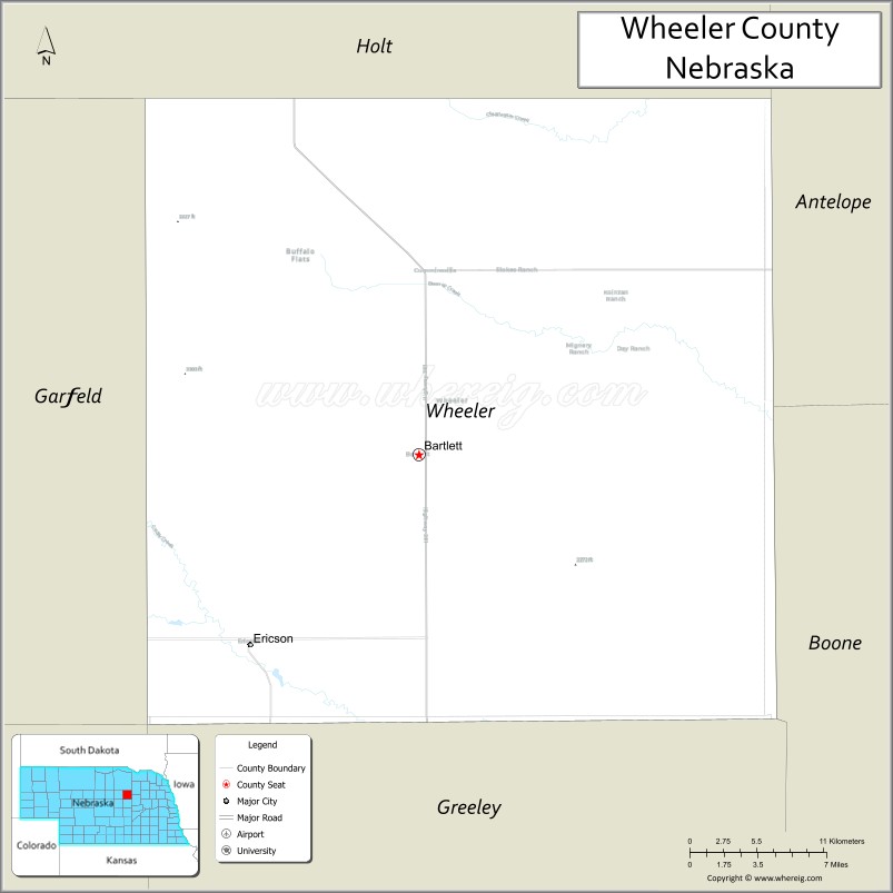
About Wheeler County Map, Nebraska: The map showing the county boundary, county seat, major cities, highways, water bodies and neighbouring counties.
Related Nebraska Maps & Info
Map of Wheeler County, Nebraska
Wheeler County is a county located in the U.S. state of Nebraska. It's county seat is Bartlett. As per 2020 census, the population of Wheeler County is 795 people and population density is square miles. According to the United States Census Bureau, the county has a total area of 575 sq mi (1,489 km2). Wheeler County was established on 1877.
Wheeler County Facts
| Continent | North America |
| Country | United States |
| State | Nebraska |
| County Seat | Bartlett |
| Largest City/Town | Bartlett |
| Established | 1877 |
| Total Area | 576 sq mi (1,492 sq km) |
| Land Area | 575 sq mi (1,489 sq km) |
| Water Area | 1 sq mi (2.6 sq km) |
| Population | 774 (Census 2020) |
| Population Density | 1.3 people per sq mi |
| Time Zone | Central Time Zone |
| Major Highways | Nebraska Highway 70, Nebraska Highway 91, Nebraska Highway 95 |
| Major Rivers | North Loup River, Cedar River nearby region |
| Neighboring Counties | Garfield County, Holt County, Boone County, Greeley County, Valley County |
| Famous For | Sandhills prairie landscapes, ranching, and quiet rural communities |
| Top Attractions | North Loup River recreation areas, Nebraska Sandhills scenery, and Wheeler County Historical exhibits |
| Official Website | Official Website |
About Wheeler County, Nebraska
Wheeler County is located in central Nebraska within the Sandhills transition region and was established in 1877. The county seat and largest village is Bartlett. The county is known for ranching, rolling prairie landscapes, scenic river valleys, and peaceful rural surroundings in central Nebraska.
Cities and Towns in Wheeler County, Nebraska
| City/Town | Population (Census 2020) | Latitude & Longitude |
|---|---|---|
| Bartlett (county seat) | 109 | 41.8850°N, 98.5528°W |
| Ericson | 92 | 41.7808°N, 98.6828°W |
Golf Courses in Wheeler County, Nebraska
| Golf Course | Location | Latitude & Longitude |
|---|---|---|
| Bartlett Prairie Golf Area | Bartlett | 41.8892°N, 98.5583°W |
| Ericson Community Golf Grounds | Ericson | 41.7856°N, 98.6872°W |
Roads and Highways in Wheeler County, Nebraska
Major highways connect the county to neighboring Sandhills and central Nebraska communities.
- Nebraska Highway 70 - east-west highway serving ranching and agricultural regions
- Nebraska Highway 91 - route linking central Nebraska communities and prairie areas
- Nebraska Highway 95 - regional connector serving rural villages and recreation areas
Neighboring Counties of Wheeler County
- Holt County (north)
- Boone County (east)
- Greeley County (south)
- Valley County (west)
- Garfield County (northwest)
What Are the Top Attractions in Wheeler County, Nebraska
The county offers a mix of natural, recreational, and rural attractions.
- North Loup River Recreation Areas - opportunities for fishing, kayaking, camping, and wildlife observation
- Nebraska Sandhills Scenery - rolling prairie landscapes and open grassland views
- Wheeler County Historical Exhibits - displays highlighting pioneer and ranching history
- Ericson Community Parks - outdoor gathering spaces and recreation areas
- Bartlett Historic Community Area - small-town atmosphere with local history and rural charm
- Prairie Scenic Drives - countryside routes featuring ranchlands and river valleys
- Outdoor Recreation Areas - hunting, hiking, camping, photography, and birdwatching opportunities
- Cedar River Nearby Natural Areas - scenic environments ideal for wildlife viewing
- Dark Sky Viewing Locations - remote prairie areas excellent for astronomy and night photography
- Ranching Heritage Landscapes - traditional cattle ranch country across central Nebraska
What Is the Distance from Wheeler County to Nearby Cities
The following distances are measured by road (driving).
- Bartlett to Ord (Valley County), Nebraska - 38 mi (61 km)
- Bartlett to Grand Island (Hall County), Nebraska - 102 mi (164 km)
- Bartlett to Kearney (Buffalo County), Nebraska - 90 mi (145 km)
- Bartlett to Norfolk (Madison County), Nebraska - 105 mi (169 km)
- Bartlett to North Platte (Lincoln County), Nebraska - 176 mi (283 km)
- Bartlett to Columbus (Platte County), Nebraska - 115 mi (185 km)
- Bartlett to Lincoln (Lancaster County), Nebraska - 192 mi (309 km)
- Bartlett to Omaha (Douglas County), Nebraska - 244 mi (393 km)
- Bartlett to Sioux City, Iowa - 221 mi (356 km)
- Bartlett to Denver, Colorado - 439 mi (707 km)
- Bartlett to Kansas City, Missouri - 362 mi (583 km)
- Bartlett to Rapid City, South Dakota - 332 mi (534 km)
FAQs about Wheeler County
Wheeler County is located in central Nebraska within the Sandhills transition region.
Wheeler County had a population of 774 according to Census 2020 data.
Wheeler County is known for Sandhills prairie landscapes, ranching, and quiet rural communities.
The county is served by Nebraska Highway 70, Nebraska Highway 91, and Nebraska Highway 95.
Yes, Wheeler County has golf facilities including Bartlett Prairie Golf Area and Ericson community golf grounds.
References
- QuickFacts - U.S. Census Bureau
- United States Census Bureau
- United States Geological Survey (USGS)
- Official County Website
- Visit Nebraska
- Adams County Map
- Antelope County Map
- Arthur County Map
- Banner County Map
- Blaine County Map
- Boone County Map
- Box Butte County Map
- Boyd County Map
- Brown County Map
- Buffalo County Map
- Burt County Map
- Butler County Map
- Cass County Map
- Cedar County Map
- Chase County Map
- Cherry County Map
- Cheyenne County Map
- Clay County Map
- Colfax County Map
- Cuming County Map
- Custer County Map
- Dakota County Map
- Dawes County Map
- Dawson County Map
- Deuel County Map
- Dixon County Map
- Dodge County Map
- Douglas County Map
- Dundy County Map
- Fillmore County Map
- Franklin County Map
- Frontier County Map
- Furnas County Map
- Gage County Map
- Garden County Map
- Garfield County Map
- Gosper County Map
- Grant County Map
- Greeley County Map
- Hall County Map
- Hamilton County Map
- Harlan County Map
- Hayes County Map
- Hitchcock County Map
- Holt County Map
- Hooker County Map
- Howard County Map
- Jefferson County Map
- Johnson County Map
- Kearney County Map
- Keith County Map
- Keya Paha County Map
- Kimball County Map
- Knox County Map
- Lancaster County Map
- Lincoln County Map
- Logan County Map
- Loup County Map
- McPherson County Map
- Madison County Map
- Merrick County Map
- Morrill County Map
- Nance County Map
- Nemaha County Map
- Nuckolls County Map
- Otoe County Map
- Pawnee County Map
- Perkins County Map
- Phelps County Map
- Pierce County Map
- Platte County Map
- Polk County Map
- Red Willow County Map
- Richardson County Map
- Rock County Map
- Saline County Map
- Sarpy County Map
- Saunders County Map
- Scotts Bluff County Map
- Seward County Map
- Sheridan County Map
- Sherman County Map
- Sioux County Map
- Stanton County Map
- Thayer County Map
- Thomas County Map
- Thurston County Map
- Valley County Map
- Washington County Map
- Wayne County Map
- Webster County Map
- Wheeler County Map
- York County Map
- Alabama Counties
- Alaska boroughs
- Arizona Counties
- Arkansas Counties
- California County Map
- Colorado Counties
- Connecticut Counties
- Delaware Counties
- Florida County Map
- Georgia County Map
- Hawaii Counties
- Idaho Counties
- Illinois Counties
- Indiana Counties
- Iowa Counties
- Kansas Counties
- Kentucky Counties
- Louisiana Counties
- Maine Counties
- Maryland Counties
- Massachusetts Counties
- Michigan County Map
- Minnesota Counties
- Mississippi Counties
- Missouri Counties
- Montana Counties
- Nebraska Counties
- Nevada Counties
- New York Counties
- New Hampshire Counties
- New Jersey Counties
- New Mexico Counties
- North Carolina Counties
- North Dakota Counties
- Ohio County Map
- Oklahoma Counties
- Oregon Counties
- Pennsylvania Counties
- Rhode Island Counties
- South Carolina Counties
- South Dakota Counties
- Map of Tennessee
- Texas County Map
- Utah Counties
- Vermont Counties
- Virginia Counties
- Washington Counties
- West Virginia Counties
- Wisconsin Counties
- Wyoming Counties