Written and Fact-checked by Whereig Editors, Reviewed by Mukesh Kumar| Last Updated On: May 10, 2026
Map of Kearney County - Kearney County is a county located in the U.S. state of Nebraska. Kearney County Map showing cities, highways, important places and water bodies. Get Where is Kearney County located in the map, major cities in Kearney county, population, areas, and places of interest.
Map of Kearney County, Nebraska
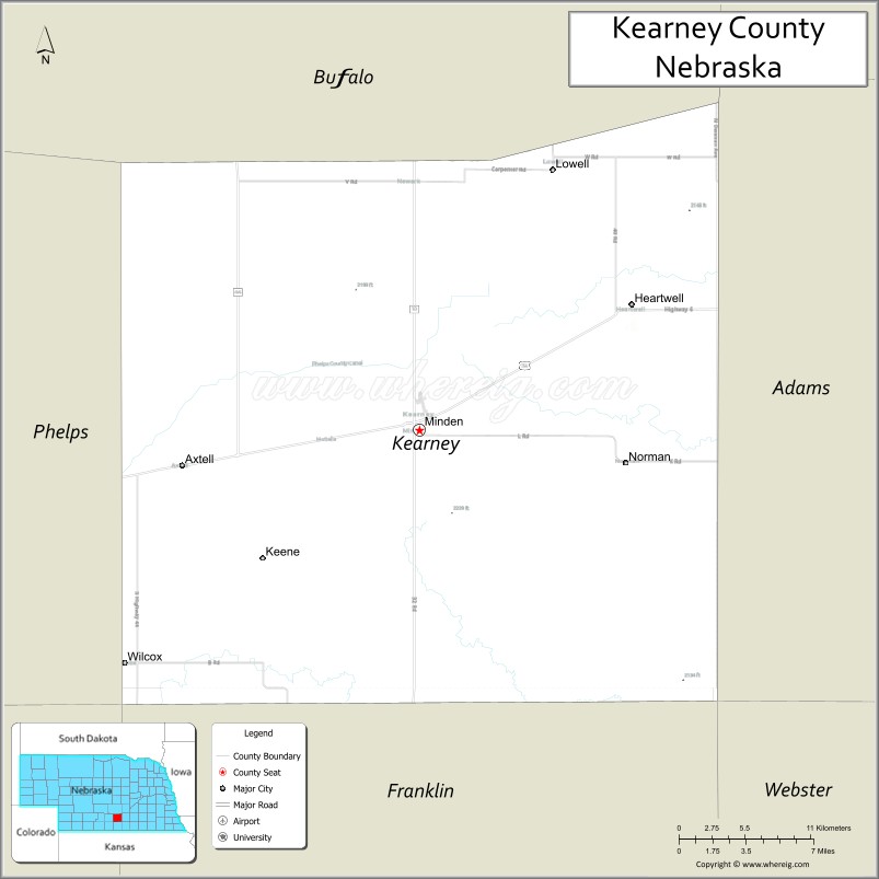
About Kearney County Map, Nebraska: The map showing the county boundary, county seat, major cities, highways, water bodies and neighbouring counties.
Related Nebraska Maps & Info
Map of Kearney County, Nebraska
Kearney County is a county located in the U.S. state of Nebraska. It's county seat is Minden. As per 2020 census, the population of Kearney County is 6674 people and population density is square miles. According to the United States Census Bureau, the county has a total area of 516 sq mi (1,336 km2). Kearney County was established on 1860.
Kearney County Facts
| Continent | North America |
| Country | United States |
| State | Nebraska |
| County Seat | Minden |
| Largest City/Town | Minden |
| Established | 1860 |
| Total Area | 516 sq mi (1,336 sq km) |
| Land Area | 516 sq mi (1,336 sq km) |
| Water Area | 0.7 sq mi (1.8 sq km) |
| Population | 6,307 (Census 2020) |
| Population Density | 12.2 people per sq mi |
| Time Zone | Central Time Zone |
| Major Highways | Interstate 80, U.S. Route 6, Nebraska Highway 10, Nebraska Highway 44 |
| Major Rivers | Platte River |
| Neighboring Counties | Buffalo County, Adams County, Franklin County, Phelps County, Harlan County |
| Famous For | Minden Opera House, agriculture, and the Nebraska prairie region |
| Top Attractions | Pioneer Village, Harold Warp Museum, and Minden Opera House |
| Official Website | Official Website |
About Kearney County, Nebraska
Kearney County is located in south-central Nebraska in the United States and was established in 1860. The county seat is Minden, which is also the largest city in the county. The county is known for agriculture, historic attractions, prairie landscapes, and cultural landmarks including museums and historic theaters.
Cities and Towns in Kearney County, Nebraska
| City/Town | Population (Census 2020) | Latitude & Longitude |
|---|---|---|
| Minden (county seat) | 2,977 | 40.4986°N, 98.9479°W |
| Axtell | 726 | 40.4781°N, 99.1256°W |
| Heartwell | 71 | 40.5997°N, 98.7937°W |
| Norman | 36 | 40.5295°N, 98.7870°W |
| Wilcox | 358 | 40.3933°N, 99.1504°W |
Golf Courses in Kearney County, Nebraska
| Golf Course | Location | Latitude & Longitude |
|---|---|---|
| Minden Country Club | Minden | 40.5007°N, 98.9522°W |
| Axtell Community Golf Course | Axtell | 40.4802°N, 99.1288°W |
Roads and Highways in Kearney County, Nebraska
Major highways connect the county to nearby regions and cities.
- Interstate 80 - major east-west interstate connecting Kearney County with Grand Island and North Platte
- U.S. Route 6 - historic highway running across south-central Nebraska communities
- Nebraska Highway 10 - regional highway linking Minden with Holdrege and surrounding counties
- Nebraska Highway 44 - route serving local agricultural communities and rural areas
Neighboring Counties of Kearney County
- Buffalo County (north)
- Phelps County (east)
- Adams County (southeast)
- Franklin County (south)
- Harlan County (southwest)
What Are the Top Attractions in Kearney County, Nebraska
The county offers a mix of natural and cultural attractions.
- Pioneer Village - large museum complex featuring historic transportation, antiques, and Americana collections
- Harold Warp Pioneer Village Museum - famous museum showcasing American history and artifacts
- Minden Opera House - restored historic theater and performing arts venue in downtown Minden
- Platte River Prairie Areas - scenic natural landscapes with wildlife viewing opportunities
- Minden Downtown Historic District - local shops, restaurants, and historic architecture
- Axtell Community Park - recreation area with picnic facilities and sports fields
- Wilcox Prairie Landscapes - countryside scenery ideal for photography and scenic drives
- Heartwell Community Grounds - local gathering and recreation area
- Kearney County Fairgrounds - venue for county fairs, livestock events, and festivals
- Rural Scenic Drives - Nebraska prairie and farmland routes across the county
What Is the Distance from Kearney County to Nearby Cities
The following distances are measured by road (driving).
- Minden to Kearney (Buffalo County), Nebraska - 28 mi (45 km)
- Minden to Hastings (Adams County), Nebraska - 39 mi (63 km)
- Minden to Grand Island (Hall County), Nebraska - 61 mi (98 km)
- Minden to Holdrege (Phelps County), Nebraska - 23 mi (37 km)
- Minden to Lexington (Dawson County), Nebraska - 56 mi (90 km)
- Minden to North Platte (Lincoln County), Nebraska - 110 mi (177 km)
- Minden to York (York County), Nebraska - 74 mi (119 km)
- Minden to Columbus (Platte County), Nebraska - 106 mi (171 km)
- Minden to Lincoln (Lancaster County), Nebraska - 133 mi (214 km)
- Minden to Omaha (Douglas County), Nebraska - 192 mi (309 km)
- Minden to McCook (Red Willow County), Nebraska - 111 mi (179 km)
- Minden to Denver, Colorado - 356 mi (573 km)
FAQs about Kearney County
Kearney County is located in south-central Nebraska in the United States.
Kearney County had a population of 6,307 according to Census 2020 data.
Kearney County is known for agriculture, historic museums, and the Minden Opera House.
The county is served by Interstate 80, U.S. Route 6, Nebraska Highway 10, and Nebraska Highway 44.
Yes, Kearney County has golf facilities including Minden Country Club and Axtell Community Golf Course.
References
- QuickFacts - U.S. Census Bureau
- United States Census Bureau
- United States Geological Survey (USGS)
- National Geodetic Survey
- Official County Website
- Adams County Map
- Antelope County Map
- Arthur County Map
- Banner County Map
- Blaine County Map
- Boone County Map
- Box Butte County Map
- Boyd County Map
- Brown County Map
- Buffalo County Map
- Burt County Map
- Butler County Map
- Cass County Map
- Cedar County Map
- Chase County Map
- Cherry County Map
- Cheyenne County Map
- Clay County Map
- Colfax County Map
- Cuming County Map
- Custer County Map
- Dakota County Map
- Dawes County Map
- Dawson County Map
- Deuel County Map
- Dixon County Map
- Dodge County Map
- Douglas County Map
- Dundy County Map
- Fillmore County Map
- Franklin County Map
- Frontier County Map
- Furnas County Map
- Gage County Map
- Garden County Map
- Garfield County Map
- Gosper County Map
- Grant County Map
- Greeley County Map
- Hall County Map
- Hamilton County Map
- Harlan County Map
- Hayes County Map
- Hitchcock County Map
- Holt County Map
- Hooker County Map
- Howard County Map
- Jefferson County Map
- Johnson County Map
- Kearney County Map
- Keith County Map
- Keya Paha County Map
- Kimball County Map
- Knox County Map
- Lancaster County Map
- Lincoln County Map
- Logan County Map
- Loup County Map
- McPherson County Map
- Madison County Map
- Merrick County Map
- Morrill County Map
- Nance County Map
- Nemaha County Map
- Nuckolls County Map
- Otoe County Map
- Pawnee County Map
- Perkins County Map
- Phelps County Map
- Pierce County Map
- Platte County Map
- Polk County Map
- Red Willow County Map
- Richardson County Map
- Rock County Map
- Saline County Map
- Sarpy County Map
- Saunders County Map
- Scotts Bluff County Map
- Seward County Map
- Sheridan County Map
- Sherman County Map
- Sioux County Map
- Stanton County Map
- Thayer County Map
- Thomas County Map
- Thurston County Map
- Valley County Map
- Washington County Map
- Wayne County Map
- Webster County Map
- Wheeler County Map
- York County Map
- Alabama Counties
- Alaska boroughs
- Arizona Counties
- Arkansas Counties
- California County Map
- Colorado Counties
- Connecticut Counties
- Delaware Counties
- Florida County Map
- Georgia County Map
- Hawaii Counties
- Idaho Counties
- Illinois Counties
- Indiana Counties
- Iowa Counties
- Kansas Counties
- Kentucky Counties
- Louisiana Counties
- Maine Counties
- Maryland Counties
- Massachusetts Counties
- Michigan County Map
- Minnesota Counties
- Mississippi Counties
- Missouri Counties
- Montana Counties
- Nebraska Counties
- Nevada Counties
- New York Counties
- New Hampshire Counties
- New Jersey Counties
- New Mexico Counties
- North Carolina Counties
- North Dakota Counties
- Ohio County Map
- Oklahoma Counties
- Oregon Counties
- Pennsylvania Counties
- Rhode Island Counties
- South Carolina Counties
- South Dakota Counties
- Map of Tennessee
- Texas County Map
- Utah Counties
- Vermont Counties
- Virginia Counties
- Washington Counties
- West Virginia Counties
- Wisconsin Counties
- Wyoming Counties