Written and Fact-checked by Whereig Editors, Reviewed by Mukesh Kumar| Last Updated On: May 10, 2026
Map of Hall County - Hall County is a county located in the U.S. state of Nebraska. Hall County Map showing cities, highways, important places and water bodies. Get Where is Hall County located in the map, major cities in Hall county, population, areas, and places of interest.
Map of Hall County, Nebraska
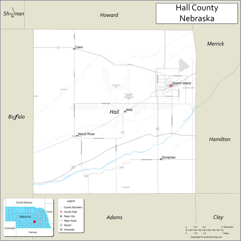
About Hall County Map, Nebraska: The map showing the county boundary, county seat, major cities, highways, water bodies and neighbouring counties.
Related Nebraska Maps & Info
Map of Hall County, Nebraska
Hall County is a county located in the U.S. state of Nebraska. It's county seat is Grand Island. As per 2020 census, the population of Hall County is 61979 people and population density is square miles. According to the United States Census Bureau, the county has a total area of 546 sq mi (1,414 km2). Hall County was established on 1858.
Hall County Facts
| Continent | North America |
| Country | United States |
| State | Nebraska |
| County Seat | Grand Island |
| Largest City/Town | Grand Island |
| Established | 1858 |
| Total Area | 552 sq mi (1,430 sq km) |
| Land Area | 546 sq mi (1,414 sq km) |
| Water Area | 6 sq mi (16 sq km) |
| Population | 62,895 (Census 2020) |
| Population Density | 115.2 people per sq mi |
| Time Zone | Central Time Zone |
| Major Highways | Interstate 80, U.S. Route 30, U.S. Route 34, Nebraska Highway 2 |
| Major Rivers | Platte River, Wood River |
| Neighboring Counties | Howard County, Merrick County, Hamilton County, Adams County, Buffalo County |
| Famous For | Nebraska State Fair, Crane Trust Nature Center, agriculture, and Grand Island tourism |
| Top Attractions | Stuhr Museum, Crane Trust Nature Center, Fonner Park, and Mormon Island State Recreation Area |
| Official Website | Official Website |
About Hall County, Nebraska
Hall County is located in central Nebraska in the United States and was established in 1858. The county seat is Grand Island, which is also the largest city in the county. The county is an important transportation and agricultural center along the Platte River and is known for tourism, recreation, and annual cultural events such as the Nebraska State Fair.
Cities and Towns in Hall County, Nebraska
| City/Town | Population (Census 2020) | Latitude & Longitude |
|---|---|---|
| Grand Island (county seat) | 53,131 | 40.9264°N, 98.3420°W |
| Wood River | 1,326 | 40.8206°N, 98.6001°W |
| Cairo | 805 | 40.8789°N, 98.6078°W |
| Alda | 647 | 40.8717°N, 98.4684°W |
| Doniphan | 829 | 40.7731°N, 98.3698°W |
| Hansen (CDP) | 94 | 40.8342°N, 98.1176°W |
Golf Courses in Hall County, Nebraska
| Golf Course | Location | Latitude & Longitude |
|---|---|---|
| Indianhead Golf Club | Grand Island | 40.9631°N, 98.3554°W |
| Riverside Golf Club | Grand Island | 40.9347°N, 98.3485°W |
| Centura Hills Golf Club | Cairo | 40.8772°N, 98.6411°W |
| Jackrabbit Run Golf Course | Grand Island | 40.8938°N, 98.3870°W |
Roads and Highways in Hall County, Nebraska
Major highways connect the county to nearby regions and cities.
- Interstate 80 - major east-west interstate connecting Grand Island with Lincoln and North Platte
- U.S. Route 30 - historic highway running parallel to the Platte River through the county
- U.S. Route 34 - route connecting Grand Island with southern Nebraska communities
- Nebraska Highway 2 - regional highway serving central Nebraska and the Sandhills region
Neighboring Counties of Hall County
- Howard County (north)
- Merrick County (east)
- Hamilton County (southeast)
- Adams County (south)
- Buffalo County (west)
What Are the Top Attractions in Hall County, Nebraska
The county offers a mix of natural and cultural attractions.
- Stuhr Museum of the Prairie Pioneer - museum showcasing pioneer history and historic buildings
- Crane Trust Nature Center - wildlife center famous for sandhill crane migration viewing
- Nebraska State Fair Grounds - major event venue hosting fairs, concerts, and exhibitions
- Fonner Park - horse racing and entertainment complex in Grand Island
- Mormon Island State Recreation Area - outdoor recreation area with camping, boating, and fishing
- Island Oasis Water Park - family-friendly water park with slides and pools
- Heartland Public Shooting Park - large outdoor shooting and sporting facility
- Platte River Corridor - scenic river environment known for birdwatching and wildlife
- Stolley Park - popular community park with picnic areas and playgrounds
- Railroad Town Historic District - historic district reflecting Grand Island railroad heritage
- Grand Island Downtown Area - shopping, restaurants, and cultural attractions in the city center
- Stuhr Road Prairie Areas - natural prairie landscapes and scenic drives
What Is the Distance from Hall County to Nearby Cities
The following distances are measured by road (driving).
- Grand Island to Kearney (Buffalo County), Nebraska - 44 mi (71 km)
- Grand Island to Hastings (Adams County), Nebraska - 26 mi (42 km)
- Grand Island to Columbus (Platte County), Nebraska - 84 mi (135 km)
- Grand Island to York (York County), Nebraska - 40 mi (64 km)
- Grand Island to Lexington (Dawson County), Nebraska - 87 mi (140 km)
- Grand Island to North Platte (Lincoln County), Nebraska - 141 mi (227 km)
- Grand Island to Norfolk (Madison County), Nebraska - 117 mi (188 km)
- Grand Island to Lincoln (Lancaster County), Nebraska - 93 mi (150 km)
- Grand Island to Omaha (Douglas County), Nebraska - 152 mi (245 km)
- Grand Island to Fremont (Dodge County), Nebraska - 123 mi (198 km)
- Grand Island to McCook (Red Willow County), Nebraska - 164 mi (264 km)
- Grand Island to Denver, Colorado - 389 mi (626 km)
FAQs about Hall County
Hall County is located in central Nebraska in the United States along the Platte River.
Hall County had a population of 62,895 according to Census 2020 data.
Hall County is known for the Nebraska State Fair, crane migration viewing, agriculture, and tourism in Grand Island.
The county is served by Interstate 80, U.S. Route 30, U.S. Route 34, and Nebraska Highway 2.
Yes, Hall County has several golf courses including Indianhead Golf Club, Riverside Golf Club, and Jackrabbit Run Golf Course.
References
- QuickFacts - U.S. Census Bureau
- United States Census Bureau
- United States Geological Survey (USGS)
- National Geodetic Survey
- Official County Website
- Adams County Map
- Antelope County Map
- Arthur County Map
- Banner County Map
- Blaine County Map
- Boone County Map
- Box Butte County Map
- Boyd County Map
- Brown County Map
- Buffalo County Map
- Burt County Map
- Butler County Map
- Cass County Map
- Cedar County Map
- Chase County Map
- Cherry County Map
- Cheyenne County Map
- Clay County Map
- Colfax County Map
- Cuming County Map
- Custer County Map
- Dakota County Map
- Dawes County Map
- Dawson County Map
- Deuel County Map
- Dixon County Map
- Dodge County Map
- Douglas County Map
- Dundy County Map
- Fillmore County Map
- Franklin County Map
- Frontier County Map
- Furnas County Map
- Gage County Map
- Garden County Map
- Garfield County Map
- Gosper County Map
- Grant County Map
- Greeley County Map
- Hall County Map
- Hamilton County Map
- Harlan County Map
- Hayes County Map
- Hitchcock County Map
- Holt County Map
- Hooker County Map
- Howard County Map
- Jefferson County Map
- Johnson County Map
- Kearney County Map
- Keith County Map
- Keya Paha County Map
- Kimball County Map
- Knox County Map
- Lancaster County Map
- Lincoln County Map
- Logan County Map
- Loup County Map
- McPherson County Map
- Madison County Map
- Merrick County Map
- Morrill County Map
- Nance County Map
- Nemaha County Map
- Nuckolls County Map
- Otoe County Map
- Pawnee County Map
- Perkins County Map
- Phelps County Map
- Pierce County Map
- Platte County Map
- Polk County Map
- Red Willow County Map
- Richardson County Map
- Rock County Map
- Saline County Map
- Sarpy County Map
- Saunders County Map
- Scotts Bluff County Map
- Seward County Map
- Sheridan County Map
- Sherman County Map
- Sioux County Map
- Stanton County Map
- Thayer County Map
- Thomas County Map
- Thurston County Map
- Valley County Map
- Washington County Map
- Wayne County Map
- Webster County Map
- Wheeler County Map
- York County Map
- Alabama Counties
- Alaska boroughs
- Arizona Counties
- Arkansas Counties
- California County Map
- Colorado Counties
- Connecticut Counties
- Delaware Counties
- Florida County Map
- Georgia County Map
- Hawaii Counties
- Idaho Counties
- Illinois Counties
- Indiana Counties
- Iowa Counties
- Kansas Counties
- Kentucky Counties
- Louisiana Counties
- Maine Counties
- Maryland Counties
- Massachusetts Counties
- Michigan County Map
- Minnesota Counties
- Mississippi Counties
- Missouri Counties
- Montana Counties
- Nebraska Counties
- Nevada Counties
- New York Counties
- New Hampshire Counties
- New Jersey Counties
- New Mexico Counties
- North Carolina Counties
- North Dakota Counties
- Ohio County Map
- Oklahoma Counties
- Oregon Counties
- Pennsylvania Counties
- Rhode Island Counties
- South Carolina Counties
- South Dakota Counties
- Map of Tennessee
- Texas County Map
- Utah Counties
- Vermont Counties
- Virginia Counties
- Washington Counties
- West Virginia Counties
- Wisconsin Counties
- Wyoming Counties