Written and Fact-checked by Whereig Editors, Reviewed by Mukesh Kumar| Last Updated On: May 10, 2026
Map of Scotts Bluff County - Scotts Bluff County is a county located in the U.S. state of Nebraska. Scotts Bluff County Map showing cities, highways, important places and water bodies. Get Where is Scotts Bluff County located in the map, major cities in Scotts Bluff county, population, areas, and places of interest.
Map of Scotts Bluff County, Nebraska
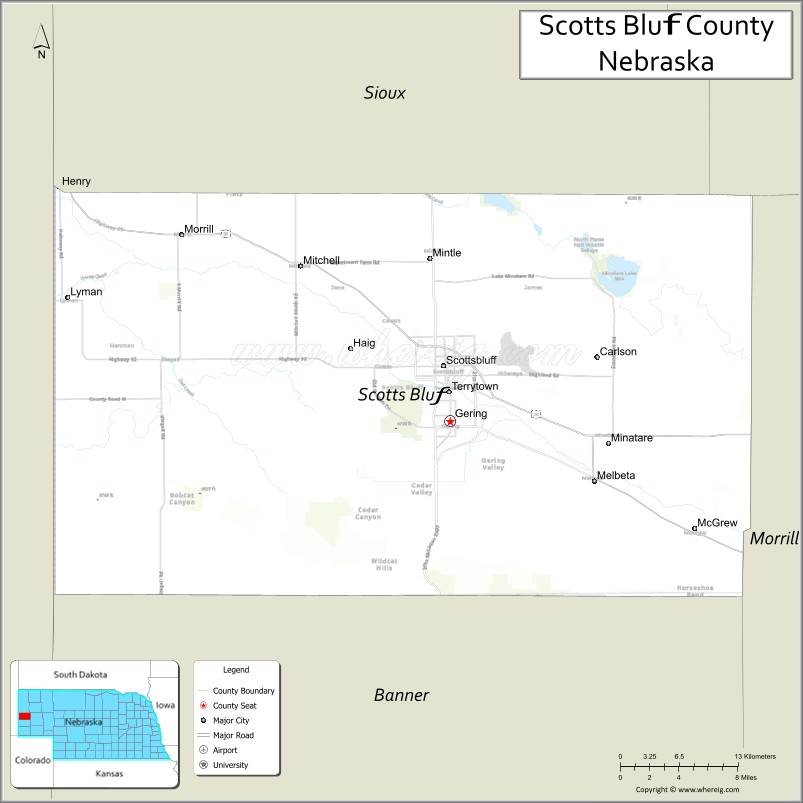
About Scotts Bluff County Map, Nebraska: The map showing the county boundary, county seat, major cities, highways, water bodies and neighbouring counties.
Related Nebraska Maps & Info
Map of Scotts Bluff County, Nebraska
Scotts Bluff County is a county located in the U.S. state of Nebraska. It's county seat is Gering. As per 2020 census, the population of Scotts Bluff County is 35745 people and population density is square miles. According to the United States Census Bureau, the county has a total area of 739 sq mi (1,914 km2). Scotts Bluff County was established on 1888.
Scotts Bluff County Facts
| Continent | North America |
| Country | United States |
| State | Nebraska |
| County Seat | Gering |
| Largest City/Town | Scottsbluff |
| Established | 1888 |
| Total Area | 745 sq mi (1,930 sq km) |
| Land Area | 739 sq mi (1,914 sq km) |
| Water Area | 6 sq mi (16 sq km) |
| Population | 36,084 (Census 2020) |
| Population Density | 48.8 people per sq mi |
| Time Zone | Mountain Time Zone |
| Major Highways | U.S. Route 26, Nebraska Highway 71, Nebraska Highway 92 |
| Major Rivers | North Platte River |
| Neighboring Counties | Sioux County, Banner County, Morrill County, Box Butte County, Goshen County (Wyoming) |
| Famous For | Scotts Bluff National Monument, Oregon Trail history, and western Nebraska landscapes |
| Top Attractions | Scotts Bluff National Monument, Riverside Discovery Center, and Legacy of the Plains Museum |
| Official Website | Official Website |
About Scotts Bluff County, Nebraska
Scotts Bluff County is located in western Nebraska along the North Platte River and was established in 1888. The county seat is Gering, while Scottsbluff is the largest city in the county. The county is known for Oregon Trail history, dramatic rock formations, agriculture, and outdoor recreation opportunities in western Nebraska.
Cities and Towns in Scotts Bluff County, Nebraska
| City/Town | Population (Census 2020) | Latitude & Longitude |
|---|---|---|
| Scottsbluff | 14,732 | 41.8666°N, 103.6672°W |
| Gering (county seat) | 8,564 | 41.8258°N, 103.6616°W |
| Mitchell | 1,548 | 41.9400°N, 103.8083°W |
| Minatare | 816 | 41.8092°N, 103.5022°W |
| Terrytown | 1,198 | 41.8478°N, 103.6677°W |
| Lyman | 341 | 41.9172°N, 103.9583°W |
| Melbeta | 112 | 41.7778°N, 103.4761°W |
Golf Courses in Scotts Bluff County, Nebraska
| Golf Course | Location | Latitude & Longitude |
|---|---|---|
| Monument Shadows Golf Course | Gering | 41.8303°N, 103.6678°W |
| Scotts Bluff Country Club | Scottsbluff | 41.8715°N, 103.6720°W |
| Lake Minatare Golf Course | Minatare nearby region | 41.9208°N, 103.4886°W |
Roads and Highways in Scotts Bluff County, Nebraska
Major highways connect the county to Wyoming, Colorado, and other Nebraska regions.
- U.S. Route 26 - historic highway following the Oregon Trail corridor through western Nebraska
- Nebraska Highway 71 - north-south route linking Scottsbluff with Colorado and northern Nebraska
- Nebraska Highway 92 - scenic route crossing western Nebraska and connecting local communities
Neighboring Counties of Scotts Bluff County
- Sioux County (north)
- Box Butte County (east)
- Morrill County (southeast)
- Banner County (south)
- Goshen County, Wyoming (west)
What Are the Top Attractions in Scotts Bluff County, Nebraska
The county offers a mix of natural, historical, and cultural attractions.
- Scotts Bluff National Monument - iconic Oregon Trail landmark featuring dramatic cliffs and scenic overlooks
- Riverside Discovery Center - zoo and educational facility with wildlife exhibits and family attractions
- Legacy of the Plains Museum - museum showcasing pioneer history, agriculture, and regional heritage
- Lake Minatare State Recreation Area - destination for boating, fishing, camping, and outdoor recreation
- North Platte River Scenic Areas - natural landscapes ideal for wildlife viewing and photography
- Gering Downtown District - local shops, restaurants, and historic architecture
- Wildcat Hills State Recreation Area Nearby Region - hiking, camping, and scenic western Nebraska landscapes
- Oregon Trail Historic Sites - landmarks connected to westward migration history
- Scotts Bluff County Fairgrounds - venue for fairs, rodeos, concerts, and festivals
- Outdoor Recreation Trails - hiking, biking, birdwatching, and photography opportunities
What Is the Distance from Scotts Bluff County to Nearby Cities
The following distances are measured by road (driving).
- Scottsbluff to Alliance (Box Butte County), Nebraska - 59 mi (95 km)
- Scottsbluff to Sidney (Cheyenne County), Nebraska - 92 mi (148 km)
- Scottsbluff to North Platte (Lincoln County), Nebraska - 200 mi (322 km)
- Scottsbluff to Greeley, Colorado - 136 mi (219 km)
- Scottsbluff to Cheyenne, Wyoming - 100 mi (161 km)
- Scottsbluff to Denver, Colorado - 190 mi (306 km)
- Scottsbluff to Rapid City, South Dakota - 202 mi (325 km)
- Scottsbluff to Grand Island (Hall County), Nebraska - 311 mi (500 km)
- Scottsbluff to Kearney (Buffalo County), Nebraska - 250 mi (402 km)
- Scottsbluff to Lincoln (Lancaster County), Nebraska - 442 mi (711 km)
- Scottsbluff to Omaha (Douglas County), Nebraska - 489 mi (787 km)
- Scottsbluff to Casper, Wyoming - 216 mi (348 km)
FAQs about Scotts Bluff County
Scotts Bluff County is located in western Nebraska along the North Platte River.
Scotts Bluff County had a population of 36,084 according to Census 2020 data.
Scotts Bluff County is known for Scotts Bluff National Monument, Oregon Trail history, and western Nebraska scenery.
The county is served by U.S. Route 26, Nebraska Highway 71, and Nebraska Highway 92.
Yes, Scotts Bluff County has golf facilities including Monument Shadows Golf Course and Scotts Bluff Country Club.
References
- QuickFacts - U.S. Census Bureau
- United States Census Bureau
- United States Geological Survey (USGS)
- Scotts Bluff National Monument
- Official County Website
- Adams County Map
- Antelope County Map
- Arthur County Map
- Banner County Map
- Blaine County Map
- Boone County Map
- Box Butte County Map
- Boyd County Map
- Brown County Map
- Buffalo County Map
- Burt County Map
- Butler County Map
- Cass County Map
- Cedar County Map
- Chase County Map
- Cherry County Map
- Cheyenne County Map
- Clay County Map
- Colfax County Map
- Cuming County Map
- Custer County Map
- Dakota County Map
- Dawes County Map
- Dawson County Map
- Deuel County Map
- Dixon County Map
- Dodge County Map
- Douglas County Map
- Dundy County Map
- Fillmore County Map
- Franklin County Map
- Frontier County Map
- Furnas County Map
- Gage County Map
- Garden County Map
- Garfield County Map
- Gosper County Map
- Grant County Map
- Greeley County Map
- Hall County Map
- Hamilton County Map
- Harlan County Map
- Hayes County Map
- Hitchcock County Map
- Holt County Map
- Hooker County Map
- Howard County Map
- Jefferson County Map
- Johnson County Map
- Kearney County Map
- Keith County Map
- Keya Paha County Map
- Kimball County Map
- Knox County Map
- Lancaster County Map
- Lincoln County Map
- Logan County Map
- Loup County Map
- McPherson County Map
- Madison County Map
- Merrick County Map
- Morrill County Map
- Nance County Map
- Nemaha County Map
- Nuckolls County Map
- Otoe County Map
- Pawnee County Map
- Perkins County Map
- Phelps County Map
- Pierce County Map
- Platte County Map
- Polk County Map
- Red Willow County Map
- Richardson County Map
- Rock County Map
- Saline County Map
- Sarpy County Map
- Saunders County Map
- Scotts Bluff County Map
- Seward County Map
- Sheridan County Map
- Sherman County Map
- Sioux County Map
- Stanton County Map
- Thayer County Map
- Thomas County Map
- Thurston County Map
- Valley County Map
- Washington County Map
- Wayne County Map
- Webster County Map
- Wheeler County Map
- York County Map
- Alabama Counties
- Alaska boroughs
- Arizona Counties
- Arkansas Counties
- California County Map
- Colorado Counties
- Connecticut Counties
- Delaware Counties
- Florida County Map
- Georgia County Map
- Hawaii Counties
- Idaho Counties
- Illinois Counties
- Indiana Counties
- Iowa Counties
- Kansas Counties
- Kentucky Counties
- Louisiana Counties
- Maine Counties
- Maryland Counties
- Massachusetts Counties
- Michigan County Map
- Minnesota Counties
- Mississippi Counties
- Missouri Counties
- Montana Counties
- Nebraska Counties
- Nevada Counties
- New York Counties
- New Hampshire Counties
- New Jersey Counties
- New Mexico Counties
- North Carolina Counties
- North Dakota Counties
- Ohio County Map
- Oklahoma Counties
- Oregon Counties
- Pennsylvania Counties
- Rhode Island Counties
- South Carolina Counties
- South Dakota Counties
- Map of Tennessee
- Texas County Map
- Utah Counties
- Vermont Counties
- Virginia Counties
- Washington Counties
- West Virginia Counties
- Wisconsin Counties
- Wyoming Counties