Written and Fact-checked by Whereig Editors, Reviewed by Mukesh Kumar| Last Updated On: May 10, 2026
Map of Boyd County - Boyd County is a county located in the U.S. state of Nebraska. Boyd County Map showing cities, highways, important places and water bodies. Get Where is Boyd County located in the map, major cities in Boyd county, population, areas, and places of interest.
Map of Boyd County, Nebraska
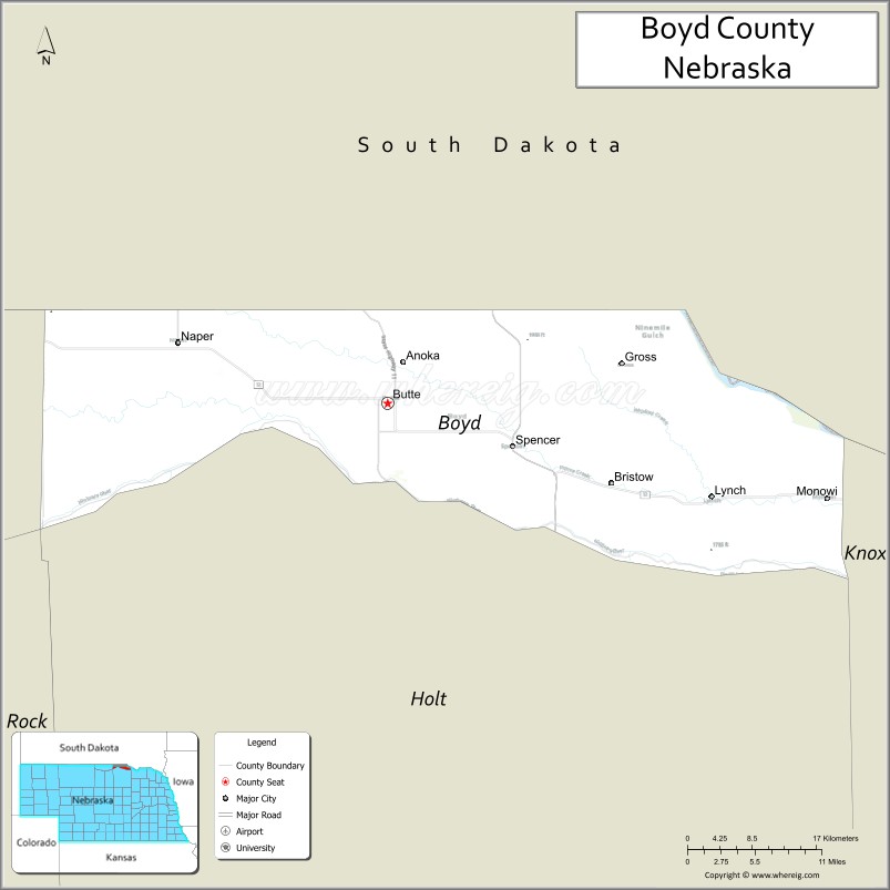
About Boyd County Map, Nebraska: The map showing the county boundary, county seat, major cities, highways, water bodies and neighbouring counties.
Related Nebraska Maps & Info
Map of Boyd County, Nebraska
Boyd County is a county located in the U.S. state of Nebraska. It's county seat is Butte. As per 2020 census, the population of Boyd County is 1789 people and population density is square miles. According to the United States Census Bureau, the county has a total area of 540 sq mi (1,399 km2). Boyd County was established on 1891.
Boyd County Facts
| Continent | North America |
| Country | United States |
| State | Nebraska |
| County Seat | Butte |
| Largest City/Town | Butte |
| Established | 1891 |
| Total Area | 543 sq mi (1,406 sq km) |
| Land Area | 540 sq mi (1,399 sq km) |
| Water Area | 3 sq mi (8 sq km) |
| Population | 1,810 (Census 2020) |
| Population Density | 3.4 people per sq mi |
| Time Zone | Central Time Zone (CT) |
| Major Highways | US 12, NE 11 |
| Major Rivers | Missouri River, Niobrara River nearby |
| Neighboring Counties | Keya Paha County, Holt County, Knox County, Gregory County (SD), Charles Mix County (SD) |
| Famous For | Missouri River recreation, ranching, prairie landscapes, fishing and hunting |
| Top Attractions | Missouri River recreation, Butte attractions, fishing and hunting areas, prairie scenic drives |
| Official Website | Official Website |
About Boyd County, Nebraska
Boyd County is located in north-central Nebraska in the United States and was established in 1891. The county seat and largest community is Butte. The county is known for ranching, Missouri River recreation, prairie landscapes, and excellent hunting and fishing opportunities.
Cities and Towns in Boyd County, Nebraska
| City/Town | Population (Census 2020) | Latitude & Longitude |
|---|---|---|
| Butte (county seat) | 286 | 42.9125°N, 98.8381°W |
| Spencer | 455 | 42.8814°N, 98.7012°W |
| Lynch | 194 | 42.8306°N, 98.4617°W |
| Naper | 85 | 42.9608°N, 99.0881°W |
| Bristow | 73 | 42.8572°N, 98.5834°W |
| Monowi | 1 | 42.8303°N, 98.3292°W |
Golf Courses in Boyd County, Nebraska
| Golf Course | Location | Latitude & Longitude |
|---|---|---|
| Butte Golf Course | Butte | 42.9168°N, 98.8452°W |
| Atkinson-Stuart Country Club nearby | Atkinson | 42.5298°N, 98.9891°W |
| Lakeview Golf Course nearby | Crofton | 42.7342°N, 97.4981°W |
| Winner Country Club nearby | Winner, South Dakota | 43.3858°N, 99.8621°W |
Roads and Highways in Boyd County, Nebraska
Major highways connect the county to northern Nebraska ranching communities and Missouri River recreation areas.
- US Highway 12 - important east-west highway across northern Nebraska
- Nebraska Highway 11 - regional north-south route serving prairie communities
Neighboring Counties of Boyd County
- Keya Paha County (west)
- Holt County (southwest)
- Knox County (east)
- Gregory County, South Dakota (north)
- Charles Mix County, South Dakota (northeast)
What Are the Top Attractions in Boyd County, Nebraska
The county offers a mix of Missouri River recreation, prairie scenery, and rural Nebraska heritage.
- Missouri River recreation - boating, fishing, kayaking, and scenic river activities
- Butte attractions - local restaurants, community events, and prairie heritage
- Fishing and hunting areas - pheasant, deer, turkey, and waterfowl recreation
- Prairie scenic drives - rolling grasslands and countryside landscapes
- Niobrara River nearby recreation - canoeing, tubing, and wildlife viewing
- Birdwatching and wildlife habitats - prairie ecosystems and migratory birds
- Camping and RV parks nearby - outdoor recreation and family travel destinations
- Photography and sunset viewing across prairie landscapes - scenic outdoor experiences
- Historic ranching communities - cowboy culture and western traditions
- Monowi attractions - famous tiny incorporated village with one resident
- Regional rodeos and county fairs - celebrating ranching and agriculture traditions
- Horseback riding opportunities across prairie landscapes - outdoor western adventures
- Winter recreation and ice fishing nearby - seasonal outdoor activities
- Nearby South Dakota Missouri River attractions - additional recreation and scenic destinations
What Is the Distance from Boyd County to Nearby Cities
The following distances are measured by road (driving).
- Butte to O'Neill (Holt County), Nebraska - 50 mi (80 km)
- Butte to Norfolk (Madison County), Nebraska - 132 mi (212 km)
- Butte to Sioux Falls (Minnehaha County), South Dakota - 184 mi (296 km)
- Butte to Pierre (Hughes County), South Dakota - 165 mi (266 km)
- Butte to Sioux City (Woodbury County), Iowa - 178 mi (286 km)
- Butte to Lincoln (Lancaster County), Nebraska - 251 mi (404 km)
- Butte to Omaha (Douglas County), Nebraska - 253 mi (407 km)
- Butte to North Platte (Lincoln County), Nebraska - 255 mi (410 km)
- Butte to Rapid City (Pennington County), South Dakota - 296 mi (476 km)
- Butte to Minneapolis (Hennepin County), Minnesota - 394 mi (634 km)
- Butte to Denver (Denver County), Colorado - 523 mi (842 km)
- Butte to Fargo (Cass County), North Dakota - 427 mi (687 km)
FAQs about Boyd County
Boyd County is located in north-central Nebraska along the Missouri River near South Dakota.
Boyd County had a population of 1,810 according to the 2020 United States Census.
Boyd County is known for Missouri River recreation, ranching, prairie landscapes, and hunting and fishing opportunities.
The major highways include US Highway 12 and Nebraska Highway 11.
Popular attractions include Missouri River recreation areas, prairie scenic drives, fishing and hunting destinations, and the unique village of Monowi.
References
- QuickFacts - U.S. Census Bureau
- United States Census Bureau
- United States Geological Survey (USGS)
- National Geodetic Survey
- Official Website
- Adams County Map
- Antelope County Map
- Arthur County Map
- Banner County Map
- Blaine County Map
- Boone County Map
- Box Butte County Map
- Boyd County Map
- Brown County Map
- Buffalo County Map
- Burt County Map
- Butler County Map
- Cass County Map
- Cedar County Map
- Chase County Map
- Cherry County Map
- Cheyenne County Map
- Clay County Map
- Colfax County Map
- Cuming County Map
- Custer County Map
- Dakota County Map
- Dawes County Map
- Dawson County Map
- Deuel County Map
- Dixon County Map
- Dodge County Map
- Douglas County Map
- Dundy County Map
- Fillmore County Map
- Franklin County Map
- Frontier County Map
- Furnas County Map
- Gage County Map
- Garden County Map
- Garfield County Map
- Gosper County Map
- Grant County Map
- Greeley County Map
- Hall County Map
- Hamilton County Map
- Harlan County Map
- Hayes County Map
- Hitchcock County Map
- Holt County Map
- Hooker County Map
- Howard County Map
- Jefferson County Map
- Johnson County Map
- Kearney County Map
- Keith County Map
- Keya Paha County Map
- Kimball County Map
- Knox County Map
- Lancaster County Map
- Lincoln County Map
- Logan County Map
- Loup County Map
- McPherson County Map
- Madison County Map
- Merrick County Map
- Morrill County Map
- Nance County Map
- Nemaha County Map
- Nuckolls County Map
- Otoe County Map
- Pawnee County Map
- Perkins County Map
- Phelps County Map
- Pierce County Map
- Platte County Map
- Polk County Map
- Red Willow County Map
- Richardson County Map
- Rock County Map
- Saline County Map
- Sarpy County Map
- Saunders County Map
- Scotts Bluff County Map
- Seward County Map
- Sheridan County Map
- Sherman County Map
- Sioux County Map
- Stanton County Map
- Thayer County Map
- Thomas County Map
- Thurston County Map
- Valley County Map
- Washington County Map
- Wayne County Map
- Webster County Map
- Wheeler County Map
- York County Map
- Alabama Counties
- Alaska boroughs
- Arizona Counties
- Arkansas Counties
- California County Map
- Colorado Counties
- Connecticut Counties
- Delaware Counties
- Florida County Map
- Georgia County Map
- Hawaii Counties
- Idaho Counties
- Illinois Counties
- Indiana Counties
- Iowa Counties
- Kansas Counties
- Kentucky Counties
- Louisiana Counties
- Maine Counties
- Maryland Counties
- Massachusetts Counties
- Michigan County Map
- Minnesota Counties
- Mississippi Counties
- Missouri Counties
- Montana Counties
- Nebraska Counties
- Nevada Counties
- New York Counties
- New Hampshire Counties
- New Jersey Counties
- New Mexico Counties
- North Carolina Counties
- North Dakota Counties
- Ohio County Map
- Oklahoma Counties
- Oregon Counties
- Pennsylvania Counties
- Rhode Island Counties
- South Carolina Counties
- South Dakota Counties
- Map of Tennessee
- Texas County Map
- Utah Counties
- Vermont Counties
- Virginia Counties
- Washington Counties
- West Virginia Counties
- Wisconsin Counties
- Wyoming Counties