Written and Fact-checked by Whereig Editors, Reviewed by Mukesh Kumar| Last Updated On: May 10, 2026
Map of Holt County - Holt County is a county located in the U.S. state of Nebraska. Holt County Map showing cities, highways, important places and water bodies. Get Where is Holt County located in the map, major cities in Holt county, population, areas, and places of interest.
Map of Holt County, Nebraska
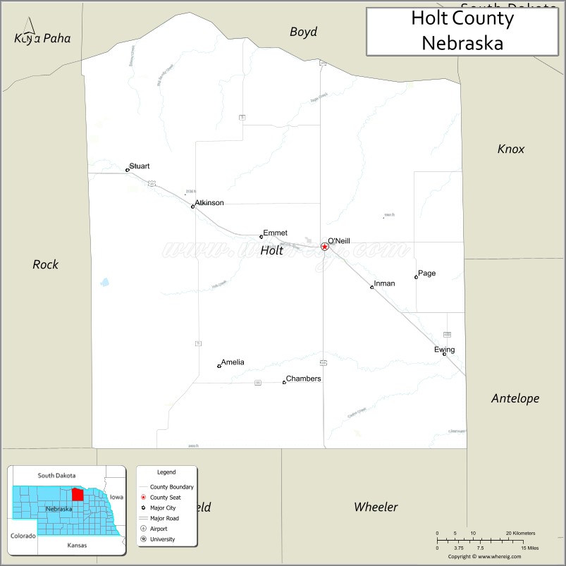
About Holt County Map, Nebraska: The map showing the county boundary, county seat, major cities, highways, water bodies and neighbouring counties.
Related Nebraska Maps & Info
Map of Holt County, Nebraska
Holt County is a county located in the U.S. state of Nebraska. It's county seat is O'Neill. As per 2020 census, the population of Holt County is 10049 people and population density is square miles. According to the United States Census Bureau, the county has a total area of 2,413 sq mi (6,250 km2). Holt County was established on 1860.
Holt County Facts
| Continent | North America |
| Country | United States |
| State | Nebraska |
| County Seat | O'Neill |
| Largest City/Town | O'Neill |
| Established | 1862 |
| Total Area | 2,412 sq mi (6,247 sq km) |
| Land Area | 2,407 sq mi (6,234 sq km) |
| Water Area | 5 sq mi (13 sq km) |
| Population | 10,127 (Census 2020) |
| Population Density | 4.2 people per sq mi |
| Time Zone | Central Time Zone |
| Major Highways | U.S. Route 20, U.S. Route 281, Nebraska Highway 11 |
| Major Rivers | Niobrara River, Elkhorn River |
| Neighboring Counties | Boyd County, Rock County, Garfield County, Wheeler County, Antelope County, Knox County |
| Famous For | Sandhills landscapes, ranching, Irish heritage, and the city of O'Neill |
| Top Attractions | Niobrara River, O'Neill Irish Capital landmarks, and Fort Randall Scenic Byway access |
| Official Website | Official Website |
About Holt County, Nebraska
Holt County is located in north-central Nebraska in the United States and was established in 1862. The county seat is O'Neill, which is also the largest city in the county. The county is known for its ranching economy, rolling Sandhills scenery, Irish cultural heritage, and outdoor recreation along the Niobrara and Elkhorn rivers.
Cities and Towns in Holt County, Nebraska
| City/Town | Population (Census 2020) | Latitude & Longitude |
|---|---|---|
| O'Neill (county seat) | 3,581 | 42.4578°N, 98.6479°W |
| Atkinson | 1,245 | 42.5314°N, 98.9793°W |
| Stuart | 590 | 42.5994°N, 99.1420°W |
| Ewing | 373 | 42.2592°N, 98.3462°W |
| Chambers | 268 | 42.2036°N, 98.7856°W |
| Inman | 113 | 42.3783°N, 98.5295°W |
| Page | 166 | 42.4175°N, 98.4181°W |
| Emmet | 48 | 42.4770°N, 98.8076°W |
Golf Courses in Holt County, Nebraska
| Golf Course | Location | Latitude & Longitude |
|---|---|---|
| O'Neill Country Club | O'Neill | 42.4540°N, 98.6527°W |
| Atkinson-Stuart Country Club | Atkinson | 42.5301°N, 98.9732°W |
| Ewing Golf Club | Ewing | 42.2610°N, 98.3435°W |
Roads and Highways in Holt County, Nebraska
Major highways connect the county to nearby regions and cities.
- U.S. Route 20 - major east-west highway connecting O'Neill with Valentine and Norfolk
- U.S. Route 281 - north-south route linking Holt County with South Dakota and central Nebraska
- Nebraska Highway 11 - scenic regional highway serving ranching communities and Sandhills areas
Neighboring Counties of Holt County
- Boyd County (north)
- Rock County (west)
- Garfield County (southwest)
- Wheeler County (south)
- Antelope County (southeast)
- Knox County (east)
What Are the Top Attractions in Holt County, Nebraska
The county offers a mix of natural and cultural attractions.
- Niobrara River - scenic river popular for canoeing, tubing, fishing, and wildlife viewing
- O'Neill Irish Capital Landmarks - attractions celebrating the city's Irish heritage and culture
- Elkhorn River Scenic Areas - natural landscapes with fishing and birdwatching opportunities
- Fort Randall Scenic Byway Access - scenic driving route through Nebraska prairie and Sandhills landscapes
- Holt County Historical Museum - museum displaying pioneer and ranching history
- Atkinson Downtown Area - local shops, restaurants, and historic buildings
- Stuart Community Park - recreation area with picnic facilities and sports areas
- Sandhills Prairie Scenic Drives - countryside routes featuring rolling dunes and ranchlands
- Chambers Wildlife Areas - habitats supporting prairie birds and native wildlife
- Ewing Recreation Grounds - community sports and outdoor event facilities
- Page Prairie Landscapes - open grassland scenery and rural photography locations
What Is the Distance from Holt County to Nearby Cities
The following distances are measured by road (driving).
- O'Neill to Norfolk (Madison County), Nebraska - 75 mi (121 km)
- O'Neill to Valentine (Cherry County), Nebraska - 88 mi (142 km)
- O'Neill to Ainsworth (Brown County), Nebraska - 56 mi (90 km)
- O'Neill to Albion (Boone County), Nebraska - 68 mi (109 km)
- O'Neill to Broken Bow (Custer County), Nebraska - 109 mi (175 km)
- O'Neill to Columbus (Platte County), Nebraska - 120 mi (193 km)
- O'Neill to Grand Island (Hall County), Nebraska - 161 mi (259 km)
- O'Neill to Kearney (Buffalo County), Nebraska - 181 mi (291 km)
- O'Neill to Lincoln (Lancaster County), Nebraska - 223 mi (359 km)
- O'Neill to Omaha (Douglas County), Nebraska - 211 mi (340 km)
- O'Neill to Sioux City, Iowa - 131 mi (211 km)
- O'Neill to Denver, Colorado - 421 mi (678 km)
FAQs about Holt County
Holt County is located in north-central Nebraska in the United States.
Holt County had a population of 10,127 according to Census 2020 data.
Holt County is known for Sandhills ranching, Irish heritage, prairie scenery, and outdoor recreation.
The county is served by U.S. Route 20, U.S. Route 281, and Nebraska Highway 11.
Yes, Holt County has golf facilities including O'Neill Country Club, Atkinson-Stuart Country Club, and Ewing Golf Club.
References
- QuickFacts - U.S. Census Bureau
- United States Census Bureau
- United States Geological Survey (USGS)
- National Geodetic Survey
- Official County Website
- Adams County Map
- Antelope County Map
- Arthur County Map
- Banner County Map
- Blaine County Map
- Boone County Map
- Box Butte County Map
- Boyd County Map
- Brown County Map
- Buffalo County Map
- Burt County Map
- Butler County Map
- Cass County Map
- Cedar County Map
- Chase County Map
- Cherry County Map
- Cheyenne County Map
- Clay County Map
- Colfax County Map
- Cuming County Map
- Custer County Map
- Dakota County Map
- Dawes County Map
- Dawson County Map
- Deuel County Map
- Dixon County Map
- Dodge County Map
- Douglas County Map
- Dundy County Map
- Fillmore County Map
- Franklin County Map
- Frontier County Map
- Furnas County Map
- Gage County Map
- Garden County Map
- Garfield County Map
- Gosper County Map
- Grant County Map
- Greeley County Map
- Hall County Map
- Hamilton County Map
- Harlan County Map
- Hayes County Map
- Hitchcock County Map
- Holt County Map
- Hooker County Map
- Howard County Map
- Jefferson County Map
- Johnson County Map
- Kearney County Map
- Keith County Map
- Keya Paha County Map
- Kimball County Map
- Knox County Map
- Lancaster County Map
- Lincoln County Map
- Logan County Map
- Loup County Map
- McPherson County Map
- Madison County Map
- Merrick County Map
- Morrill County Map
- Nance County Map
- Nemaha County Map
- Nuckolls County Map
- Otoe County Map
- Pawnee County Map
- Perkins County Map
- Phelps County Map
- Pierce County Map
- Platte County Map
- Polk County Map
- Red Willow County Map
- Richardson County Map
- Rock County Map
- Saline County Map
- Sarpy County Map
- Saunders County Map
- Scotts Bluff County Map
- Seward County Map
- Sheridan County Map
- Sherman County Map
- Sioux County Map
- Stanton County Map
- Thayer County Map
- Thomas County Map
- Thurston County Map
- Valley County Map
- Washington County Map
- Wayne County Map
- Webster County Map
- Wheeler County Map
- York County Map
- Alabama Counties
- Alaska boroughs
- Arizona Counties
- Arkansas Counties
- California County Map
- Colorado Counties
- Connecticut Counties
- Delaware Counties
- Florida County Map
- Georgia County Map
- Hawaii Counties
- Idaho Counties
- Illinois Counties
- Indiana Counties
- Iowa Counties
- Kansas Counties
- Kentucky Counties
- Louisiana Counties
- Maine Counties
- Maryland Counties
- Massachusetts Counties
- Michigan County Map
- Minnesota Counties
- Mississippi Counties
- Missouri Counties
- Montana Counties
- Nebraska Counties
- Nevada Counties
- New York Counties
- New Hampshire Counties
- New Jersey Counties
- New Mexico Counties
- North Carolina Counties
- North Dakota Counties
- Ohio County Map
- Oklahoma Counties
- Oregon Counties
- Pennsylvania Counties
- Rhode Island Counties
- South Carolina Counties
- South Dakota Counties
- Map of Tennessee
- Texas County Map
- Utah Counties
- Vermont Counties
- Virginia Counties
- Washington Counties
- West Virginia Counties
- Wisconsin Counties
- Wyoming Counties