Written and Fact-checked by Whereig Editors, Reviewed by Mukesh Kumar| Last Updated On: May 10, 2026
Map of Douglas County - Douglas County is a county located in the U.S. state of Nebraska. Douglas County Map showing cities, highways, important places and water bodies. Get Where is Douglas County located in the map, major cities in Douglas county, population, areas, and places of interest.
Map of Douglas County, Nebraska
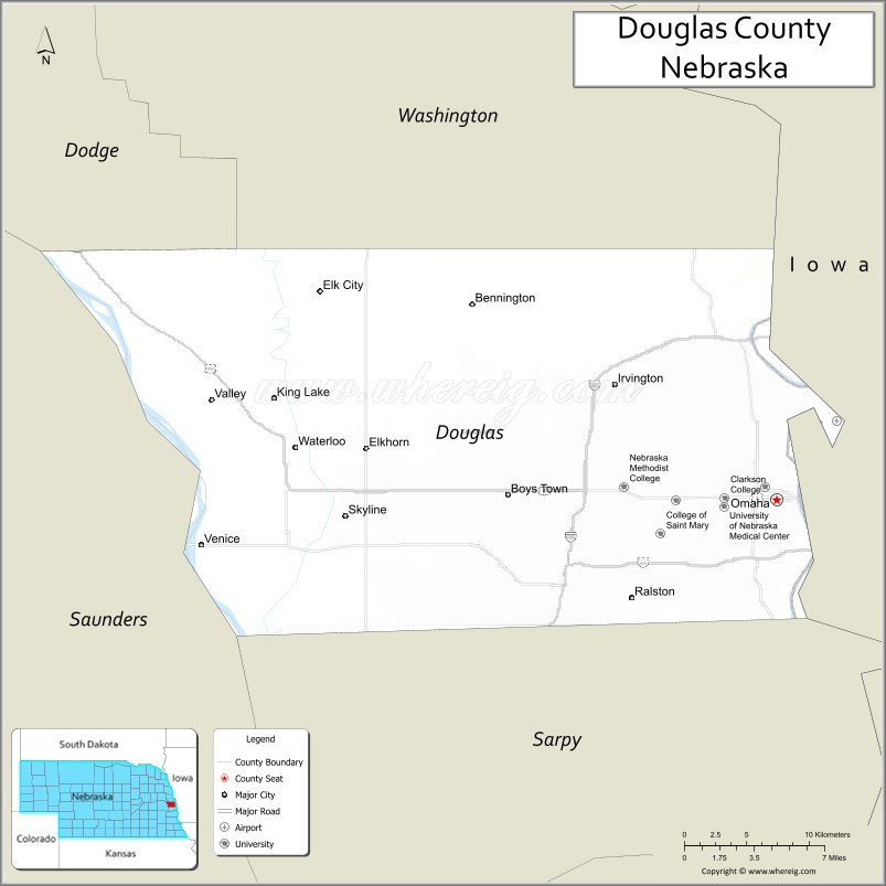
About Douglas County Map, Nebraska: The map showing the county boundary, county seat, major cities, highways, water bodies and neighbouring counties.
Related Nebraska Maps & Info
Map of Douglas County, Nebraska
Douglas County is a county located in the U.S. state of Nebraska. It's county seat is Omaha. As per 2020 census, the population of Douglas County is 585008 people and population density is square miles. According to the United States Census Bureau, the county has a total area of 331 sq mi (857 km2). Douglas County was established on 1854.p>
Douglas County Facts
| Continent | North America |
| Country | United States |
| State | Nebraska |
| County Seat | Omaha |
| Largest City/Town | Omaha |
| Established | 1854 |
| Total Area | 339 sq mi (878 sq km) |
| Land Area | 328 sq mi (850 sq km) |
| Water Area | 11 sq mi (28 sq km) |
| Population | 584,526 (Census 2020) |
| Population Density | 1,782 people per sq mi |
| Time Zone | Central Time Zone (CT) |
| Major Highways | Interstate 80, Interstate 480, US 6, US 75, US 275 |
| Major Rivers | Missouri River, Platte River |
| Neighboring Counties | Dodge County, Sarpy County, Saunders County, Washington County, Pottawattamie County (IA), Harrison County (IA) |
| Famous For | Omaha attractions, Henry Doorly Zoo, business headquarters, arts and entertainment |
| Top Attractions | Henry Doorly Zoo and Aquarium, Old Market District, CHI Health Center Omaha, Lauritzen Gardens |
| Official Website | Official Website |
About Douglas County, Nebraska
Douglas County is located in eastern Nebraska in the United States and was established in 1854. The county seat and largest city is Omaha, the largest city in Nebraska. The county is known for business and finance, cultural attractions, historic neighborhoods, sports venues, and major tourism destinations along the Missouri River.
Cities and Towns in Douglas County, Nebraska
| City/Town | Population (Census 2020) | Latitude & Longitude |
|---|---|---|
| Omaha (county seat) | 486,051 | 41.2565°N, 95.9345°W |
| Bennington | 1,458 | 41.3633°N, 96.1570°W |
| Valley | 3,194 | 41.3128°N, 96.3467°W |
| Waterloo | 935 | 41.2842°N, 96.2856°W |
| Ralston | 6,494 | 41.2053°N, 96.0411°W |
| Boys Town | 745 | 41.2661°N, 96.1253°W |
Golf Courses in Douglas County, Nebraska
| Golf Course | Location | Latitude & Longitude |
|---|---|---|
| Omaha Country Club | Omaha | 41.2748°N, 96.0345°W |
| Field Club of Omaha | Omaha | 41.2334°N, 95.9602°W |
| Tiburon Golf Club | Omaha | 41.1458°N, 96.1469°W |
| Johnny Goodman Golf Course | Omaha | 41.1839°N, 96.0877°W |
Roads and Highways in Douglas County, Nebraska
Douglas County is served by an extensive highway network connecting Omaha to regional and national transportation corridors.
- Interstate 80 - major east-west interstate highway across the United States
- Interstate 480 - downtown Omaha interstate connector
- US Highway 6 - historic east-west route through Omaha
- US Highway 75 - major north-south transportation corridor
- US Highway 275 - regional route connecting eastern Nebraska communities
Neighboring Counties of Douglas County
- Washington County (north)
- Dodge County (northwest)
- Saunders County (west)
- Sarpy County (south)
- Pottawattamie County, Iowa (east)
- Harrison County, Iowa (northeast)
What Are the Top Attractions in Douglas County, Nebraska
The county offers world-class attractions, entertainment venues, riverfront recreation, and cultural experiences.
- Henry Doorly Zoo and Aquarium - internationally recognized zoo and indoor rainforest attraction
- Old Market District - historic brick streets, restaurants, galleries, and entertainment venues
- CHI Health Center Omaha - concerts, sporting events, and convention center destination
- Lauritzen Gardens - botanical gardens and scenic walking paths
- Bob Kerrey Pedestrian Bridge - iconic bridge crossing the Missouri River into Iowa
- Joslyn Art Museum - art collections and cultural exhibitions
- The Durham Museum - railroad and regional history exhibits in a historic train station
- Gene Leahy Mall and riverfront parks - urban recreation and outdoor gathering spaces
- College World Series events - major annual baseball championship attraction
- Heartland of America Park - lakefront recreation and city skyline views
- Omaha Children’s Museum - interactive family-friendly exhibits and activities
- Shopping and dining districts - Midtown Crossing, Dundee, and Aksarben Village attractions
- Missouri River recreation - boating, kayaking, and scenic outdoor experiences
- Nearby strategic business headquarters and cultural institutions - reflecting Omaha’s economic importance
What Is the Distance from Douglas County to Nearby Cities
The following distances are measured by road (driving).
- Omaha to Lincoln (Lancaster County), Nebraska - 58 mi (93 km)
- Omaha to Fremont (Dodge County), Nebraska - 37 mi (60 km)
- Omaha to Sioux City (Woodbury County), Iowa - 99 mi (159 km)
- Omaha to Des Moines (Polk County), Iowa - 135 mi (217 km)
- Omaha to Grand Island (Hall County), Nebraska - 153 mi (246 km)
- Omaha to Kansas City (Jackson County), Missouri - 187 mi (301 km)
- Omaha to Sioux Falls (Minnehaha County), South Dakota - 181 mi (291 km)
- Omaha to Minneapolis (Hennepin County), Minnesota - 380 mi (612 km)
- Omaha to North Platte (Lincoln County), Nebraska - 278 mi (447 km)
- Omaha to Denver (Denver County), Colorado - 541 mi (871 km)
- Omaha to Chicago (Cook County), Illinois - 468 mi (753 km)
- Omaha to St. Louis (St. Louis City), Missouri - 432 mi (695 km)
FAQs about Douglas County
Douglas County is located in eastern Nebraska along the Missouri River.
Douglas County had a population of 584,526 according to the 2020 United States Census.
Douglas County is known for Omaha attractions, business headquarters, Henry Doorly Zoo, arts, entertainment, and riverfront recreation.
The major highways include Interstate 80, Interstate 480, US Highway 6, US Highway 75, and US Highway 275.
Popular attractions include Henry Doorly Zoo and Aquarium, Old Market District, Lauritzen Gardens, and CHI Health Center Omaha.
References
- QuickFacts - U.S. Census Bureau
- United States Census Bureau
- United States Geological Survey (USGS)
- National Geodetic Survey
- Official Website
- Adams County Map
- Antelope County Map
- Arthur County Map
- Banner County Map
- Blaine County Map
- Boone County Map
- Box Butte County Map
- Boyd County Map
- Brown County Map
- Buffalo County Map
- Burt County Map
- Butler County Map
- Cass County Map
- Cedar County Map
- Chase County Map
- Cherry County Map
- Cheyenne County Map
- Clay County Map
- Colfax County Map
- Cuming County Map
- Custer County Map
- Dakota County Map
- Dawes County Map
- Dawson County Map
- Deuel County Map
- Dixon County Map
- Dodge County Map
- Douglas County Map
- Dundy County Map
- Fillmore County Map
- Franklin County Map
- Frontier County Map
- Furnas County Map
- Gage County Map
- Garden County Map
- Garfield County Map
- Gosper County Map
- Grant County Map
- Greeley County Map
- Hall County Map
- Hamilton County Map
- Harlan County Map
- Hayes County Map
- Hitchcock County Map
- Holt County Map
- Hooker County Map
- Howard County Map
- Jefferson County Map
- Johnson County Map
- Kearney County Map
- Keith County Map
- Keya Paha County Map
- Kimball County Map
- Knox County Map
- Lancaster County Map
- Lincoln County Map
- Logan County Map
- Loup County Map
- McPherson County Map
- Madison County Map
- Merrick County Map
- Morrill County Map
- Nance County Map
- Nemaha County Map
- Nuckolls County Map
- Otoe County Map
- Pawnee County Map
- Perkins County Map
- Phelps County Map
- Pierce County Map
- Platte County Map
- Polk County Map
- Red Willow County Map
- Richardson County Map
- Rock County Map
- Saline County Map
- Sarpy County Map
- Saunders County Map
- Scotts Bluff County Map
- Seward County Map
- Sheridan County Map
- Sherman County Map
- Sioux County Map
- Stanton County Map
- Thayer County Map
- Thomas County Map
- Thurston County Map
- Valley County Map
- Washington County Map
- Wayne County Map
- Webster County Map
- Wheeler County Map
- York County Map
- Alabama Counties
- Alaska boroughs
- Arizona Counties
- Arkansas Counties
- California County Map
- Colorado Counties
- Connecticut Counties
- Delaware Counties
- Florida County Map
- Georgia County Map
- Hawaii Counties
- Idaho Counties
- Illinois Counties
- Indiana Counties
- Iowa Counties
- Kansas Counties
- Kentucky Counties
- Louisiana Counties
- Maine Counties
- Maryland Counties
- Massachusetts Counties
- Michigan County Map
- Minnesota Counties
- Mississippi Counties
- Missouri Counties
- Montana Counties
- Nebraska Counties
- Nevada Counties
- New York Counties
- New Hampshire Counties
- New Jersey Counties
- New Mexico Counties
- North Carolina Counties
- North Dakota Counties
- Ohio County Map
- Oklahoma Counties
- Oregon Counties
- Pennsylvania Counties
- Rhode Island Counties
- South Carolina Counties
- South Dakota Counties
- Map of Tennessee
- Texas County Map
- Utah Counties
- Vermont Counties
- Virginia Counties
- Washington Counties
- West Virginia Counties
- Wisconsin Counties
- Wyoming Counties