Written and Fact-checked by Whereig Editors, Reviewed by Mukesh Kumar| Last Updated On: May 10, 2026
Map of Arthur County - Arthur County is a county located in the U.S. state of Nebraska. Arthur County Map showing cities, highways, important places and water bodies. Get Where is Arthur County located in the map, major cities in Arthur county, population, areas, and places of interest.
Map of Arthur County, Nebraska
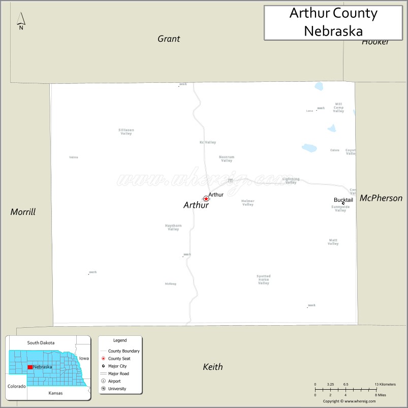
About Arthur County Map, Nebraska: The map showing the county boundary, county seat, major cities, highways, water bodies and neighbouring counties.
Related Nebraska Maps & Info
Map of Arthur County, Nebraska
Arthur County is a county located in the U.S. state of Nebraska. It's county seat is Arthur. As per 2020 census, the population of Arthur County is 439 people and population density is square miles. According to the United States Census Bureau, the county has a total area of 715 sq mi (1,852 km2). Arthur County was established on 1913.
Arthur County Facts
| Continent | North America |
| Country | United States |
| State | Nebraska |
| County Seat | Arthur |
| Largest City/Town | Arthur |
| Established | 1913 |
| Total Area | 718 sq mi (1,860 sq km) |
| Land Area | 715 sq mi (1,852 sq km) |
| Water Area | 3 sq mi (8 sq km) |
| Population | 434 (Census 2020) |
| Population Density | 0.6 people per sq mi |
| Time Zone | Mountain Time Zone (MT) |
| Major Highways | NE 61, NE 92 |
| Major Rivers | North Platte River watershed nearby |
| Neighboring Counties | Grant County, McPherson County, Logan County, Keith County, Garden County |
| Famous For | Sandhills ranching, rural prairie landscapes, historic cowboy culture, tiny county seat |
| Top Attractions | Arthur Bowring Ranch State Historical Park nearby, Nebraska Sandhills scenery, prairie recreation, ranching heritage |
| Official Website | Official Website |
About Arthur County, Nebraska
Arthur County is located in west-central Nebraska in the United States and was established in 1913. The county seat and only incorporated community is Arthur. The county is known for Nebraska Sandhills ranching, wide-open prairie landscapes, cowboy culture, and peaceful rural scenery.
Cities and Towns in Arthur County, Nebraska
| City/Town | Population (Census 2020) | Latitude & Longitude |
|---|---|---|
| Arthur (county seat) | 117 | 41.5719°N, 101.6927°W |
| Lena community | Small rural community | 41.4550°N, 101.8530°W |
| Tryon nearby | 157 | 41.5533°N, 100.9551°W |
| Hyannis nearby | 165 | 42.0006°N, 101.7610°W |
| Ogallala nearby | 4,822 | 41.1289°N, 101.7196°W |
| Mullen nearby | 491 | 42.0669°N, 101.0432°W |
Golf Courses in Arthur County, Nebraska
| Golf Course | Location | Latitude & Longitude |
|---|---|---|
| Hyannis Long Pine Country Club nearby | Hyannis | 42.0017°N, 101.7598°W |
| Ole's Big Game Steakhouse Golf nearby | Paxton | 41.1242°N, 101.3584°W |
| Ash Hollow Golf Course nearby | Ogallala | 41.1280°N, 101.7338°W |
| Dismal River Club nearby | Mullen | 42.0675°N, 101.0200°W |
Roads and Highways in Arthur County, Nebraska
Major highways connect the county to Nebraska Sandhills ranching communities and regional transportation routes.
- Nebraska Highway 61 - north-south highway through western Nebraska
- Nebraska Highway 92 - scenic east-west route across the Nebraska Sandhills
Neighboring Counties of Arthur County
- Grant County (north)
- McPherson County (east)
- Logan County (southeast)
- Keith County (south)
- Garden County (west)
What Are the Top Attractions in Arthur County, Nebraska
The county offers a mix of Sandhills scenery, ranching heritage, and outdoor recreation opportunities.
- Arthur Bowring Ranch State Historical Park nearby - historic ranch buildings and pioneer history
- Nebraska Sandhills scenic drives - rolling grass-covered dunes and prairie landscapes
- Prairie recreation and wildlife viewing - peaceful outdoor exploration opportunities
- Historic cowboy and ranching heritage sites - western Nebraska traditions and culture
- Birdwatching and wildlife habitats - prairie birds, deer, and Sandhills ecosystems
- Photography and sunset viewing across the Sandhills - scenic western Nebraska experiences
- Camping and RV opportunities nearby - outdoor recreation destinations
- Fishing and hunting areas nearby - pheasant, deer, and upland game recreation
- Small-town Arthur attractions - local history and community events
- Ranch tours and cattle country scenery - authentic Nebraska ranchland experiences
- Stargazing opportunities - dark skies and wide-open prairie views
- Nearby Ogallala attractions - museums, restaurants, and Lake McConaughy recreation
- Horseback riding opportunities in Sandhills regions - western outdoor adventure
- Regional rodeos and county fairs - celebrating ranching traditions and rural heritage
What Is the Distance from Arthur County to Nearby Cities
The following distances are measured by road (driving).
- Arthur to Ogallala (Keith County), Nebraska - 42 mi (68 km)
- Arthur to North Platte (Lincoln County), Nebraska - 91 mi (146 km)
- Arthur to Scottsbluff (Scotts Bluff County), Nebraska - 126 mi (203 km)
- Arthur to Kearney (Buffalo County), Nebraska - 170 mi (274 km)
- Arthur to Cheyenne (Laramie County), Wyoming - 190 mi (306 km)
- Arthur to Lincoln (Lancaster County), Nebraska - 295 mi (475 km)
- Arthur to Denver (Denver County), Colorado - 250 mi (402 km)
- Arthur to Omaha (Douglas County), Nebraska - 351 mi (565 km)
- Arthur to Rapid City (Pennington County), South Dakota - 282 mi (454 km)
- Arthur to Pierre (Hughes County), South Dakota - 337 mi (542 km)
- Arthur to Casper (Natrona County), Wyoming - 253 mi (407 km)
- Arthur to Sioux Falls (Minnehaha County), South Dakota - 455 mi (732 km)
FAQs about Arthur County
Arthur County is located in west-central Nebraska within the Nebraska Sandhills region.
Arthur County had a population of 434 according to the 2020 United States Census.
Arthur County is known for Sandhills ranching, prairie landscapes, cowboy culture, and rural Nebraska scenery.
The major highways include Nebraska Highway 61 and Nebraska Highway 92.
Popular attractions include Sandhills scenic drives, ranching heritage sites, prairie recreation, and nearby Arthur Bowring Ranch State Historical Park.
References
- QuickFacts - U.S. Census Bureau
- United States Census Bureau
- United States Geological Survey (USGS)
- National Geodetic Survey
- Official Website
- Adams County Map
- Antelope County Map
- Arthur County Map
- Banner County Map
- Blaine County Map
- Boone County Map
- Box Butte County Map
- Boyd County Map
- Brown County Map
- Buffalo County Map
- Burt County Map
- Butler County Map
- Cass County Map
- Cedar County Map
- Chase County Map
- Cherry County Map
- Cheyenne County Map
- Clay County Map
- Colfax County Map
- Cuming County Map
- Custer County Map
- Dakota County Map
- Dawes County Map
- Dawson County Map
- Deuel County Map
- Dixon County Map
- Dodge County Map
- Douglas County Map
- Dundy County Map
- Fillmore County Map
- Franklin County Map
- Frontier County Map
- Furnas County Map
- Gage County Map
- Garden County Map
- Garfield County Map
- Gosper County Map
- Grant County Map
- Greeley County Map
- Hall County Map
- Hamilton County Map
- Harlan County Map
- Hayes County Map
- Hitchcock County Map
- Holt County Map
- Hooker County Map
- Howard County Map
- Jefferson County Map
- Johnson County Map
- Kearney County Map
- Keith County Map
- Keya Paha County Map
- Kimball County Map
- Knox County Map
- Lancaster County Map
- Lincoln County Map
- Logan County Map
- Loup County Map
- McPherson County Map
- Madison County Map
- Merrick County Map
- Morrill County Map
- Nance County Map
- Nemaha County Map
- Nuckolls County Map
- Otoe County Map
- Pawnee County Map
- Perkins County Map
- Phelps County Map
- Pierce County Map
- Platte County Map
- Polk County Map
- Red Willow County Map
- Richardson County Map
- Rock County Map
- Saline County Map
- Sarpy County Map
- Saunders County Map
- Scotts Bluff County Map
- Seward County Map
- Sheridan County Map
- Sherman County Map
- Sioux County Map
- Stanton County Map
- Thayer County Map
- Thomas County Map
- Thurston County Map
- Valley County Map
- Washington County Map
- Wayne County Map
- Webster County Map
- Wheeler County Map
- York County Map
- Alabama Counties
- Alaska boroughs
- Arizona Counties
- Arkansas Counties
- California County Map
- Colorado Counties
- Connecticut Counties
- Delaware Counties
- Florida County Map
- Georgia County Map
- Hawaii Counties
- Idaho Counties
- Illinois Counties
- Indiana Counties
- Iowa Counties
- Kansas Counties
- Kentucky Counties
- Louisiana Counties
- Maine Counties
- Maryland Counties
- Massachusetts Counties
- Michigan County Map
- Minnesota Counties
- Mississippi Counties
- Missouri Counties
- Montana Counties
- Nebraska Counties
- Nevada Counties
- New York Counties
- New Hampshire Counties
- New Jersey Counties
- New Mexico Counties
- North Carolina Counties
- North Dakota Counties
- Ohio County Map
- Oklahoma Counties
- Oregon Counties
- Pennsylvania Counties
- Rhode Island Counties
- South Carolina Counties
- South Dakota Counties
- Map of Tennessee
- Texas County Map
- Utah Counties
- Vermont Counties
- Virginia Counties
- Washington Counties
- West Virginia Counties
- Wisconsin Counties
- Wyoming Counties