Written and Fact-checked by Whereig Editors, Reviewed by Mukesh Kumar| Last Updated On: May 10, 2026
Map of Red Willow County - Red Willow County is a county located in the U.S. state of Nebraska. Red Willow County Map showing cities, highways, important places and water bodies. Get Where is Red Willow County located in the map, major cities in Red Willow county, population, areas, and places of interest.
Map of Red Willow County, Nebraska
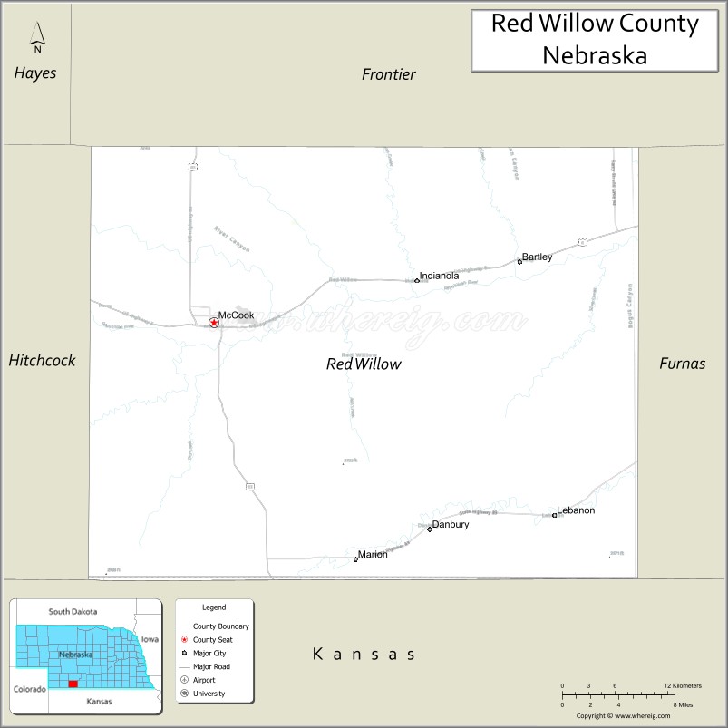
About Red Willow County Map, Nebraska: The map showing the county boundary, county seat, major cities, highways, water bodies and neighbouring counties.
Related Nebraska Maps & Info
Map of Red Willow County, Nebraska
Red Willow County is a county located in the U.S. state of Nebraska. It's county seat is McCook. As per 2020 census, the population of Red Willow County is 10623 people and population density is square miles. According to the United States Census Bureau, the county has a total area of 717 sq mi (1,857 km2). Red Willow County was established on 1873.
Red Willow County Facts
| Continent | North America |
| Country | United States |
| State | Nebraska |
| County Seat | McCook |
| Largest City/Town | McCook |
| Established | 1873 |
| Total Area | 718 sq mi (1,860 sq km) |
| Land Area | 717 sq mi (1,857 sq km) |
| Water Area | 1 sq mi (2.6 sq km) |
| Population | 10,702 (Census 2020) |
| Population Density | 14.9 people per sq mi |
| Time Zone | Central Time Zone |
| Major Highways | U.S. Route 6, U.S. Route 34, U.S. Route 83 |
| Major Rivers | Republican River |
| Neighboring Counties | Frontier County, Furnas County, Hitchcock County, Hayes County, Rawlins County (Kansas) |
| Famous For | McCook heritage, agriculture, and Republican River Valley landscapes |
| Top Attractions | Harvey P. Sutton House, Red Willow State Recreation Area nearby region, and Museum of the High Plains |
| Official Website | Official Website |
About Red Willow County, Nebraska
Red Willow County is located in southwestern Nebraska in the United States and was established in 1873. The county seat is McCook, which is also the largest city in the county. The county is known for agriculture, Republican River Valley scenery, historic railroad heritage, and vibrant regional culture centered around McCook.
Cities and Towns in Red Willow County, Nebraska
| City/Town | Population (Census 2020) | Latitude & Longitude |
|---|---|---|
| McCook (county seat) | 7,446 | 40.2019°N, 100.6268°W |
| Bartley | 283 | 40.2442°N, 100.3076°W |
| Danbury | 94 | 40.0372°N, 100.4179°W |
| Indianola | 584 | 40.2358°N, 100.4182°W |
| Lebanon | 46 | 40.0492°N, 100.2810°W |
Golf Courses in Red Willow County, Nebraska
| Golf Course | Location | Latitude & Longitude |
|---|---|---|
| Heritage Hills Golf Course | McCook | 40.2053°N, 100.6325°W |
| Indianola Country Club | Indianola | 40.2386°N, 100.4227°W |
Roads and Highways in Red Willow County, Nebraska
Major highways connect the county to nearby communities and states.
- U.S. Route 6 - historic east-west highway crossing southern Nebraska
- U.S. Route 34 - major route linking McCook with eastern and western Nebraska regions
- U.S. Route 83 - north-south highway connecting Nebraska with Kansas and South Dakota
Neighboring Counties of Red Willow County
- Frontier County (north)
- Hayes County (west)
- Hitchcock County (southwest)
- Furnas County (east)
- Rawlins County, Kansas (south)
What Are the Top Attractions in Red Willow County, Nebraska
The county offers a mix of historical, cultural, and outdoor attractions.
- Harvey P. Sutton House - Frank Lloyd Wright-designed historic residence in McCook
- Red Willow State Recreation Area Nearby Region - destination for fishing, camping, boating, and hiking
- Museum of the High Plains - exhibits showcasing regional history and pioneer culture
- McCook Downtown Historic District - local shops, restaurants, theaters, and historic architecture
- Republican River Scenic Areas - natural landscapes ideal for wildlife viewing and photography
- Indianola Community Parks - recreation areas with sports facilities and picnic grounds
- Bartley Prairie Landscapes - scenic countryside featuring rolling farmland and prairie views
- Red Willow County Fairgrounds - venue for fairs, rodeos, and community festivals
- Southwestern Nebraska Scenic Drives - countryside routes with High Plains landscapes and open skies
- Outdoor Recreation Areas - hunting, birdwatching, hiking, and nature observation opportunities
What Is the Distance from Red Willow County to Nearby Cities
The following distances are measured by road (driving).
- McCook to North Platte (Lincoln County), Nebraska - 132 mi (212 km)
- McCook to Kearney (Buffalo County), Nebraska - 124 mi (200 km)
- McCook to Hastings (Adams County), Nebraska - 141 mi (227 km)
- McCook to Grand Island (Hall County), Nebraska - 164 mi (264 km)
- McCook to Imperial (Chase County), Nebraska - 49 mi (79 km)
- McCook to Goodland, Kansas - 68 mi (109 km)
- McCook to Denver, Colorado - 268 mi (431 km)
- McCook to Lincoln (Lancaster County), Nebraska - 267 mi (430 km)
- McCook to Omaha (Douglas County), Nebraska - 325 mi (523 km)
- McCook to Wichita, Kansas - 285 mi (459 km)
- McCook to Kansas City, Missouri - 386 mi (621 km)
- McCook to Cheyenne, Wyoming - 290 mi (467 km)
FAQs about Red Willow County
Red Willow County is located in southwestern Nebraska in the United States.
Red Willow County had a population of 10,702 according to Census 2020 data.
Red Willow County is known for McCook heritage, agriculture, and Republican River Valley landscapes.
The county is served by U.S. Route 6, U.S. Route 34, and U.S. Route 83.
Yes, Red Willow County has golf facilities including Heritage Hills Golf Course and Indianola Country Club.
References
- QuickFacts - U.S. Census Bureau
- United States Census Bureau
- United States Geological Survey (USGS)
- National Geodetic Survey
- Official County Website
- Adams County Map
- Antelope County Map
- Arthur County Map
- Banner County Map
- Blaine County Map
- Boone County Map
- Box Butte County Map
- Boyd County Map
- Brown County Map
- Buffalo County Map
- Burt County Map
- Butler County Map
- Cass County Map
- Cedar County Map
- Chase County Map
- Cherry County Map
- Cheyenne County Map
- Clay County Map
- Colfax County Map
- Cuming County Map
- Custer County Map
- Dakota County Map
- Dawes County Map
- Dawson County Map
- Deuel County Map
- Dixon County Map
- Dodge County Map
- Douglas County Map
- Dundy County Map
- Fillmore County Map
- Franklin County Map
- Frontier County Map
- Furnas County Map
- Gage County Map
- Garden County Map
- Garfield County Map
- Gosper County Map
- Grant County Map
- Greeley County Map
- Hall County Map
- Hamilton County Map
- Harlan County Map
- Hayes County Map
- Hitchcock County Map
- Holt County Map
- Hooker County Map
- Howard County Map
- Jefferson County Map
- Johnson County Map
- Kearney County Map
- Keith County Map
- Keya Paha County Map
- Kimball County Map
- Knox County Map
- Lancaster County Map
- Lincoln County Map
- Logan County Map
- Loup County Map
- McPherson County Map
- Madison County Map
- Merrick County Map
- Morrill County Map
- Nance County Map
- Nemaha County Map
- Nuckolls County Map
- Otoe County Map
- Pawnee County Map
- Perkins County Map
- Phelps County Map
- Pierce County Map
- Platte County Map
- Polk County Map
- Red Willow County Map
- Richardson County Map
- Rock County Map
- Saline County Map
- Sarpy County Map
- Saunders County Map
- Scotts Bluff County Map
- Seward County Map
- Sheridan County Map
- Sherman County Map
- Sioux County Map
- Stanton County Map
- Thayer County Map
- Thomas County Map
- Thurston County Map
- Valley County Map
- Washington County Map
- Wayne County Map
- Webster County Map
- Wheeler County Map
- York County Map
- Alabama Counties
- Alaska boroughs
- Arizona Counties
- Arkansas Counties
- California County Map
- Colorado Counties
- Connecticut Counties
- Delaware Counties
- Florida County Map
- Georgia County Map
- Hawaii Counties
- Idaho Counties
- Illinois Counties
- Indiana Counties
- Iowa Counties
- Kansas Counties
- Kentucky Counties
- Louisiana Counties
- Maine Counties
- Maryland Counties
- Massachusetts Counties
- Michigan County Map
- Minnesota Counties
- Mississippi Counties
- Missouri Counties
- Montana Counties
- Nebraska Counties
- Nevada Counties
- New York Counties
- New Hampshire Counties
- New Jersey Counties
- New Mexico Counties
- North Carolina Counties
- North Dakota Counties
- Ohio County Map
- Oklahoma Counties
- Oregon Counties
- Pennsylvania Counties
- Rhode Island Counties
- South Carolina Counties
- South Dakota Counties
- Map of Tennessee
- Texas County Map
- Utah Counties
- Vermont Counties
- Virginia Counties
- Washington Counties
- West Virginia Counties
- Wisconsin Counties
- Wyoming Counties