Written and Fact-checked by Whereig Editors, Reviewed by Mukesh Kumar| Last Updated On: May 10, 2026
Map of Sheridan County - Sheridan County is a county located in the U.S. state of Nebraska. Sheridan County Map showing cities, highways, important places and water bodies. Get Where is Sheridan County located in the map, major cities in Sheridan county, population, areas, and places of interest.
Map of Sheridan County, Nebraska
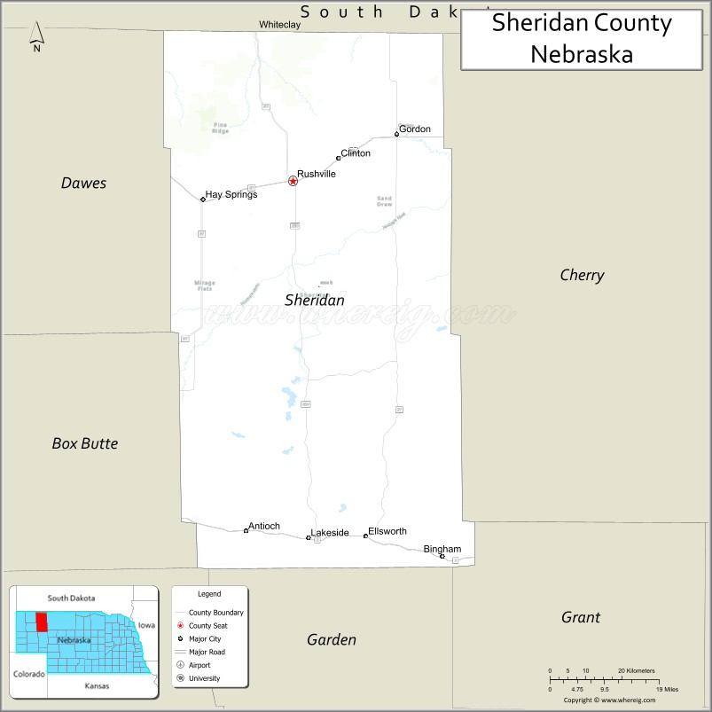
About Sheridan County Map, Nebraska: The map showing the county boundary, county seat, major cities, highways, water bodies and neighbouring counties.
Related Nebraska Maps & Info
Map of Sheridan County, Nebraska
Sheridan County is a county located in the U.S. state of Nebraska. It's county seat is Rushville. As per 2020 census, the population of Sheridan County is 5095 people and population density is square miles. According to the United States Census Bureau, the county has a total area of 2,441 sq mi (6,322 km2). Sheridan County was established on 1885.
Sheridan County Facts
| Continent | North America |
| Country | United States |
| State | Nebraska |
| County Seat | Rushville |
| Largest City/Town | Rushville |
| Established | 1885 |
| Total Area | 2,470 sq mi (6,397 sq km) |
| Land Area | 2,441 sq mi (6,322 sq km) |
| Water Area | 29 sq mi (75 sq km) |
| Population | 4,715 (Census 2020) |
| Population Density | 1.9 people per sq mi |
| Time Zone | Mountain Time Zone |
| Major Highways | U.S. Route 20, Nebraska Highway 27, Nebraska Highway 87 |
| Major Rivers | Niobrara River nearby region |
| Neighboring Counties | Cherry County, Box Butte County, Dawes County, Grant County, Garden County |
| Famous For | Sandhills landscapes, ranching, Pine Ridge scenery, and outdoor recreation |
| Top Attractions | Smith Falls State Park nearby region, Pine Ridge landscapes, and Sheridan County Historical Museum |
| Official Website | Official Website |
About Sheridan County, Nebraska
Sheridan County is located in northwestern Nebraska and was established in 1885. The county seat and largest town is Rushville. The county is known for its expansive Sandhills terrain, ranching heritage, Pine Ridge scenery, and outdoor recreation opportunities throughout western Nebraska.
Cities and Towns in Sheridan County, Nebraska
| City/Town | Population (Census 2020) | Latitude & Longitude |
|---|---|---|
| Rushville (county seat) | 890 | 42.7189°N, 102.4641°W |
| Gordon | 1,478 | 42.8042°N, 102.2032°W |
| Hay Springs | 570 | 42.6836°N, 102.6905°W |
| Lakeside | 21 | 42.0528°N, 102.4433°W |
| Whiteclay | 7 | 42.9994°N, 102.5535°W |
Golf Courses in Sheridan County, Nebraska
| Golf Course | Location | Latitude & Longitude |
|---|---|---|
| Rushville Country Club | Rushville | 42.7234°N, 102.4686°W |
| Gordon Golf Club | Gordon | 42.8088°N, 102.2097°W |
| Hay Springs Golf Course | Hay Springs | 42.6881°N, 102.6960°W |
Roads and Highways in Sheridan County, Nebraska
Major highways connect the county to western Nebraska and South Dakota regions.
- U.S. Route 20 - major east-west highway crossing northern Nebraska
- Nebraska Highway 27 - north-south route serving ranching communities and Sandhills areas
- Nebraska Highway 87 - regional route connecting western Nebraska scenic areas
Neighboring Counties of Sheridan County
- Cherry County (east)
- Grant County (south)
- Garden County (southwest)
- Box Butte County (west)
- Dawes County (northwest)
What Are the Top Attractions in Sheridan County, Nebraska
The county offers a mix of natural, historical, and outdoor attractions.
- Smith Falls State Park Nearby Region - scenic recreation area featuring Nebraska’s tallest waterfall and hiking trails
- Pine Ridge Landscapes - dramatic rock formations, forests, and scenic overlooks in northwestern Nebraska
- Sheridan County Historical Museum - exhibits showcasing ranching heritage and pioneer history
- Sandhills Scenic Drives - countryside routes featuring rolling grasslands and expansive prairie views
- Rushville Downtown District - local shops, restaurants, and historic western Nebraska architecture
- Niobrara River Nearby Recreation Areas - canoeing, fishing, camping, and wildlife observation opportunities
- Gordon Community Parks - recreation areas with sports facilities and family picnic grounds
- Hay Springs Prairie Landscapes - scenic ranchlands ideal for photography and wildlife viewing
- Outdoor Recreation Areas - hunting, hiking, horseback riding, camping, and birdwatching
- Dark Sky Viewing Areas - remote Sandhills locations ideal for astronomy and night photography
What Is the Distance from Sheridan County to Nearby Cities
The following distances are measured by road (driving).
- Rushville to Chadron (Dawes County), Nebraska - 54 mi (87 km)
- Rushville to Alliance (Box Butte County), Nebraska - 67 mi (108 km)
- Rushville to Valentine (Cherry County), Nebraska - 109 mi (175 km)
- Rushville to Scottsbluff (Scotts Bluff County), Nebraska - 117 mi (188 km)
- Rushville to Rapid City, South Dakota - 136 mi (219 km)
- Rushville to Cheyenne, Wyoming - 186 mi (299 km)
- Rushville to Denver, Colorado - 289 mi (465 km)
- Rushville to North Platte (Lincoln County), Nebraska - 208 mi (335 km)
- Rushville to Grand Island (Hall County), Nebraska - 342 mi (550 km)
- Rushville to Kearney (Buffalo County), Nebraska - 282 mi (454 km)
- Rushville to Lincoln (Lancaster County), Nebraska - 471 mi (758 km)
- Rushville to Omaha (Douglas County), Nebraska - 525 mi (845 km)
FAQs about Sheridan County
Sheridan County is located in northwestern Nebraska.
Sheridan County had a population of 4,715 according to Census 2020 data.
Sheridan County is known for Sandhills scenery, ranching, Pine Ridge landscapes, and outdoor recreation.
The county is served by U.S. Route 20, Nebraska Highway 27, and Nebraska Highway 87.
Yes, Sheridan County has golf facilities including Rushville Country Club and Gordon Golf Club.
References
- QuickFacts - U.S. Census Bureau
- United States Census Bureau
- United States Geological Survey (USGS)
- National Park Service
- Official County Website
- Adams County Map
- Antelope County Map
- Arthur County Map
- Banner County Map
- Blaine County Map
- Boone County Map
- Box Butte County Map
- Boyd County Map
- Brown County Map
- Buffalo County Map
- Burt County Map
- Butler County Map
- Cass County Map
- Cedar County Map
- Chase County Map
- Cherry County Map
- Cheyenne County Map
- Clay County Map
- Colfax County Map
- Cuming County Map
- Custer County Map
- Dakota County Map
- Dawes County Map
- Dawson County Map
- Deuel County Map
- Dixon County Map
- Dodge County Map
- Douglas County Map
- Dundy County Map
- Fillmore County Map
- Franklin County Map
- Frontier County Map
- Furnas County Map
- Gage County Map
- Garden County Map
- Garfield County Map
- Gosper County Map
- Grant County Map
- Greeley County Map
- Hall County Map
- Hamilton County Map
- Harlan County Map
- Hayes County Map
- Hitchcock County Map
- Holt County Map
- Hooker County Map
- Howard County Map
- Jefferson County Map
- Johnson County Map
- Kearney County Map
- Keith County Map
- Keya Paha County Map
- Kimball County Map
- Knox County Map
- Lancaster County Map
- Lincoln County Map
- Logan County Map
- Loup County Map
- McPherson County Map
- Madison County Map
- Merrick County Map
- Morrill County Map
- Nance County Map
- Nemaha County Map
- Nuckolls County Map
- Otoe County Map
- Pawnee County Map
- Perkins County Map
- Phelps County Map
- Pierce County Map
- Platte County Map
- Polk County Map
- Red Willow County Map
- Richardson County Map
- Rock County Map
- Saline County Map
- Sarpy County Map
- Saunders County Map
- Scotts Bluff County Map
- Seward County Map
- Sheridan County Map
- Sherman County Map
- Sioux County Map
- Stanton County Map
- Thayer County Map
- Thomas County Map
- Thurston County Map
- Valley County Map
- Washington County Map
- Wayne County Map
- Webster County Map
- Wheeler County Map
- York County Map
- Alabama Counties
- Alaska boroughs
- Arizona Counties
- Arkansas Counties
- California County Map
- Colorado Counties
- Connecticut Counties
- Delaware Counties
- Florida County Map
- Georgia County Map
- Hawaii Counties
- Idaho Counties
- Illinois Counties
- Indiana Counties
- Iowa Counties
- Kansas Counties
- Kentucky Counties
- Louisiana Counties
- Maine Counties
- Maryland Counties
- Massachusetts Counties
- Michigan County Map
- Minnesota Counties
- Mississippi Counties
- Missouri Counties
- Montana Counties
- Nebraska Counties
- Nevada Counties
- New York Counties
- New Hampshire Counties
- New Jersey Counties
- New Mexico Counties
- North Carolina Counties
- North Dakota Counties
- Ohio County Map
- Oklahoma Counties
- Oregon Counties
- Pennsylvania Counties
- Rhode Island Counties
- South Carolina Counties
- South Dakota Counties
- Map of Tennessee
- Texas County Map
- Utah Counties
- Vermont Counties
- Virginia Counties
- Washington Counties
- West Virginia Counties
- Wisconsin Counties
- Wyoming Counties