Written and Fact-checked by Whereig Editors, Reviewed by Mukesh Kumar| Last Updated On: May 10, 2026
Map of Cedar County - Cedar County is a county located in the U.S. state of Nebraska. Cedar County Map showing cities, highways, important places and water bodies. Get Where is Cedar County located in the map, major cities in Cedar county, population, areas, and places of interest.
Map of Cedar County, Nebraska
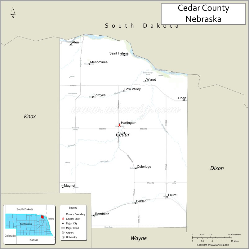
About Cedar County Map, Nebraska: The map showing the county boundary, county seat, major cities, highways, water bodies and neighbouring counties.
Related Nebraska Maps & Info
Map of Cedar County, Nebraska
Cedar County is a county located in the U.S. state of Nebraska. It's county seat is Hartington. As per 2020 census, the population of Cedar County is 8330 people and population density is square miles. According to the United States Census Bureau, the county has a total area of 740 sq mi (1,917 km2). Cedar County was established on 1857.
Cedar County Facts
| Continent | North America |
| Country | United States |
| State | Nebraska |
| County Seat | Hartington |
| Largest City/Town | Hartington |
| Established | 1857 |
| Total Area | 746 sq mi (1,932 sq km) |
| Land Area | 740 sq mi (1,917 sq km) |
| Water Area | 6 sq mi (16 sq km) |
| Population | 8,380 (Census 2020) |
| Population Density | 11.3 people per sq mi |
| Time Zone | Central Time Zone (CT) |
| Major Highways | US 81, US 20, NE 12, NE 15 |
| Major Rivers | Missouri River nearby, Bow Creek |
| Neighboring Counties | Dixon County, Knox County, Wayne County, Pierce County, Yankton County (SD), Clay County (SD) |
| Famous For | Agriculture, Czech and German heritage, Lewis and Clark Lake nearby, small-town Nebraska culture |
| Top Attractions | Hartington parks, Lewis and Clark Lake nearby, Bow Valley recreation, Cedar County Fairgrounds |
| Official Website | Official Website |
About Cedar County, Nebraska
Cedar County is located in northeastern Nebraska in the United States and was established in 1857. The county seat and largest city is Hartington. The county is known for agriculture, rich European immigrant heritage, rolling prairie landscapes, and family-friendly outdoor recreation.
Cities and Towns in Cedar County, Nebraska
| City/Town | Population (Census 2020) | Latitude & Longitude |
|---|---|---|
| Hartington (county seat) | 1,554 | 42.6225°N, 97.2648°W |
| Laurel | 986 | 42.4297°N, 97.0892°W |
| Randolph | 924 | 42.3792°N, 97.3564°W |
| Coleridge | 473 | 42.5072°N, 97.2025°W |
| Fordyce | 127 | 42.7278°N, 97.3553°W |
| Wynot | 210 | 42.7408°N, 97.1695°W |
Golf Courses in Cedar County, Nebraska
| Golf Course | Location | Latitude & Longitude |
|---|---|---|
| Cedar View Country Club | Hartington | 42.6268°N, 97.2727°W |
| Hartington Golf Course | Hartington | 42.6197°N, 97.2608°W |
| Hillcrest Golf & Country Club nearby | Yankton, South Dakota | 42.8795°N, 97.3972°W |
| Norfolk Country Club nearby | Norfolk | 42.0222°N, 97.4304°W |
Roads and Highways in Cedar County, Nebraska
Major highways connect the county to northeastern Nebraska communities and regional recreation destinations.
- US Highway 81 - major north-south highway through Nebraska
- US Highway 20 - important east-west transportation corridor
- Nebraska Highway 12 - scenic route near the Missouri River region
- Nebraska Highway 15 - regional roadway connecting local communities
Neighboring Counties of Cedar County
- Dixon County (east)
- Knox County (west)
- Wayne County (southwest)
- Pierce County (south)
- Yankton County, South Dakota (north)
- Clay County, South Dakota (northeast)
What Are the Top Attractions in Cedar County, Nebraska
The county offers a mix of prairie recreation, cultural heritage, and outdoor activities.
- Hartington parks and recreation areas - walking trails, sports facilities, and family-friendly activities
- Lewis and Clark Lake nearby - boating, fishing, camping, and water recreation
- Bow Valley scenic drives - rolling farmland and northeastern Nebraska landscapes
- Cedar County Fairgrounds - annual fairs, rodeos, and community events
- Cedar View Country Club - golf and recreation opportunities
- Historic churches and immigrant heritage sites - reflecting Czech and German settlement traditions
- Birdwatching and wildlife habitats - prairie ecosystems and migratory birds
- Fishing and hunting opportunities - pheasant, deer, turkey, and waterfowl recreation
- Camping and RV parks nearby - outdoor recreation destinations
- Photography and sunset viewing across Nebraska prairies - scenic countryside experiences
- Historic downtown Hartington - local restaurants, shops, and community events
- Regional festivals and cultural celebrations - honoring local heritage and traditions
- Missouri River recreation nearby - kayaking, boating, and scenic outdoor activities
- Nearby Yankton attractions - museums, parks, shopping, and entertainment venues
What Is the Distance from Cedar County to Nearby Cities
The following distances are measured by road (driving).
- Hartington to Yankton (Yankton County), South Dakota - 28 mi (45 km)
- Hartington to Norfolk (Madison County), Nebraska - 41 mi (66 km)
- Hartington to Sioux City (Woodbury County), Iowa - 74 mi (119 km)
- Hartington to Sioux Falls (Minnehaha County), South Dakota - 86 mi (138 km)
- Hartington to Columbus (Platte County), Nebraska - 117 mi (188 km)
- Hartington to Omaha (Douglas County), Nebraska - 150 mi (241 km)
- Hartington to Lincoln (Lancaster County), Nebraska - 169 mi (272 km)
- Hartington to Pierre (Hughes County), South Dakota - 247 mi (398 km)
- Hartington to Des Moines (Polk County), Iowa - 269 mi (433 km)
- Hartington to Kansas City (Jackson County), Missouri - 324 mi (521 km)
- Hartington to Minneapolis (Hennepin County), Minnesota - 325 mi (523 km)
- Hartington to Denver (Denver County), Colorado - 540 mi (869 km)
FAQs about Cedar County
Cedar County is located in northeastern Nebraska near the South Dakota border.
Cedar County had a population of 8,380 according to the 2020 United States Census.
Cedar County is known for agriculture, Czech and German heritage, prairie recreation, and nearby Missouri River attractions.
The major highways include US Highway 81, US Highway 20, Nebraska Highway 12, and Nebraska Highway 15.
Popular attractions include Lewis and Clark Lake nearby, Cedar County Fairgrounds, Hartington recreation areas, and scenic prairie drives.
References
- QuickFacts - U.S. Census Bureau
- United States Census Bureau
- United States Geological Survey (USGS)
- National Geodetic Survey
- Official Website
- Adams County Map
- Antelope County Map
- Arthur County Map
- Banner County Map
- Blaine County Map
- Boone County Map
- Box Butte County Map
- Boyd County Map
- Brown County Map
- Buffalo County Map
- Burt County Map
- Butler County Map
- Cass County Map
- Cedar County Map
- Chase County Map
- Cherry County Map
- Cheyenne County Map
- Clay County Map
- Colfax County Map
- Cuming County Map
- Custer County Map
- Dakota County Map
- Dawes County Map
- Dawson County Map
- Deuel County Map
- Dixon County Map
- Dodge County Map
- Douglas County Map
- Dundy County Map
- Fillmore County Map
- Franklin County Map
- Frontier County Map
- Furnas County Map
- Gage County Map
- Garden County Map
- Garfield County Map
- Gosper County Map
- Grant County Map
- Greeley County Map
- Hall County Map
- Hamilton County Map
- Harlan County Map
- Hayes County Map
- Hitchcock County Map
- Holt County Map
- Hooker County Map
- Howard County Map
- Jefferson County Map
- Johnson County Map
- Kearney County Map
- Keith County Map
- Keya Paha County Map
- Kimball County Map
- Knox County Map
- Lancaster County Map
- Lincoln County Map
- Logan County Map
- Loup County Map
- McPherson County Map
- Madison County Map
- Merrick County Map
- Morrill County Map
- Nance County Map
- Nemaha County Map
- Nuckolls County Map
- Otoe County Map
- Pawnee County Map
- Perkins County Map
- Phelps County Map
- Pierce County Map
- Platte County Map
- Polk County Map
- Red Willow County Map
- Richardson County Map
- Rock County Map
- Saline County Map
- Sarpy County Map
- Saunders County Map
- Scotts Bluff County Map
- Seward County Map
- Sheridan County Map
- Sherman County Map
- Sioux County Map
- Stanton County Map
- Thayer County Map
- Thomas County Map
- Thurston County Map
- Valley County Map
- Washington County Map
- Wayne County Map
- Webster County Map
- Wheeler County Map
- York County Map
- Alabama Counties
- Alaska boroughs
- Arizona Counties
- Arkansas Counties
- California County Map
- Colorado Counties
- Connecticut Counties
- Delaware Counties
- Florida County Map
- Georgia County Map
- Hawaii Counties
- Idaho Counties
- Illinois Counties
- Indiana Counties
- Iowa Counties
- Kansas Counties
- Kentucky Counties
- Louisiana Counties
- Maine Counties
- Maryland Counties
- Massachusetts Counties
- Michigan County Map
- Minnesota Counties
- Mississippi Counties
- Missouri Counties
- Montana Counties
- Nebraska Counties
- Nevada Counties
- New York Counties
- New Hampshire Counties
- New Jersey Counties
- New Mexico Counties
- North Carolina Counties
- North Dakota Counties
- Ohio County Map
- Oklahoma Counties
- Oregon Counties
- Pennsylvania Counties
- Rhode Island Counties
- South Carolina Counties
- South Dakota Counties
- Map of Tennessee
- Texas County Map
- Utah Counties
- Vermont Counties
- Virginia Counties
- Washington Counties
- West Virginia Counties
- Wisconsin Counties
- Wyoming Counties