Written and Fact-checked by Whereig Editors, Reviewed by Mukesh Kumar| Last Updated On: May 10, 2026
Map of Webster County - Webster County is a county located in the U.S. state of Nebraska. Webster County Map showing cities, highways, important places and water bodies. Get Where is Webster County located in the map, major cities in Webster county, population, areas, and places of interest.
Map of Webster County, Nebraska
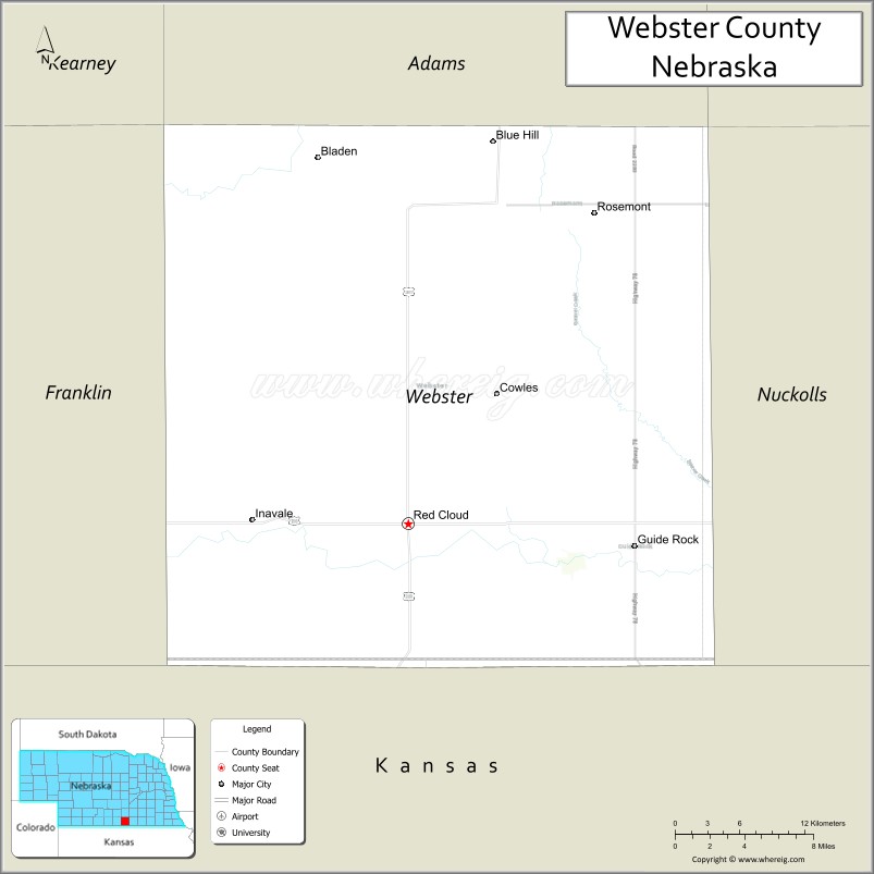
About Webster County Map, Nebraska: The map showing the county boundary, county seat, major cities, highways, water bodies and neighbouring counties.
Related Nebraska Maps & Info
Map of Webster County, Nebraska
Webster County is a county located in the U.S. state of Nebraska. It's county seat is Red Cloud. As per 2020 census, the population of Webster County is 3411 people and population density is square miles. According to the United States Census Bureau, the county has a total area of 575 sq mi (1,489 km2). Webster County was established on 1867.
Webster County Facts
| Continent | North America |
| Country | United States |
| State | Nebraska |
| County Seat | Red Cloud |
| Largest City/Town | Red Cloud |
| Established | 1871 |
| Total Area | 575 sq mi (1,489 sq km) |
| Land Area | 575 sq mi (1,489 sq km) |
| Water Area | 0.4 sq mi (1 sq km) |
| Population | 3,378 (Census 2020) |
| Population Density | 5.9 people per sq mi |
| Time Zone | Central Time Zone |
| Major Highways | U.S. Route 136, Nebraska Highway 4, Nebraska Highway 78 |
| Major Rivers | Republican River |
| Neighboring Counties | Nuckolls County, Franklin County, Adams County, Kearney County, Jewell County (Kansas) |
| Famous For | Author Willa Cather, prairie landscapes, and agricultural heritage |
| Top Attractions | Willa Cather Historic District, National Willa Cather Center, and Republican River recreation areas |
| Official Website | Official Website |
About Webster County, Nebraska
Webster County is located in south-central Nebraska along the Kansas border and was established in 1871. The county seat and largest city is Red Cloud. The county is widely known as the home of Pulitzer Prize-winning author Willa Cather and features scenic prairie landscapes, agricultural communities, and rich literary history.
Cities and Towns in Webster County, Nebraska
| City/Town | Population (Census 2020) | Latitude & Longitude |
|---|---|---|
| Red Cloud (county seat) | 962 | 40.0883°N, 98.5198°W |
| Blue Hill | 915 | 40.3322°N, 98.4481°W |
| Cowles | 22 | 40.2047°N, 98.4495°W |
| Guide Rock | 215 | 40.0736°N, 98.3300°W |
| Inavale | 61 | 40.1050°N, 98.6514°W |
| Rosemont | 18 | 40.3000°N, 98.5575°W |
Golf Courses in Webster County, Nebraska
| Golf Course | Location | Latitude & Longitude |
|---|---|---|
| Red Cloud Golf Club | Red Cloud | 40.0936°N, 98.5254°W |
| Blue Hill Golf Course | Blue Hill | 40.3378°N, 98.4544°W |
Roads and Highways in Webster County, Nebraska
Major highways connect the county to south-central Nebraska and northern Kansas communities.
- U.S. Route 136 - major east-west route serving southern Nebraska communities
- Nebraska Highway 4 - regional highway connecting agricultural and rural areas
- Nebraska Highway 78 - local route linking towns and prairie landscapes
Neighboring Counties of Webster County
- Adams County (north)
- Kearney County (northwest)
- Franklin County (west)
- Nuckolls County (east)
- Jewell County, Kansas (south)
What Are the Top Attractions in Webster County, Nebraska
The county offers a mix of literary, historical, and outdoor attractions.
- Willa Cather Historic District - preserved historic neighborhood connected to the famous American author
- National Willa Cather Center - museum and cultural center dedicated to Willa Cather’s life and works
- Republican River Recreation Areas - scenic locations for fishing, camping, and wildlife viewing
- Red Cloud Opera House - restored historic venue hosting performances and cultural events
- Blue Hill Community Parks - family-friendly recreation spaces and picnic areas
- Prairie Scenic Drives - countryside routes featuring rolling farmland and Great Plains landscapes
- Historic Downtown Red Cloud - local shops, restaurants, and preserved architecture
- Webster County Fairgrounds - venue for fairs, livestock events, rodeos, and festivals
- Outdoor Recreation Areas - hiking, hunting, birdwatching, and photography opportunities
- Literary Heritage Attractions - landmarks and exhibits celebrating Nebraska literary history
What Is the Distance from Webster County to Nearby Cities
The following distances are measured by road (driving).
- Red Cloud to Hastings (Adams County), Nebraska - 52 mi (84 km)
- Red Cloud to Grand Island (Hall County), Nebraska - 92 mi (148 km)
- Red Cloud to Kearney (Buffalo County), Nebraska - 95 mi (153 km)
- Red Cloud to North Platte (Lincoln County), Nebraska - 190 mi (306 km)
- Red Cloud to Lincoln (Lancaster County), Nebraska - 147 mi (237 km)
- Red Cloud to Omaha (Douglas County), Nebraska - 201 mi (323 km)
- Red Cloud to Wichita, Kansas - 207 mi (333 km)
- Red Cloud to Kansas City, Missouri - 236 mi (380 km)
- Red Cloud to Des Moines, Iowa - 287 mi (462 km)
- Red Cloud to Denver, Colorado - 365 mi (587 km)
- Red Cloud to Sioux City, Iowa - 287 mi (462 km)
- Red Cloud to Rapid City, South Dakota - 433 mi (697 km)
FAQs about Webster County
Webster County is located in south-central Nebraska along the Kansas border.
Webster County had a population of 3,378 according to Census 2020 data.
Webster County is known for author Willa Cather, prairie landscapes, and agricultural heritage.
The county is served by U.S. Route 136, Nebraska Highway 4, and Nebraska Highway 78.
Yes, Webster County has golf facilities including Red Cloud Golf Club and Blue Hill Golf Course.
References
- QuickFacts - U.S. Census Bureau
- United States Census Bureau
- United States Geological Survey (USGS)
- Official County Website
- Visit Nebraska
- Adams County Map
- Antelope County Map
- Arthur County Map
- Banner County Map
- Blaine County Map
- Boone County Map
- Box Butte County Map
- Boyd County Map
- Brown County Map
- Buffalo County Map
- Burt County Map
- Butler County Map
- Cass County Map
- Cedar County Map
- Chase County Map
- Cherry County Map
- Cheyenne County Map
- Clay County Map
- Colfax County Map
- Cuming County Map
- Custer County Map
- Dakota County Map
- Dawes County Map
- Dawson County Map
- Deuel County Map
- Dixon County Map
- Dodge County Map
- Douglas County Map
- Dundy County Map
- Fillmore County Map
- Franklin County Map
- Frontier County Map
- Furnas County Map
- Gage County Map
- Garden County Map
- Garfield County Map
- Gosper County Map
- Grant County Map
- Greeley County Map
- Hall County Map
- Hamilton County Map
- Harlan County Map
- Hayes County Map
- Hitchcock County Map
- Holt County Map
- Hooker County Map
- Howard County Map
- Jefferson County Map
- Johnson County Map
- Kearney County Map
- Keith County Map
- Keya Paha County Map
- Kimball County Map
- Knox County Map
- Lancaster County Map
- Lincoln County Map
- Logan County Map
- Loup County Map
- McPherson County Map
- Madison County Map
- Merrick County Map
- Morrill County Map
- Nance County Map
- Nemaha County Map
- Nuckolls County Map
- Otoe County Map
- Pawnee County Map
- Perkins County Map
- Phelps County Map
- Pierce County Map
- Platte County Map
- Polk County Map
- Red Willow County Map
- Richardson County Map
- Rock County Map
- Saline County Map
- Sarpy County Map
- Saunders County Map
- Scotts Bluff County Map
- Seward County Map
- Sheridan County Map
- Sherman County Map
- Sioux County Map
- Stanton County Map
- Thayer County Map
- Thomas County Map
- Thurston County Map
- Valley County Map
- Washington County Map
- Wayne County Map
- Webster County Map
- Wheeler County Map
- York County Map
- Alabama Counties
- Alaska boroughs
- Arizona Counties
- Arkansas Counties
- California County Map
- Colorado Counties
- Connecticut Counties
- Delaware Counties
- Florida County Map
- Georgia County Map
- Hawaii Counties
- Idaho Counties
- Illinois Counties
- Indiana Counties
- Iowa Counties
- Kansas Counties
- Kentucky Counties
- Louisiana Counties
- Maine Counties
- Maryland Counties
- Massachusetts Counties
- Michigan County Map
- Minnesota Counties
- Mississippi Counties
- Missouri Counties
- Montana Counties
- Nebraska Counties
- Nevada Counties
- New York Counties
- New Hampshire Counties
- New Jersey Counties
- New Mexico Counties
- North Carolina Counties
- North Dakota Counties
- Ohio County Map
- Oklahoma Counties
- Oregon Counties
- Pennsylvania Counties
- Rhode Island Counties
- South Carolina Counties
- South Dakota Counties
- Map of Tennessee
- Texas County Map
- Utah Counties
- Vermont Counties
- Virginia Counties
- Washington Counties
- West Virginia Counties
- Wisconsin Counties
- Wyoming Counties