Written and Fact-checked by Whereig Editors, Reviewed by Mukesh Kumar| Last Updated On: May 10, 2026
Map of Seward County - Seward County is a county located in the U.S. state of Nebraska. Seward County Map showing cities, highways, important places and water bodies. Get Where is Seward County located in the map, major cities in Seward county, population, areas, and places of interest.
Map of Seward County, Nebraska
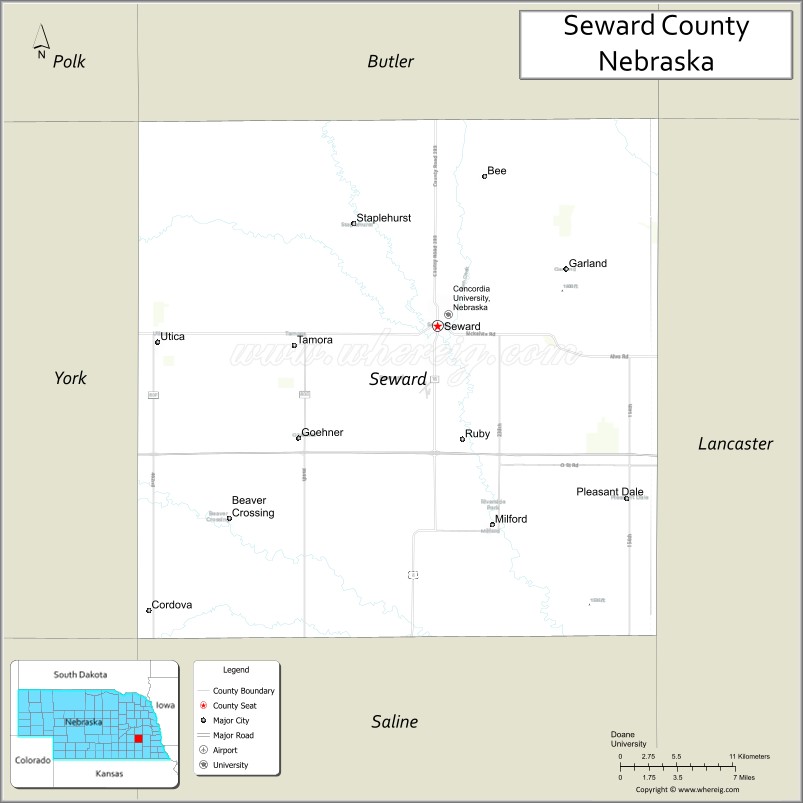
About Seward County Map, Nebraska: The map showing the county boundary, county seat, major cities, highways, water bodies and neighbouring counties.
Related Nebraska Maps & Info
Map of Seward County, Nebraska
Seward County is a county located in the U.S. state of Nebraska. It's county seat is Seward. As per 2020 census, the population of Seward County is 17603 people and population density is square miles. According to the United States Census Bureau, the county has a total area of 575 sq mi (1,489 km2). Seward County was established on 1855.
Seward County Facts
| Continent | North America |
| Country | United States |
| State | Nebraska |
| County Seat | Seward |
| Largest City/Town | Seward |
| Established | 1855 |
| Total Area | 576 sq mi (1,492 sq km) |
| Land Area | 571 sq mi (1,479 sq km) |
| Water Area | 5 sq mi (13 sq km) |
| Population | 17,554 (Census 2020) |
| Population Density | 30.7 people per sq mi |
| Time Zone | Central Time Zone |
| Major Highways | Interstate 80, U.S. Route 34, Nebraska Highway 15 |
| Major Rivers | Big Blue River |
| Neighboring Counties | Butler County, Lancaster County, Saline County, York County, Polk County, Saunders County |
| Famous For | Nebraska’s Fourth of July City, Concordia University, and agriculture |
| Top Attractions | Seward Fourth of July Celebration, Concordia University, and Plum Creek Park |
| Official Website | Official Website |
About Seward County, Nebraska
Seward County is located in southeastern Nebraska in the United States and was established in 1855. The county seat and largest city is Seward. The county is known for its nationally recognized Fourth of July celebration, agricultural economy, educational institutions, and scenic rural landscapes across eastern Nebraska.
Cities and Towns in Seward County, Nebraska
| City/Town | Population (Census 2020) | Latitude & Longitude |
|---|---|---|
| Seward (county seat) | 7,643 | 40.9067°N, 97.0989°W |
| Beaver Crossing | 403 | 40.7772°N, 97.2734°W |
| Cordova | 137 | 40.8864°N, 97.3875°W |
| Garland | 247 | 40.9444°N, 96.9858°W |
| Goehner | 931 | 40.8347°N, 97.2234°W |
| Milford | 2,080 | 40.7747°N, 97.0506°W |
| Pleasant Dale | 205 | 40.7847°N, 96.9300°W |
| Staplehurst | 267 | 40.9997°N, 97.1678°W |
| Tamora | 175 | 40.8981°N, 97.2256°W |
| Utica | 840 | 40.9008°N, 97.3450°W |
Golf Courses in Seward County, Nebraska
| Golf Course | Location | Latitude & Longitude |
|---|---|---|
| Seward Country Club | Seward | 40.9102°N, 97.1056°W |
| Milford Golf Club | Milford | 40.7793°N, 97.0561°W |
| York Country Club Nearby Region | York nearby region | 40.8725°N, 97.5892°W |
Roads and Highways in Seward County, Nebraska
Major highways connect the county to Lincoln, Omaha, and central Nebraska regions.
- Interstate 80 - major east-west interstate corridor across Nebraska
- U.S. Route 34 - important regional highway serving southeastern Nebraska communities
- Nebraska Highway 15 - north-south route connecting Seward County with nearby agricultural areas
Neighboring Counties of Seward County
- Butler County (north)
- Saunders County (northeast)
- Lancaster County (east)
- Saline County (south)
- York County (west)
- Polk County (northwest)
What Are the Top Attractions in Seward County, Nebraska
The county offers a mix of cultural, educational, historical, and outdoor attractions.
- Seward Fourth of July Celebration - nationally recognized Independence Day festival featuring parades, concerts, and fireworks
- Concordia University - historic Lutheran university with cultural events and campus attractions
- Plum Creek Park - recreation area with trails, sports facilities, camping, and picnic grounds
- Seward Downtown Historic District - local shops, restaurants, and historic architecture
- World’s Largest Time Capsule Landmark - famous roadside attraction connected to Seward history
- Milford Community Recreation Areas - parks and family-friendly outdoor spaces
- Big Blue River Scenic Areas - natural landscapes ideal for photography and wildlife observation
- Seward County Fairgrounds - venue for fairs, rodeos, livestock shows, and festivals
- Prairie Scenic Drives - countryside routes featuring farmland and rolling plains
- Outdoor Recreation Trails - hiking, biking, birdwatching, and camping opportunities
What Is the Distance from Seward County to Nearby Cities
The following distances are measured by road (driving).
- Seward to Lincoln (Lancaster County), Nebraska - 25 mi (40 km)
- Seward to York (York County), Nebraska - 28 mi (45 km)
- Seward to Omaha (Douglas County), Nebraska - 82 mi (132 km)
- Seward to Grand Island (Hall County), Nebraska - 82 mi (132 km)
- Seward to Columbus (Platte County), Nebraska - 62 mi (100 km)
- Seward to Kearney (Buffalo County), Nebraska - 122 mi (196 km)
- Seward to Norfolk (Madison County), Nebraska - 108 mi (174 km)
- Seward to North Platte (Lincoln County), Nebraska - 217 mi (349 km)
- Seward to Kansas City, Missouri - 258 mi (415 km)
- Seward to Sioux City, Iowa - 147 mi (237 km)
- Seward to Denver, Colorado - 472 mi (760 km)
- Seward to Des Moines, Iowa - 205 mi (330 km)
FAQs about Seward County
Seward County is located in southeastern Nebraska in the United States.
Seward County had a population of 17,554 according to Census 2020 data.
Seward County is known for Nebraska’s Fourth of July City, Concordia University, and agriculture.
The county is served by Interstate 80, U.S. Route 34, and Nebraska Highway 15.
Yes, Seward County has golf facilities including Seward Country Club and Milford Golf Club.
References
- QuickFacts - U.S. Census Bureau
- United States Census Bureau
- United States Geological Survey (USGS)
- Official County Website
- Visit Seward Nebraska
- Adams County Map
- Antelope County Map
- Arthur County Map
- Banner County Map
- Blaine County Map
- Boone County Map
- Box Butte County Map
- Boyd County Map
- Brown County Map
- Buffalo County Map
- Burt County Map
- Butler County Map
- Cass County Map
- Cedar County Map
- Chase County Map
- Cherry County Map
- Cheyenne County Map
- Clay County Map
- Colfax County Map
- Cuming County Map
- Custer County Map
- Dakota County Map
- Dawes County Map
- Dawson County Map
- Deuel County Map
- Dixon County Map
- Dodge County Map
- Douglas County Map
- Dundy County Map
- Fillmore County Map
- Franklin County Map
- Frontier County Map
- Furnas County Map
- Gage County Map
- Garden County Map
- Garfield County Map
- Gosper County Map
- Grant County Map
- Greeley County Map
- Hall County Map
- Hamilton County Map
- Harlan County Map
- Hayes County Map
- Hitchcock County Map
- Holt County Map
- Hooker County Map
- Howard County Map
- Jefferson County Map
- Johnson County Map
- Kearney County Map
- Keith County Map
- Keya Paha County Map
- Kimball County Map
- Knox County Map
- Lancaster County Map
- Lincoln County Map
- Logan County Map
- Loup County Map
- McPherson County Map
- Madison County Map
- Merrick County Map
- Morrill County Map
- Nance County Map
- Nemaha County Map
- Nuckolls County Map
- Otoe County Map
- Pawnee County Map
- Perkins County Map
- Phelps County Map
- Pierce County Map
- Platte County Map
- Polk County Map
- Red Willow County Map
- Richardson County Map
- Rock County Map
- Saline County Map
- Sarpy County Map
- Saunders County Map
- Scotts Bluff County Map
- Seward County Map
- Sheridan County Map
- Sherman County Map
- Sioux County Map
- Stanton County Map
- Thayer County Map
- Thomas County Map
- Thurston County Map
- Valley County Map
- Washington County Map
- Wayne County Map
- Webster County Map
- Wheeler County Map
- York County Map
- Alabama Counties
- Alaska boroughs
- Arizona Counties
- Arkansas Counties
- California County Map
- Colorado Counties
- Connecticut Counties
- Delaware Counties
- Florida County Map
- Georgia County Map
- Hawaii Counties
- Idaho Counties
- Illinois Counties
- Indiana Counties
- Iowa Counties
- Kansas Counties
- Kentucky Counties
- Louisiana Counties
- Maine Counties
- Maryland Counties
- Massachusetts Counties
- Michigan County Map
- Minnesota Counties
- Mississippi Counties
- Missouri Counties
- Montana Counties
- Nebraska Counties
- Nevada Counties
- New York Counties
- New Hampshire Counties
- New Jersey Counties
- New Mexico Counties
- North Carolina Counties
- North Dakota Counties
- Ohio County Map
- Oklahoma Counties
- Oregon Counties
- Pennsylvania Counties
- Rhode Island Counties
- South Carolina Counties
- South Dakota Counties
- Map of Tennessee
- Texas County Map
- Utah Counties
- Vermont Counties
- Virginia Counties
- Washington Counties
- West Virginia Counties
- Wisconsin Counties
- Wyoming Counties