Written and Fact-checked by Whereig Editors, Reviewed by Mukesh Kumar| Last Updated On: May 10, 2026
Map of Lincoln County - Lincoln County is a county located in the U.S. state of Nebraska. Lincoln County Map showing cities, highways, important places and water bodies. Get Where is Lincoln County located in the map, major cities in Lincoln county, population, areas, and places of interest.
Map of Lincoln County, Nebraska
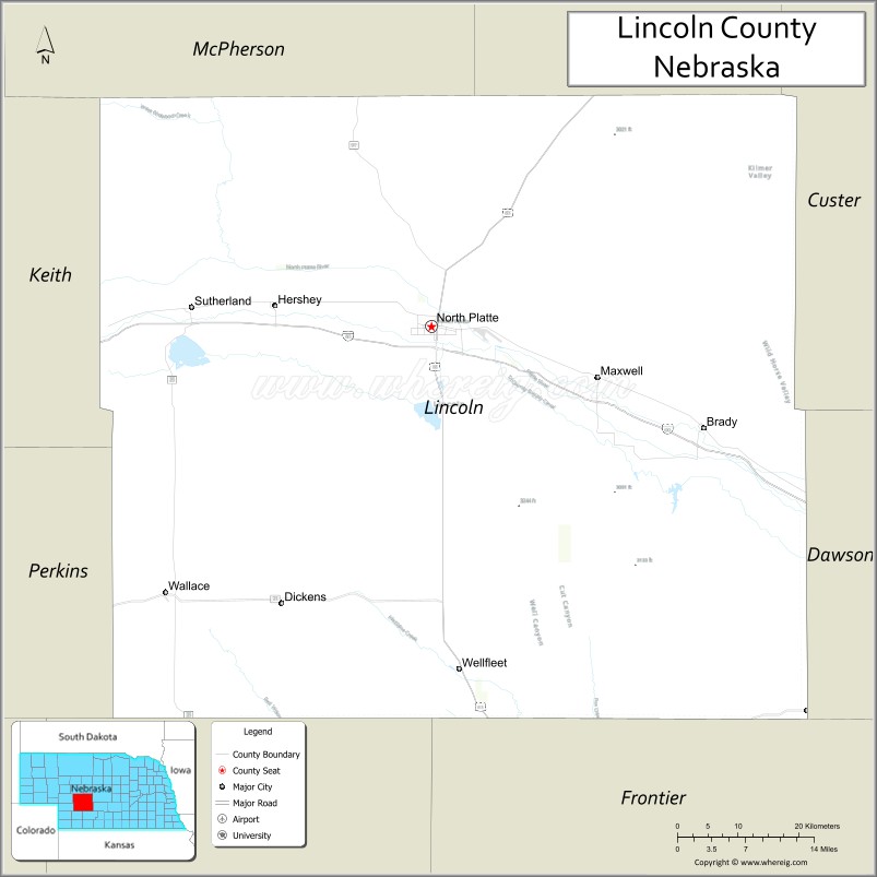
About Lincoln County Map, Nebraska: The map showing the county boundary, county seat, major cities, highways, water bodies and neighbouring counties.
Related Nebraska Maps & Info
Map of Lincoln County, Nebraska
Lincoln County is a county located in the U.S. state of Nebraska. It's county seat is North Platte. As per 2020 census, the population of Lincoln County is 34133 people and population density is square miles. According to the United States Census Bureau, the county has a total area of 2,564 sq mi (6,641 km2). Lincoln County was established on 1860.
Lincoln County Facts
| Continent | North America |
| Country | United States |
| State | Nebraska |
| County Seat | North Platte |
| Largest City/Town | North Platte |
| Established | 1867 |
| Total Area | 2,564 sq mi (6,640 sq km) |
| Land Area | 2,551 sq mi (6,607 sq km) |
| Water Area | 13 sq mi (34 sq km) |
| Population | 34,676 (Census 2020) |
| Population Density | 13.6 people per sq mi |
| Time Zone | Central Time Zone |
| Major Highways | Interstate 80, U.S. Route 30, U.S. Route 83, Nebraska Highway 97 |
| Major Rivers | North Platte River, South Platte River |
| Neighboring Counties | McPherson County, Logan County, Custer County, Dawson County, Frontier County, Hayes County, Keith County |
| Famous For | Buffalo Bill Ranch, Union Pacific rail history, and North Platte |
| Top Attractions | Buffalo Bill Ranch State Historical Park, Golden Spike Tower, and Cody Park |
| Official Website | Official Website |
About Lincoln County, Nebraska
Lincoln County is located in west-central Nebraska in the United States and was established in 1867. The county seat is North Platte, which is also the largest city in the county. The county is known for its railroad heritage, cattle ranching, outdoor recreation, and historic connections to Buffalo Bill Cody and the American West.
Cities and Towns in Lincoln County, Nebraska
| City/Town | Population (Census 2020) | Latitude & Longitude |
|---|---|---|
| North Platte (county seat) | 23,390 | 41.1239°N, 100.7654°W |
| Brady | 428 | 41.0217°N, 100.3671°W |
| Hershey | 665 | 41.1581°N, 101.0029°W |
| Maxwell | 285 | 41.0775°N, 100.5288°W |
| Sutherland | 1,181 | 41.1564°N, 101.1265°W |
| Wallace | 220 | 40.8425°N, 101.1643°W |
| Wellfleet | 72 | 40.7542°N, 100.7276°W |
Golf Courses in Lincoln County, Nebraska
| Golf Course | Location | Latitude & Longitude |
|---|---|---|
| Riverside Golf Club | North Platte | 41.1262°N, 100.7708°W |
| Lake Maloney Golf Club | North Platte | 41.1883°N, 100.7859°W |
| Oregon Trail Golf Course | Sutherland | 41.1592°N, 101.1297°W |
Roads and Highways in Lincoln County, Nebraska
Major highways connect the county to nearby regions and states.
- Interstate 80 - major east-west interstate connecting North Platte with Omaha and Denver
- U.S. Route 30 - historic Lincoln Highway following the Platte River corridor
- U.S. Route 83 - north-south highway linking North Platte with South Dakota and Kansas
- Nebraska Highway 97 - regional route serving Sandhills and western Nebraska communities
Neighboring Counties of Lincoln County
- McPherson County (northwest)
- Logan County (north)
- Custer County (northeast)
- Dawson County (east)
- Frontier County (southeast)
- Hayes County (south)
- Keith County (west)
What Are the Top Attractions in Lincoln County, Nebraska
The county offers a mix of historical, cultural, and outdoor attractions.
- Buffalo Bill Ranch State Historical Park - former home of Buffalo Bill Cody featuring historic buildings and exhibits
- Golden Spike Tower - observation tower overlooking the massive Union Pacific Bailey Yard rail facility
- Cody Park - community park with trails, historic trains, playgrounds, and picnic areas
- Lake Maloney State Recreation Area - boating, fishing, camping, and swimming destination near North Platte
- Bailey Yard - one of the world’s largest railroad classification yards
- Fort Cody Trading Post - roadside attraction featuring Old West exhibits and souvenir shops
- North Platte Area Children's Museum - family attraction with interactive exhibits
- Dust Bowl Brewing and Historic Downtown North Platte - entertainment and dining district
- Platte River Scenic Areas - natural habitats supporting migratory birds and wildlife
- Oregon Trail Historic Routes - regional historical sites connected to westward migration history
What Is the Distance from Lincoln County to Nearby Cities
The following distances are measured by road (driving).
- North Platte to Ogallala (Keith County), Nebraska - 55 mi (89 km)
- North Platte to Kearney (Buffalo County), Nebraska - 100 mi (161 km)
- North Platte to Grand Island (Hall County), Nebraska - 144 mi (232 km)
- North Platte to Scottsbluff (Scotts Bluff County), Nebraska - 112 mi (180 km)
- North Platte to McCook (Red Willow County), Nebraska - 92 mi (148 km)
- North Platte to Broken Bow (Custer County), Nebraska - 84 mi (135 km)
- North Platte to Lexington (Dawson County), Nebraska - 38 mi (61 km)
- North Platte to Lincoln (Lancaster County), Nebraska - 234 mi (377 km)
- North Platte to Omaha (Douglas County), Nebraska - 291 mi (468 km)
- North Platte to Denver, Colorado - 265 mi (426 km)
- North Platte to Cheyenne, Wyoming - 218 mi (351 km)
- North Platte to Rapid City, South Dakota - 287 mi (462 km)
FAQs about Lincoln County
Lincoln County is located in west-central Nebraska in the United States.
Lincoln County had a population of 34,676 according to Census 2020 data.
Lincoln County is known for railroad history, Buffalo Bill Cody, and the city of North Platte.
The county is served by Interstate 80, U.S. Route 30, U.S. Route 83, and Nebraska Highway 97.
Yes, Lincoln County has golf facilities including Riverside Golf Club and Lake Maloney Golf Club.
References
- QuickFacts - U.S. Census Bureau
- United States Census Bureau
- United States Geological Survey (USGS)
- National Geodetic Survey
- Official County Website
- Adams County Map
- Antelope County Map
- Arthur County Map
- Banner County Map
- Blaine County Map
- Boone County Map
- Box Butte County Map
- Boyd County Map
- Brown County Map
- Buffalo County Map
- Burt County Map
- Butler County Map
- Cass County Map
- Cedar County Map
- Chase County Map
- Cherry County Map
- Cheyenne County Map
- Clay County Map
- Colfax County Map
- Cuming County Map
- Custer County Map
- Dakota County Map
- Dawes County Map
- Dawson County Map
- Deuel County Map
- Dixon County Map
- Dodge County Map
- Douglas County Map
- Dundy County Map
- Fillmore County Map
- Franklin County Map
- Frontier County Map
- Furnas County Map
- Gage County Map
- Garden County Map
- Garfield County Map
- Gosper County Map
- Grant County Map
- Greeley County Map
- Hall County Map
- Hamilton County Map
- Harlan County Map
- Hayes County Map
- Hitchcock County Map
- Holt County Map
- Hooker County Map
- Howard County Map
- Jefferson County Map
- Johnson County Map
- Kearney County Map
- Keith County Map
- Keya Paha County Map
- Kimball County Map
- Knox County Map
- Lancaster County Map
- Lincoln County Map
- Logan County Map
- Loup County Map
- McPherson County Map
- Madison County Map
- Merrick County Map
- Morrill County Map
- Nance County Map
- Nemaha County Map
- Nuckolls County Map
- Otoe County Map
- Pawnee County Map
- Perkins County Map
- Phelps County Map
- Pierce County Map
- Platte County Map
- Polk County Map
- Red Willow County Map
- Richardson County Map
- Rock County Map
- Saline County Map
- Sarpy County Map
- Saunders County Map
- Scotts Bluff County Map
- Seward County Map
- Sheridan County Map
- Sherman County Map
- Sioux County Map
- Stanton County Map
- Thayer County Map
- Thomas County Map
- Thurston County Map
- Valley County Map
- Washington County Map
- Wayne County Map
- Webster County Map
- Wheeler County Map
- York County Map
- Alabama Counties
- Alaska boroughs
- Arizona Counties
- Arkansas Counties
- California County Map
- Colorado Counties
- Connecticut Counties
- Delaware Counties
- Florida County Map
- Georgia County Map
- Hawaii Counties
- Idaho Counties
- Illinois Counties
- Indiana Counties
- Iowa Counties
- Kansas Counties
- Kentucky Counties
- Louisiana Counties
- Maine Counties
- Maryland Counties
- Massachusetts Counties
- Michigan County Map
- Minnesota Counties
- Mississippi Counties
- Missouri Counties
- Montana Counties
- Nebraska Counties
- Nevada Counties
- New York Counties
- New Hampshire Counties
- New Jersey Counties
- New Mexico Counties
- North Carolina Counties
- North Dakota Counties
- Ohio County Map
- Oklahoma Counties
- Oregon Counties
- Pennsylvania Counties
- Rhode Island Counties
- South Carolina Counties
- South Dakota Counties
- Map of Tennessee
- Texas County Map
- Utah Counties
- Vermont Counties
- Virginia Counties
- Washington Counties
- West Virginia Counties
- Wisconsin Counties
- Wyoming Counties