Written and Fact-checked by Whereig Editors, Reviewed by Mukesh Kumar| Last Updated On: May 10, 2026
Map of Dawes County - Dawes County is a county located in the U.S. state of Nebraska. Dawes County Map showing cities, highways, important places and water bodies. Get Where is Dawes County located in the map, major cities in Dawes county, population, areas, and places of interest.
Map of Dawes County, Nebraska
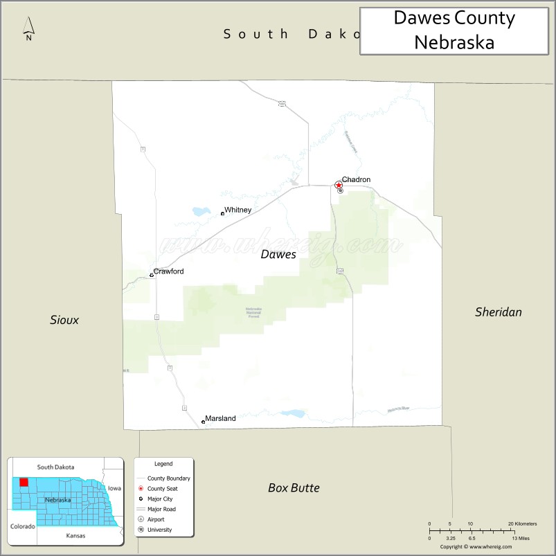
About Dawes County Map, Nebraska: The map showing the county boundary, county seat, major cities, highways, water bodies and neighbouring counties.
Related Nebraska Maps & Info
Map of Dawes County, Nebraska
Dawes County is a county located in the U.S. state of Nebraska. It's county seat is Chadron. As per 2020 census, the population of Dawes County is 8148 people and population density is square miles. According to the United States Census Bureau, the county has a total area of 1,396 sq mi (3,616 km2). Dawes County was established on 1885.
Dawes County Facts
| Continent | North America |
| Country | United States |
| State | Nebraska |
| County Seat | Chadron |
| Largest City/Town | Chadron |
| Established | 1885 |
| Total Area | 1,401 sq mi (3,629 sq km) |
| Land Area | 1,396 sq mi (3,616 sq km) |
| Water Area | 5 sq mi (13 sq km) |
| Population | 8,199 (Census 2020) |
| Population Density | 5.9 people per sq mi |
| Time Zone | Mountain Time Zone (MT) |
| Major Highways | US 20, US 385, NE 2 |
| Major Rivers | White River, Chadron Creek |
| Neighboring Counties | Sheridan County, Sioux County, Box Butte County, Oglala Lakota County (SD), Fall River County (SD) |
| Famous For | Chadron State Park, Pine Ridge region, Chadron State College, outdoor recreation |
| Top Attractions | Chadron State Park, Museum of the Fur Trade nearby, Pine Ridge scenery, Chadron attractions |
| Official Website | Official Website |
About Dawes County, Nebraska
Dawes County is located in northwestern Nebraska in the United States and was established in 1885. The county seat and largest city is Chadron. The county is known for Pine Ridge landscapes, outdoor recreation, western history, and the educational presence of Chadron State College.
Cities and Towns in Dawes County, Nebraska
| City/Town | Population (Census 2020) | Latitude & Longitude |
|---|---|---|
| Chadron (county seat) | 5,206 | 42.8294°N, 103.0008°W |
| Crawford | 997 | 42.6831°N, 103.4124°W |
| Whitney | 77 | 42.8044°N, 103.2797°W |
| Marsland | Small rural community | 42.8136°N, 103.9087°W |
| Chadron State College area | Educational district | 42.8209°N, 103.0037°W |
| Fort Robinson nearby | Historic area | 42.6725°N, 103.4670°W |
Golf Courses in Dawes County, Nebraska
| Golf Course | Location | Latitude & Longitude |
|---|---|---|
| Ridgeview Country Club | Chadron | 42.8355°N, 103.0118°W |
| Table Creek Golf Course | Crawford | 42.6897°N, 103.4215°W |
| The Golf Club at Red Rock nearby | Rapid City, South Dakota | 44.0705°N, 103.2504°W |
| Monument Shadows Golf Course nearby | Gering | 41.8222°N, 103.6642°W |
Roads and Highways in Dawes County, Nebraska
Major highways connect the county to northwestern Nebraska communities and regional recreation destinations.
- US Highway 20 - major east-west highway across northern Nebraska
- US Highway 385 - important north-south transportation route
- Nebraska Highway 2 - scenic route through the Sandhills and Pine Ridge region
Neighboring Counties of Dawes County
- Oglala Lakota County, South Dakota (north)
- Fall River County, South Dakota (northwest)
- Sioux County (west)
- Box Butte County (south)
- Sheridan County (east)
What Are the Top Attractions in Dawes County, Nebraska
The county offers a spectacular mix of Pine Ridge scenery, western history, and outdoor recreation.
- Chadron State Park - hiking, camping, horseback riding, and scenic Pine Ridge recreation
- Museum of the Fur Trade nearby - exhibits on frontier trade and western history
- Pine Ridge scenic drives - dramatic cliffs, forests, and canyon landscapes
- Chadron attractions - restaurants, museums, shopping, and community events
- Fort Robinson State Park nearby - historic military fort and outdoor recreation destination
- Ridgeview Country Club - golf and recreation opportunities
- Birdwatching and wildlife habitats - pine forests, prairie ecosystems, and migratory birds
- Fishing and hunting opportunities - deer, turkey, trout, and upland game recreation
- Camping and RV parks throughout the county - outdoor recreation destinations
- Photography and sunset viewing across the Pine Ridge region - scenic Nebraska experiences
- Historic frontier and railroad heritage attractions - western settlement history
- Horseback riding and trail adventures - exploring Pine Ridge landscapes
- Dark sky stargazing - clear night skies over northwestern Nebraska
- Nearby Black Hills attractions - additional recreation and tourism destinations in South Dakota
What Is the Distance from Dawes County to Nearby Cities
The following distances are measured by road (driving).
- Chadron to Rapid City (Pennington County), South Dakota - 103 mi (166 km)
- Chadron to Scottsbluff (Scotts Bluff County), Nebraska - 108 mi (174 km)
- Chadron to Alliance (Box Butte County), Nebraska - 53 mi (85 km)
- Chadron to Casper (Natrona County), Wyoming - 177 mi (285 km)
- Chadron to Pierre (Hughes County), South Dakota - 219 mi (352 km)
- Chadron to North Platte (Lincoln County), Nebraska - 236 mi (380 km)
- Chadron to Denver (Denver County), Colorado - 300 mi (483 km)
- Chadron to Sioux Falls (Minnehaha County), South Dakota - 412 mi (663 km)
- Chadron to Lincoln (Lancaster County), Nebraska - 436 mi (702 km)
- Chadron to Omaha (Douglas County), Nebraska - 492 mi (792 km)
- Chadron to Billings (Yellowstone County), Montana - 350 mi (563 km)
- Chadron to Minneapolis (Hennepin County), Minnesota - 600 mi (966 km)
FAQs about Dawes County
Dawes County is located in northwestern Nebraska near the South Dakota border.
Dawes County had a population of 8,199 according to the 2020 United States Census.
Dawes County is known for Chadron State Park, Pine Ridge scenery, western history, and outdoor recreation.
The major highways include US Highway 20, US Highway 385, and Nebraska Highway 2.
Popular attractions include Chadron State Park, the Museum of the Fur Trade nearby, Pine Ridge scenic drives, and Fort Robinson State Park nearby.
References
- QuickFacts - U.S. Census Bureau
- United States Census Bureau
- United States Geological Survey (USGS)
- National Geodetic Survey
- Official Website
- Adams County Map
- Antelope County Map
- Arthur County Map
- Banner County Map
- Blaine County Map
- Boone County Map
- Box Butte County Map
- Boyd County Map
- Brown County Map
- Buffalo County Map
- Burt County Map
- Butler County Map
- Cass County Map
- Cedar County Map
- Chase County Map
- Cherry County Map
- Cheyenne County Map
- Clay County Map
- Colfax County Map
- Cuming County Map
- Custer County Map
- Dakota County Map
- Dawes County Map
- Dawson County Map
- Deuel County Map
- Dixon County Map
- Dodge County Map
- Douglas County Map
- Dundy County Map
- Fillmore County Map
- Franklin County Map
- Frontier County Map
- Furnas County Map
- Gage County Map
- Garden County Map
- Garfield County Map
- Gosper County Map
- Grant County Map
- Greeley County Map
- Hall County Map
- Hamilton County Map
- Harlan County Map
- Hayes County Map
- Hitchcock County Map
- Holt County Map
- Hooker County Map
- Howard County Map
- Jefferson County Map
- Johnson County Map
- Kearney County Map
- Keith County Map
- Keya Paha County Map
- Kimball County Map
- Knox County Map
- Lancaster County Map
- Lincoln County Map
- Logan County Map
- Loup County Map
- McPherson County Map
- Madison County Map
- Merrick County Map
- Morrill County Map
- Nance County Map
- Nemaha County Map
- Nuckolls County Map
- Otoe County Map
- Pawnee County Map
- Perkins County Map
- Phelps County Map
- Pierce County Map
- Platte County Map
- Polk County Map
- Red Willow County Map
- Richardson County Map
- Rock County Map
- Saline County Map
- Sarpy County Map
- Saunders County Map
- Scotts Bluff County Map
- Seward County Map
- Sheridan County Map
- Sherman County Map
- Sioux County Map
- Stanton County Map
- Thayer County Map
- Thomas County Map
- Thurston County Map
- Valley County Map
- Washington County Map
- Wayne County Map
- Webster County Map
- Wheeler County Map
- York County Map
- Alabama Counties
- Alaska boroughs
- Arizona Counties
- Arkansas Counties
- California County Map
- Colorado Counties
- Connecticut Counties
- Delaware Counties
- Florida County Map
- Georgia County Map
- Hawaii Counties
- Idaho Counties
- Illinois Counties
- Indiana Counties
- Iowa Counties
- Kansas Counties
- Kentucky Counties
- Louisiana Counties
- Maine Counties
- Maryland Counties
- Massachusetts Counties
- Michigan County Map
- Minnesota Counties
- Mississippi Counties
- Missouri Counties
- Montana Counties
- Nebraska Counties
- Nevada Counties
- New York Counties
- New Hampshire Counties
- New Jersey Counties
- New Mexico Counties
- North Carolina Counties
- North Dakota Counties
- Ohio County Map
- Oklahoma Counties
- Oregon Counties
- Pennsylvania Counties
- Rhode Island Counties
- South Carolina Counties
- South Dakota Counties
- Map of Tennessee
- Texas County Map
- Utah Counties
- Vermont Counties
- Virginia Counties
- Washington Counties
- West Virginia Counties
- Wisconsin Counties
- Wyoming Counties