
Connell is a small city in southeastern Washington, surrounded by the open farmland of the Columbia Basin. It is about 35 miles north of Pasco and is known for its farming community, wide rural landscape, and location near the Snake and Columbia river systems.
Location Map of Connell, Franklin County, Washington
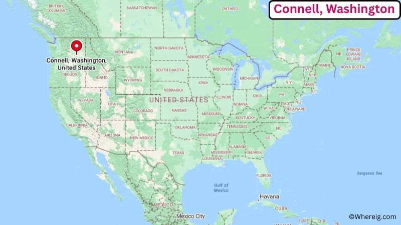
About Map: The map shows the location of Connell in Franklin County, in the U.S. state of Washington.
Connell Map, Washington
About Connell Map: The Google Map highlights the location of Connell in Franklin County, Washington. Use the zoom, satellite, and street-view options to explore the city's neighborhoods, roads, and nearby places.
Where is Connell Located?
Connell is a city located in Franklin County, Washington, the United States. It lies about 35 miles north of Pasco and roughly 45 miles north of Kennewick. Connell is located at approximately 46.6635° North latitude and 118.8611° West longitude. The city covers about 2.33 square miles (6.03 sq km) and had 5,531 residents in the 2020 Census. The surrounding Columbia Basin is mostly flat and open, with irrigated farmland, dry hills, and wide views. Connell was established in the late 19th century and incorporated in 1910. The city grew as a railroad and agricultural community and remains closely tied to farming and food processing. Connell is also home to the Coyote Ridge Corrections Center, one of Washington's major correctional facilities. Interstate 395 passes through the area and connects Connell with Pasco, Spokane, and other cities in eastern Washington.
Most Viewed US Maps
| USA Sttae Map | USA Region Map | USA Road Map |
| USA County Map | Where is USA in World Map? | US ZIP Code Map |
| USA Time Zones Map | US State and Capitals Map | USA Physical Map |
Find 4,400+ U.S. Cities by State - Explore Their Locations and Get Detailed Information
Connell City Facts
| City | Connell |
| State | Washington |
| County | Franklin County |
| Country | United States |
| Region | Columbia Basin / Southeastern Washington |
| Incorporated | 1910 |
| Founded | Late 19th century |
| Total Area | 2.33 sq mi (6.03 sq km) |
| Land Area | 2.31 sq mi (5.98 sq km) |
| Water Area | 0.02 sq mi (0.05 sq km) |
| Elevation | About 860 ft (262 m) |
| Population (2023 estimate) | 5,500 |
| Population (2020 Census) | 5,531 |
| Population Density | About 2,394 people per sq mi |
| Time Zone | Pacific Standard Time (PST); Pacific Daylight Time (PDT) |
| ZIP Codes | 99326 |
| Area Code | 509 |
| Major Highways | Interstate 82, Interstate 90, U.S. Route 395, Washington State Route 260 |
| Public Transit | Ben Franklin Transit |
| Major Attractions | Connell City Park, Coyote Ridge Corrections Center area, Columbia Basin farmland, Potholes Reservoir |
| Official Website | https://www.cityofconnell.com/ |
Distance from Connell, WA to Nearby Cities
- Pasco, WA – 35 miles (56 km)
- Richland, WA – 40 miles (64 km)
- Kennewick, WA – 45 miles (72 km)
- Othello, WA – 35 miles (56 km)
- Hermiston, OR – 60 miles (97 km)
- Walla Walla, WA – 75 miles (121 km)
- Warden, WA – 45 miles (72 km)
- Mattawa, WA – 65 miles (105 km)
- Ellensburg, WA – 115 miles (185 km)
- Yakima, WA – 115 miles (185 km)
- Wenatchee, WA – 130 miles (209 km)
- Spokane, WA – 125 miles (201 km)
- Pullman, WA – 120 miles (193 km)
- Lewiston, ID – 150 miles (241 km)
- Seattle, WA – 220 miles (354 km)
- Portland, OR – 215 miles (346 km)
Top Attractions in Connell
- Connell City Park – Local community park with open green space, recreation facilities, picnic areas, and places for families to gather.
- Connell Area Historical Society Museum – Local collection documenting the city's railroad, farming, and community history.
- Columbia Basin – Wide agricultural region surrounding Connell, known for irrigated farms, dry landscapes, and open views.
- Potholes Reservoir – Popular outdoor destination south of Connell with fishing, boating, camping, birdwatching, and sandy shorelines.
- Columbia National Wildlife Refuge – Large protected area with wetlands, lakes, desert habitat, hiking, fishing, and migratory birds.
- Franklin County Historical Society – Regional organization preserving the history and heritage of Franklin County communities.
- Sacajawea State Park – Scenic park near the Tri-Cities where the Snake and Columbia rivers meet, with trails, boating, camping, and historical exhibits.
- Hanford Reach National Monument – Protected Columbia River landscape known for wildlife, hiking, fishing, and broad views of eastern Washington.
Airports Near Connell
- Tri-Cities Airport (PSC) – 40 miles
- Walla Walla Regional Airport (ALW) – 80 miles
- Eastern Oregon Regional Airport (PDT) – 65 miles
- Grant County International Airport (MWH) – 75 miles
- Spokane International Airport (GEG) – 135 miles
Sources:
Population and area data sourced from the United States Census Bureau (2020 Census). General city information referenced from the official City of Connell website and local government records.
Washington Maps and Info
- Where is Auburn
- Where is Bellevue
- Where is Bellingham
- Where is Bothell
- Where is Bremerton
- Where is Burien
- Where is Camas
- Where is Edmonds
- Where is Everett
- Where is Federal Way
- Where is Frederickson
- Where is Graham
- Where is Issaquah
- Where is Kennewick
- Where is Kent
- Where is Kirkland
- Where is Lacey
- Where is Lake Stevens
- Where is Lakewood
- Where is Longview
- Where is Lynnwood
- Where is Maple Valley
- Where is Marysville
- Where is Mill Creek East
- Where is Mount Vernon
- Where is Olympia
- Where is Orchards
- Where is Parkland
- Where is Pasco
- Where is Pullman
- Where is Puyallup
- Where is Redmond
- Where is Renton
- Where is Richland
- Where is Sammamish
- Where is SeaTac
- Where is Shoreline
- Where is South Hill
- Where is Spanaway
- Where is Spokane Valley
- Where is Tacoma
- Where is Tumwater
- Where is University Place
- Where is Vancouver
- Where is Walla Walla
- Where is Wenatchee
- Where is Yakima