Map of Franklin County - Franklin County is a county located in the U.S. state of Washington. Franklin County Map showing cities, highways, important places and water bodies. Get Where is Franklin County located in the map, major cities in Franklin county, population, areas, and places of interest.
Map of Franklin County, Washington
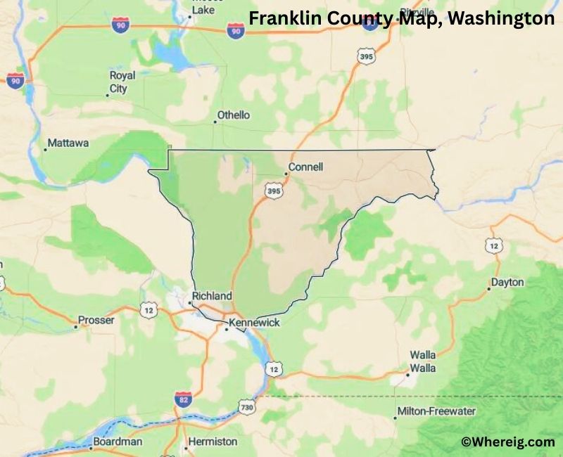
About Franklin County Map, Alabama: The map showing the county boundary, county seat, major cities, highways, water bodies and neighbouring counties.
Most Viewed Links
About Franklin County, Washington
Franklin County is located in the south-central part of Washington, United States. Established in 1883, the county was named after Benjamin Franklin, one of the Founding Fathers of the United States. The county seat and largest city is Pasco, which forms part of the Tri-Cities region along with Kennewick and Richland.
Population
According to the United States Census Bureau, the population of Franklin County was 96,749 as recorded in the 2020 Census. The county has experienced steady growth, largely centered around Pasco and surrounding agricultural communities.
Area and Geography
According to the United States Census Bureau, Franklin County covers a total area of approximately 1,265 square miles, including about 1,242 square miles of land and 23 square miles of water. The county lies within the Columbia Basin and features irrigated farmland, river systems, and semi-arid terrain.
Bordering Counties
Franklin County shares borders with Adams County to the north, Walla Walla County to the southeast, Benton County to the west, and Grant County to the northwest.
Major Cities and Communities
The primary incorporated cities in Franklin County include Pasco, Connell, and Mesa. Pasco serves as the county seat and is a key transportation and economic hub in the region.
Attractions and Recreation
Franklin County offers outdoor recreation along the Columbia and Snake rivers, including boating, fishing, and park facilities. Agricultural tourism and community events also contribute to the county’s local character and economy.
Transportation
Major transportation routes serving Franklin County include Interstate 82, Interstate 182, U.S. Route 395, and State Route 17, connecting the county to other parts of Washington and neighboring states.
Explore more counties in Washington Counties or view the complete USA States Map section for additional geographic information.
Sources:
Population and area data sourced from the United States Census Bureau (2020 Census). General county information referenced from the Official Franklin County Government Website.
Facts about Franklin County, Washington
| Country | United States |
| State | Washington |
| Region | Southeastern Washington |
| County Seat | Pasco |
| Named After | Benjamin Franklin |
| Established | 1883 |
| Organized | 1883 |
| Coordinates | 46.5360° N, 118.9010° W |
| Total Area | 1,243 sq mi |
| Land Area | 1,204 sq mi |
| Water Area | 39 sq mi |
| Population (2020) | 96,749 |
| Population Rank | Mid-sized county in Washington |
| Largest City | Pasco |
| Main Industries | Agriculture, Food Processing, Manufacturing, Transportation |
| Major Highways | Interstate 182, U.S. Route 12, State Route 395 |
| Time Zone | Pacific Time (UTC−08:00) |
| Known For | Columbia Basin agriculture, Tri-Cities region, Columbia River |
| Website | https://www.franklincountywa.gov |
Top Attractions in Franklin County, Washington
- Sacajawea State Park – Columbia River history and trails.
- Columbia River – Boating, fishing, and river views.
- Pasco Waterfront – Riverwalk and scenic access.
- Franklin County Historical Society Museum – Local history exhibits.
- Ed Hendler Bridge – Columbia River crossing views.
- Chiawana Park – Riverfront park and recreation.
- HAPO Center – Events, expos, and fairs.
- Tri-Cities Farmers Market – Local food and vendors.
- Ice Harbor Dam (nearby) – Snake River dam views.
- Broadmoor Park – Community park and sports fields.
- Franklin County Fairgrounds – Annual fair and events.
- Snake River (nearby) – Fishing and scenic shoreline.
Cities & Towns in Franklin County, Washington
Pasco, Connell, Kahlotus, Mesa, Basin City, Franklin County Rural Communities
- Adams County Map, WA
- Asotin County Map, WA
- Benton County Map, WA
- Chelan County Map, WA
- Clallam County Map, WA
- Clark County Map, WA
- Columbia County Map, WA
- Cowlitz County Map, WA
- Douglas County Map, WA
- Ferry County Map, WA
- Franklin County Map, WA
- Garfield County Map, WA
- Grant County Map, WA
- Grays Harbor County Map, WA
- Island County Map, WA
- Jefferson County Map, WA
- King County Map, WA
- Kitsap County Map, WA
- Kittitas County Map, WA
- Klickitat County Map, WA
- Lewis County Map, WA
- Lincoln County Map, WA
- Mason County Map, WA
- Okanogan County Map, WA
- Pacific County Map, WA
- Pend Oreille County Map, WA
- Pierce County Map, WA
- San Juan County Map, WA
- Skagit County Map, WA
- Skamania County Map, WA
- Snohomish County Map, WA
- Spokane County Map, WA
- Stevens County Map, WA
- Thurston County Map, WA
- Wahkiakum County Map, WA
- Walla Walla County Map, WA
- Whatcom County Map, WA
- Whitman County Map, WA
- Yakima County Map, WA
- Alabama Counties
- Alaska boroughs
- Arizona Counties
- Arkansas Counties
- California County Map
- Colorado Counties
- Connecticut Counties
- Delaware Counties
- Florida County Map
- Georgia County Map
- Hawaii Counties
- Idaho Counties
- Illinois Counties
- Indiana Counties
- Iowa Counties
- Kansas Counties
- Kentucky Counties
- Louisiana Counties
- Maine Counties
- Maryland Counties
- Massachusetts Counties
- Michigan County Map
- Minnesota Counties
- Mississippi Counties
- Missouri Counties
- Montana Counties
- Nebraska Counties
- Nevada Counties
- New York Counties
- New Hampshire Counties
- New Jersey Counties
- New Mexico Counties
- North Carolina Counties
- North Dakota Counties
- Ohio County Map
- Oklahoma Counties
- Oregon Counties
- Pennsylvania Counties
- Rhode Island Counties
- South Carolina Counties
- South Dakota Counties
- Map of Tennessee
- Texas County Map
- Utah Counties
- Vermont Counties
- Virginia Counties
- Washington Counties
- West Virginia Counties
- Wisconsin Counties
- Wyoming Counties