Map of Pend Oreille County - Pend Oreille County is a county located in the U.S. state of Washington. Pend Oreille County Map showing cities, highways, important places and water bodies. Get Where is Pend Oreille County located in the map, major cities in Pend Oreille county, population, areas, and places of interest.
Map of Pend Oreille County, Washington
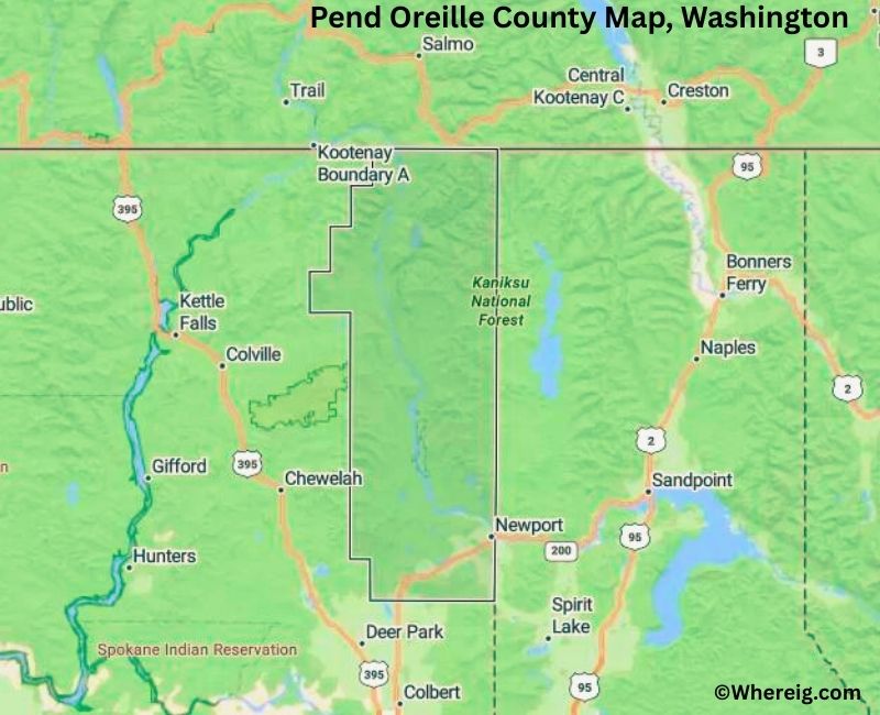
About Pend Oreille County Map, Alabama: The map showing the county boundary, county seat, major cities, highways, water bodies and neighbouring counties.
Most Viewed Links
About Pend Oreille County, Washington
Pend Oreille County is located in the northeastern part of Washington, United States, along the border with Canada. Established in 1911, the county was named after the Pend Oreille River and the Native American tribe of the same name. The county seat and largest city is Newport, which serves as the primary administrative and commercial center of the county.
Population
According to the United States Census Bureau, the population of Pend Oreille County was 13,401 as recorded in the 2020 Census. The county is largely rural, with small communities surrounded by forests, mountains, and waterways.
Area and Geography
According to the United States Census Bureau, Pend Oreille County covers a total area of approximately 1,425 square miles, including about 1,400 square miles of land and 25 square miles of water. The county features forested mountains, river valleys, and scenic lakes characteristic of northeastern Washington.
Bordering Counties
Pend Oreille County shares borders with Stevens County to the west and Spokane County to the south, while its northern boundary meets Canada.
Major Cities and Communities
The principal communities in Pend Oreille County include Newport, Metaline Falls, and Ione. Newport serves as the county seat and a regional center for services and commerce.
Attractions and Recreation
Pend Oreille County offers outdoor recreation opportunities including fishing, boating, hiking, and camping. The Pend Oreille River and surrounding forest lands attract visitors seeking scenic landscapes and nature-based activities throughout the year.
Transportation
Major transportation routes serving Pend Oreille County include U.S. Route 2 and State Route 20, connecting the county to other parts of northeastern Washington.
Explore more counties in Washington Counties or view the complete USA States Map section for additional geographic information.
Sources:
Population and area data sourced from the United States Census Bureau (2020 Census). General county information referenced from the Official Pend Oreille County Government Website.
Facts about Pend Oreille County, Washington
| Country | United States |
| State | Washington |
| Region | Northeastern Washington |
| County Seat | Newport |
| Named After | Pend Oreille River (French for “ear pendant”) |
| Established | 1911 |
| Organized | 1911 |
| Coordinates | 48.5300° N, 117.2700° W |
| Total Area | 1,425 sq mi |
| Land Area | 1,400 sq mi |
| Water Area | 25 sq mi |
| Population (2020) | 13,001 |
| Population Rank | One of the least populous counties in Washington |
| Largest City | Newport |
| Main Industries | Forestry, Agriculture, Tourism, Manufacturing |
| Major Highways | U.S. Route 2, State Route 20 |
| Time Zone | Pacific Time (UTC−08:00) |
| Known For | Selkirk Mountains, Pend Oreille River, Outdoor recreation |
| Website | https://www.pendoreilleco.org |
Top Attractions in Pend Oreille County, Washington
- Metaline Falls Historic District – Small-town charm and views.
- Sweet Creek Falls – Scenic waterfall hike.
- Pend Oreille River – Fishing and river scenery.
- Sullivan Lake State Park – Camping and lakeside recreation.
- Metaline Falls Bigfoot Festival – Local culture and events.
- Lake Box Canyon – Quiet water recreation.
- Boundary Dam Overlook – River and dam views.
- Pend Oreille County Historical Museum – Local history exhibits.
- Mill Pond Historic Site – Early industry remnants.
- Gypsy Peak Wilderness (nearby) – Remote hiking and scenery.
- Metaline Mining District – Historic mining area.
- Scenic Forest Roads – Mountain and river vistas.
Cities & Towns in Pend Oreille County, Washington
Newport, Cusick, Ione, Metaline, Metaline Falls, Usk, Pend Oreille County Rural Communities
- Adams County Map, WA
- Asotin County Map, WA
- Benton County Map, WA
- Chelan County Map, WA
- Clallam County Map, WA
- Clark County Map, WA
- Columbia County Map, WA
- Cowlitz County Map, WA
- Douglas County Map, WA
- Ferry County Map, WA
- Franklin County Map, WA
- Garfield County Map, WA
- Grant County Map, WA
- Grays Harbor County Map, WA
- Island County Map, WA
- Jefferson County Map, WA
- King County Map, WA
- Kitsap County Map, WA
- Kittitas County Map, WA
- Klickitat County Map, WA
- Lewis County Map, WA
- Lincoln County Map, WA
- Mason County Map, WA
- Okanogan County Map, WA
- Pacific County Map, WA
- Pend Oreille County Map, WA
- Pierce County Map, WA
- San Juan County Map, WA
- Skagit County Map, WA
- Skamania County Map, WA
- Snohomish County Map, WA
- Spokane County Map, WA
- Stevens County Map, WA
- Thurston County Map, WA
- Wahkiakum County Map, WA
- Walla Walla County Map, WA
- Whatcom County Map, WA
- Whitman County Map, WA
- Yakima County Map, WA
- Alabama Counties
- Alaska boroughs
- Arizona Counties
- Arkansas Counties
- California County Map
- Colorado Counties
- Connecticut Counties
- Delaware Counties
- Florida County Map
- Georgia County Map
- Hawaii Counties
- Idaho Counties
- Illinois Counties
- Indiana Counties
- Iowa Counties
- Kansas Counties
- Kentucky Counties
- Louisiana Counties
- Maine Counties
- Maryland Counties
- Massachusetts Counties
- Michigan County Map
- Minnesota Counties
- Mississippi Counties
- Missouri Counties
- Montana Counties
- Nebraska Counties
- Nevada Counties
- New York Counties
- New Hampshire Counties
- New Jersey Counties
- New Mexico Counties
- North Carolina Counties
- North Dakota Counties
- Ohio County Map
- Oklahoma Counties
- Oregon Counties
- Pennsylvania Counties
- Rhode Island Counties
- South Carolina Counties
- South Dakota Counties
- Map of Tennessee
- Texas County Map
- Utah Counties
- Vermont Counties
- Virginia Counties
- Washington Counties
- West Virginia Counties
- Wisconsin Counties
- Wyoming Counties