Map of Grays Harbor County - Grays Harbor County is a county located in the U.S. state of Washington. Grays Harbor County Map showing cities, highways, important places and water bodies. Get Where is Grays Harbor County located in the map, major cities in Grays Harbor county, population, areas, and places of interest.
Map of Grays Harbor County, Washington
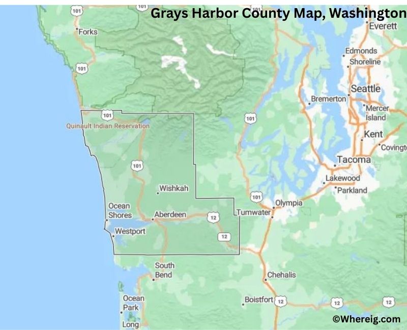
About Grays Harbor County Map, Alabama: The map showing the county boundary, county seat, major cities, highways, water bodies and neighbouring counties.
Most Viewed Links
About Grays Harbor County, Washington
Grays Harbor County is located in the western part of Washington, United States, along the Pacific Ocean. Established in 1854, the county was originally named Chehalis County and later renamed after Grays Harbor, which was named for Captain Robert Gray, an American explorer. The county seat is Montesano, while Aberdeen is the largest city and a historic center for the timber industry.
Population
According to the United States Census Bureau, the population of Grays Harbor County was 75,636 as recorded in the 2020 Census. The county includes coastal communities, small towns, and rural areas, with many residents living in Aberdeen, Hoquiam, and Ocean Shores.
Area and Geography
According to the United States Census Bureau, Grays Harbor County covers a total area of approximately 2,224 square miles, including about 1,902 square miles of land and 322 square miles of water. The county features coastal shorelines, river systems, forested hills, and access to the Pacific coastline.
Bordering Counties
Grays Harbor County shares borders with Jefferson County to the north, Mason County to the northeast, Thurston County to the east, Lewis County to the southeast, and Pacific County to the south.
Major Cities and Communities
The principal cities in Grays Harbor County include Aberdeen, Hoquiam, Montesano, and Ocean Shores. Aberdeen is the largest city and historically known for its timber and maritime industries.
Attractions and Recreation
Grays Harbor County offers coastal recreation, fishing, and beach access along the Pacific Ocean. Ocean Shores is a popular destination for beach activities, while forested areas and river systems provide opportunities for hiking, camping, and wildlife viewing.
Transportation
Major transportation routes serving Grays Harbor County include U.S. Route 101 an
Facts about Grays Harbor County, Washington
| Country | United States |
| State | Washington |
| Region | Southwestern Washington |
| County Seat | Montesano |
| Named After | Grays Harbor (named by Captain Robert Gray) |
| Established | 1854 |
| Organized | 1854 |
| Coordinates | 47.1440° N, 123.8030° W |
| Total Area | 2,224 sq mi |
| Land Area | 1,902 sq mi |
| Water Area | 322 sq mi |
| Population (2020) | 75,636 |
| Population Rank | Mid-sized county in Washington |
| Largest City | Aberdeen |
| Main Industries | Forestry, Fishing, Manufacturing, Tourism |
| Major Highways | U.S. Route 12, U.S. Route 101 |
| Time Zone | Pacific Time (UTC−08:00) |
| Known For | Pacific coastline, Timber industry, Grays Harbor Bay |
| Website | https://www.graysharbor.us |
Top Attractions in Grays Harbor County, Washington
- Olympic National Park (nearby) – Rainforests and mountain scenery.
- Ocean Shores – Beaches and coastal recreation.
- Westport Light State Park – Lighthouse and ocean views.
- Westport Maritime Museum – Coastal and maritime history.
- Grays Harbor National Wildlife Refuge – Shorebirds and wetlands.
- Lake Quinault (nearby) – Scenic lake and rainforest.
- North Jetty (Ocean Shores) – Beach access and fishing.
- Aberdeen Museum of History – Local heritage exhibits.
- Hoquiam Castle – Historic hilltop mansion.
- Bowerman Basin – Birdwatching area.
- Westport Marina – Charter fishing and harbor views.
- Grays Harbor Lighthouse – Tall lighthouse and tours.
Cities & Towns in Grays Harbor County, Washington
Aberdeen, Hoquiam, Ocean Shores, Montesano, Elma, Cosmopolis, Westport, McCleary, Raymond, Humptulips
- Adams County Map, WA
- Asotin County Map, WA
- Benton County Map, WA
- Chelan County Map, WA
- Clallam County Map, WA
- Clark County Map, WA
- Columbia County Map, WA
- Cowlitz County Map, WA
- Douglas County Map, WA
- Ferry County Map, WA
- Franklin County Map, WA
- Garfield County Map, WA
- Grant County Map, WA
- Grays Harbor County Map, WA
- Island County Map, WA
- Jefferson County Map, WA
- King County Map, WA
- Kitsap County Map, WA
- Kittitas County Map, WA
- Klickitat County Map, WA
- Lewis County Map, WA
- Lincoln County Map, WA
- Mason County Map, WA
- Okanogan County Map, WA
- Pacific County Map, WA
- Pend Oreille County Map, WA
- Pierce County Map, WA
- San Juan County Map, WA
- Skagit County Map, WA
- Skamania County Map, WA
- Snohomish County Map, WA
- Spokane County Map, WA
- Stevens County Map, WA
- Thurston County Map, WA
- Wahkiakum County Map, WA
- Walla Walla County Map, WA
- Whatcom County Map, WA
- Whitman County Map, WA
- Yakima County Map, WA
- Alabama Counties
- Alaska boroughs
- Arizona Counties
- Arkansas Counties
- California County Map
- Colorado Counties
- Connecticut Counties
- Delaware Counties
- Florida County Map
- Georgia County Map
- Hawaii Counties
- Idaho Counties
- Illinois Counties
- Indiana Counties
- Iowa Counties
- Kansas Counties
- Kentucky Counties
- Louisiana Counties
- Maine Counties
- Maryland Counties
- Massachusetts Counties
- Michigan County Map
- Minnesota Counties
- Mississippi Counties
- Missouri Counties
- Montana Counties
- Nebraska Counties
- Nevada Counties
- New York Counties
- New Hampshire Counties
- New Jersey Counties
- New Mexico Counties
- North Carolina Counties
- North Dakota Counties
- Ohio County Map
- Oklahoma Counties
- Oregon Counties
- Pennsylvania Counties
- Rhode Island Counties
- South Carolina Counties
- South Dakota Counties
- Map of Tennessee
- Texas County Map
- Utah Counties
- Vermont Counties
- Virginia Counties
- Washington Counties
- West Virginia Counties
- Wisconsin Counties
- Wyoming Counties