Map of Whatcom County - Whatcom County is a county located in the U.S. state of Washington. Whatcom County Map showing cities, highways, important places and water bodies. Get Where is Whatcom County located in the map, major cities in Whatcom county, population, areas, and places of interest.
Map of Whatcom County, Washington
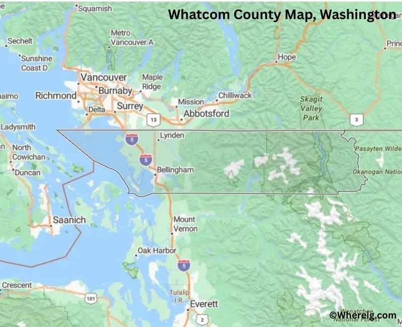
About Whatcom County Map, Alabama: The map showing the county boundary, county seat, major cities, highways, water bodies and neighbouring counties.
Most Viewed Links
About Whatcom County, Washington
Whatcom County is located in the northwestern corner of Washington, United States, along the border with Canada and the coastline of the Salish Sea. Established in 1854, the county was named after the Lummi word meaning "noisy water." The county seat and largest city is Bellingham, which serves as a major cultural, educational, and economic center in the region.
Population
According to the United States Census Bureau, the population of Whatcom County was 226,847 as recorded in the 2020 Census. The county includes urban centers, coastal communities, and rural areas, with most residents living in and around Bellingham.
Area and Geography
According to the United States Census Bureau, Whatcom County covers a total area of approximately 2,503 square miles, including about 2,107 square miles of land and 396 square miles of water. The county features coastal shorelines, mountain ranges, river valleys, and forested terrain extending into the North Cascades.
Bordering Counties
Whatcom County shares borders with Skagit County to the south and Okanogan County to the east, while its northern boundary meets Canada.
Major Cities and Communities
The principal communities in Whatcom County include Bellingham, Ferndale, Lynden, Blaine, and Everson. Bellingham serves as the county seat and is home to Western Washington University.
Attractions and Recreation
Whatcom County offers diverse outdoor recreation including hiking, skiing, boating, and wildlife viewing. The county provides access to North Cascades National Park and scenic coastal areas, attracting visitors throughout the year.
Transportation
Major transportation routes serving Whatcom County include Interstate 5 and State Route 542, connecting the county to Seattle and the Canadian border.
Explore more counties in Washington Counties or view the complete USA States Map section for additional geographic information.
Sources:
Population and area data sourced from the United States Census Bureau (2020 Census). General county information referenced from the Official Whatcom County Government Website.
Facts about Whatcom County, Washington
| Country | United States |
| State | Washington |
| Region | Northwestern Washington |
| County Seat | Bellingham |
| Named After | Whatcom (Native American word meaning “noisy waters”) |
| Established | 1854 |
| Organized | 1854 |
| Coordinates | 48.8280° N, 121.8880° W |
| Total Area | 2,107 sq mi |
| Land Area | 2,103 sq mi |
| Water Area | 4 sq mi |
| Population (2020) | 226,847 |
| Population Rank | Seventh most populous county in Washington |
| Largest City | Bellingham |
| Main Industries | Education, Healthcare, Manufacturing, Tourism, Trade |
| Major Highways | Interstate 5, State Route 542, State Route 539 |
| Time Zone | Pacific Time (UTC−08:00) |
| Known For | Mount Baker, Puget Sound access, Outdoor recreation |
| Website | https://www.whatcomcounty.us |
Top Attractions in Whatcom County, Washington
- Mount Baker – Alpine scenery and skiing.
- North Cascades National Park (nearby) – Mountain hiking and views.
- Bellingham Waterfront – Harbor views and dining.
- Fairhaven Historic District – Shops and Victorian buildings.
- Chuckanut Drive Scenic Byway – Coastal cliffside drive.
- Larrabee State Park – Beaches and forest trails.
- Lake Whatcom – Boating and lakeside recreation.
- Mount Baker Theatre – Historic performing arts venue.
- Peace Arch State Park – U.S.–Canada border landmark.
- Padilla Bay (nearby) – Estuary and wildlife viewing.
- Whatcom Falls Park – Waterfalls and walking paths.
- Marine Life Center (Bellingham) – Marine wildlife education.
Cities & Towns in Whatcom County, Washington
Bellingham, Ferndale, Lynden, Blaine, Sumas, Everson, Nooksack, Maple Falls, Birch Bay, Lummi Island, Kendall, Acme, Custer, Deming, Glacier, Kendall, Sudden Valley
- Adams County Map, WA
- Asotin County Map, WA
- Benton County Map, WA
- Chelan County Map, WA
- Clallam County Map, WA
- Clark County Map, WA
- Columbia County Map, WA
- Cowlitz County Map, WA
- Douglas County Map, WA
- Ferry County Map, WA
- Franklin County Map, WA
- Garfield County Map, WA
- Grant County Map, WA
- Grays Harbor County Map, WA
- Island County Map, WA
- Jefferson County Map, WA
- King County Map, WA
- Kitsap County Map, WA
- Kittitas County Map, WA
- Klickitat County Map, WA
- Lewis County Map, WA
- Lincoln County Map, WA
- Mason County Map, WA
- Okanogan County Map, WA
- Pacific County Map, WA
- Pend Oreille County Map, WA
- Pierce County Map, WA
- San Juan County Map, WA
- Skagit County Map, WA
- Skamania County Map, WA
- Snohomish County Map, WA
- Spokane County Map, WA
- Stevens County Map, WA
- Thurston County Map, WA
- Wahkiakum County Map, WA
- Walla Walla County Map, WA
- Whatcom County Map, WA
- Whitman County Map, WA
- Yakima County Map, WA
- Alabama Counties
- Alaska boroughs
- Arizona Counties
- Arkansas Counties
- California County Map
- Colorado Counties
- Connecticut Counties
- Delaware Counties
- Florida County Map
- Georgia County Map
- Hawaii Counties
- Idaho Counties
- Illinois Counties
- Indiana Counties
- Iowa Counties
- Kansas Counties
- Kentucky Counties
- Louisiana Counties
- Maine Counties
- Maryland Counties
- Massachusetts Counties
- Michigan County Map
- Minnesota Counties
- Mississippi Counties
- Missouri Counties
- Montana Counties
- Nebraska Counties
- Nevada Counties
- New York Counties
- New Hampshire Counties
- New Jersey Counties
- New Mexico Counties
- North Carolina Counties
- North Dakota Counties
- Ohio County Map
- Oklahoma Counties
- Oregon Counties
- Pennsylvania Counties
- Rhode Island Counties
- South Carolina Counties
- South Dakota Counties
- Map of Tennessee
- Texas County Map
- Utah Counties
- Vermont Counties
- Virginia Counties
- Washington Counties
- West Virginia Counties
- Wisconsin Counties
- Wyoming Counties