Map of Lewis County - Lewis County is a county located in the U.S. state of Washington. Lewis County Map showing cities, highways, important places and water bodies. Get Where is Lewis County located in the map, major cities in Lewis county, population, areas, and places of interest.
Map of Lewis County, Washington
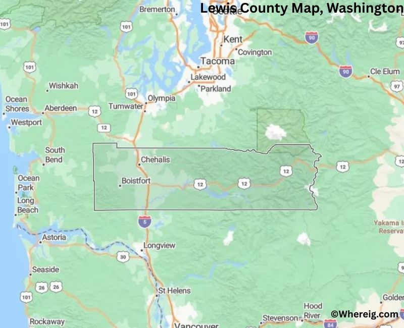
About Lewis County Map, Alabama: The map showing the county boundary, county seat, major cities, highways, water bodies and neighbouring counties.
Most Viewed Links
About Lewis County, Washington
Lewis County is located in the southwestern part of Washington, United States. Established in 1845, it is one of the oldest counties in the state and was named after Meriwether Lewis of the Lewis and Clark Expedition. The county seat and largest city is Chehalis, while Centralia serves as another important commercial center in the county.
Population
According to the United States Census Bureau, the population of Lewis County was 82,149 as recorded in the 2020 Census. The county includes a mix of small cities, rural communities, and forested areas, with residents concentrated in Chehalis and Centralia.
Area and Geography
According to the United States Census Bureau, Lewis County covers a total area of approximately 2,436 square miles, including about 2,403 square miles of land and 33 square miles of water. The county features forested mountains, river valleys, and agricultural land, reflecting its location between the Cascade Range and the Pacific coastal region.
Bordering Counties
Lewis County shares borders with Grays Harbor County to the west, Thurston County to the north, Pierce County to the northeast, Yakima County to the east, Skamania County to the southeast, Cowlitz County to the south, and Pacific County to the southwest.
Major Cities and Communities
The principal cities in Lewis County include Chehalis, Centralia, Morton, and Toledo. Chehalis serves as the county seat, while Centralia is known for its historic downtown and retail centers.
Attractions and Recreation
Lewis County offers access to outdoor recreation including hiking, fishing, and camping in forested areas and river valleys. Mount Rainier National Park lies to the northeast of the county, drawing visitors to the broader region for scenic and recreational activities.
Transportation
Major transportation routes serving Lewis County include Interstate 5 and U.S. Route 12, providing connections to Seattle, Portland, and other parts of the Pacific Northwest.
Explore more counties in Washington Counties or view the complete USA States Map section for additional geographic information.
Sources:
Population and area data sourced from the United States Census Bureau (2020 Census). General county information referenced from the Official Lewis County Government Website.
Facts about Lewis County, Washington
| Country | United States |
| State | Washington |
| Region | Southwestern Washington |
| County Seat | Chehalis |
| Named After | Meriwether Lewis (of the Lewis and Clark Expedition) |
| Established | 1845 |
| Organized | 1845 |
| Coordinates | 46.5770° N, 122.3920° W |
| Total Area | 2,436 sq mi |
| Land Area | 2,403 sq mi |
| Water Area | 33 sq mi |
| Population (2020) | 82,149 |
| Population Rank | Mid-sized county in Washington |
| Largest City | Centralia |
| Main Industries | Forestry, Manufacturing, Agriculture, Healthcare |
| Major Highways | Interstate 5, U.S. Route 12 |
| Time Zone | Pacific Time (UTC−08:00) |
| Known For | Mount St. Helens access, Timber industry, Chehalis River Valley |
| Website | https://lewiscountywa.gov |
Top Attractions in Lewis County, Washington
- Mount St. Helens National Volcanic Monument (nearby) – Volcanic landscapes and views.
- Mount Rainier National Park (nearby) – Alpine scenery and hiking.
- Lewis and Clark State Park – Forest trails and historic site.
- Chehalis-Centralia Railroad & Museum – Scenic train rides.
- Veterans Memorial Museum – Military history exhibits.
- Rainbow Falls State Park – Riverfront camping and trails.
- Millersylvania State Park (nearby) – Lakes and forest recreation.
- Centralia Downtown Historic District – Shops and architecture.
- Chehalis River – Fishing and paddling.
- Fort Borst Park – Historic structures and open space.
- White Pass Scenic Byway (nearby) – Mountain driving route.
- Lewis County Historical Museum – Local history displays.
Cities & Towns in Lewis County, Washington
Centralia, Chehalis, Morton, Napavine, Vader, Toledo, Mossyrock, Pe Ell, Winlock, Onalaska, Randle, Adna, Mineral, Toledo
- Adams County Map, WA
- Asotin County Map, WA
- Benton County Map, WA
- Chelan County Map, WA
- Clallam County Map, WA
- Clark County Map, WA
- Columbia County Map, WA
- Cowlitz County Map, WA
- Douglas County Map, WA
- Ferry County Map, WA
- Franklin County Map, WA
- Garfield County Map, WA
- Grant County Map, WA
- Grays Harbor County Map, WA
- Island County Map, WA
- Jefferson County Map, WA
- King County Map, WA
- Kitsap County Map, WA
- Kittitas County Map, WA
- Klickitat County Map, WA
- Lewis County Map, WA
- Lincoln County Map, WA
- Mason County Map, WA
- Okanogan County Map, WA
- Pacific County Map, WA
- Pend Oreille County Map, WA
- Pierce County Map, WA
- San Juan County Map, WA
- Skagit County Map, WA
- Skamania County Map, WA
- Snohomish County Map, WA
- Spokane County Map, WA
- Stevens County Map, WA
- Thurston County Map, WA
- Wahkiakum County Map, WA
- Walla Walla County Map, WA
- Whatcom County Map, WA
- Whitman County Map, WA
- Yakima County Map, WA
- Alabama Counties
- Alaska boroughs
- Arizona Counties
- Arkansas Counties
- California County Map
- Colorado Counties
- Connecticut Counties
- Delaware Counties
- Florida County Map
- Georgia County Map
- Hawaii Counties
- Idaho Counties
- Illinois Counties
- Indiana Counties
- Iowa Counties
- Kansas Counties
- Kentucky Counties
- Louisiana Counties
- Maine Counties
- Maryland Counties
- Massachusetts Counties
- Michigan County Map
- Minnesota Counties
- Mississippi Counties
- Missouri Counties
- Montana Counties
- Nebraska Counties
- Nevada Counties
- New York Counties
- New Hampshire Counties
- New Jersey Counties
- New Mexico Counties
- North Carolina Counties
- North Dakota Counties
- Ohio County Map
- Oklahoma Counties
- Oregon Counties
- Pennsylvania Counties
- Rhode Island Counties
- South Carolina Counties
- South Dakota Counties
- Map of Tennessee
- Texas County Map
- Utah Counties
- Vermont Counties
- Virginia Counties
- Washington Counties
- West Virginia Counties
- Wisconsin Counties
- Wyoming Counties